Issue Date: Sunday, August 13, 2017
Issue Time: 10:30AM MDT
—LOW flood threat Northeast Plains, Palmer Ridge, Southeast Plains
Less low-level clouds over Colorado again this morning making for a pleasant start to the day. A trough located over the Pacific NW continues to release multiple mid-level waves through Colorado along the 500mb flow. Another wave is expected this afternoon over southern Colorado that will enhance daily thunderstorm activity over the southern Front Range and Southeast Mountains. A weak 500mb ridge will build over Wyoming today and the associated W/NW mid-level flow will continue to steer storm motion to the E/SE as the thunderstorms move into the adjacent plains. At the surface, a lee trough is expected to set up over and with this boundary, low-level moisture is expected to increase to the east, while the west remains drier. The best instability and shear will also be over the Southeast Plains this afternoon and evening, which could help produce gusty winds and hail on top of heavy, local rainfall. Some storms are expected to move into the Northeast Plains that form over the Cheyenne Ridge. Higher moisture with dew points in the mid-50s to 60F, may support 1-hour rain rates up to 1.8 inches and severe storms will also have large hail and gusty winds.
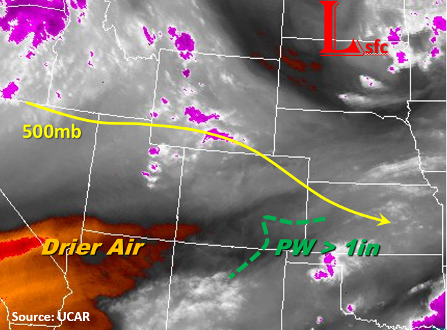
Diurnal heating patterns will allow scattered storms to begin to form over the higher terrain after 1PM. Drier air should limit coverage over the San Juan Mountains and a mid-level wave will enhance storms that form along the Southeast Mountains. Downsloping winds associated with the lee trough will limit thunderstorm formation over the Front Range. Storms that do form over the mountains will have lower atmospheric moisture and will produce gusty winds rather than heavy rainfall. As the storms move off the eastern mountains in the afternoon, they will favor the higher moisture and terrains on the Palmer and Raton Ridge. Severe thunderstorms are possible with winds up to 60mph and 2 inch hail as the storms move east into the plains. A cluster of storms form in the evening and moves SE exiting the state around midnight. With elevated flows along the Arkansas River basin and widespread precipitation, the Low flood threat will include the Arkansas River from La Junta to the Kansas border for minor flooding.
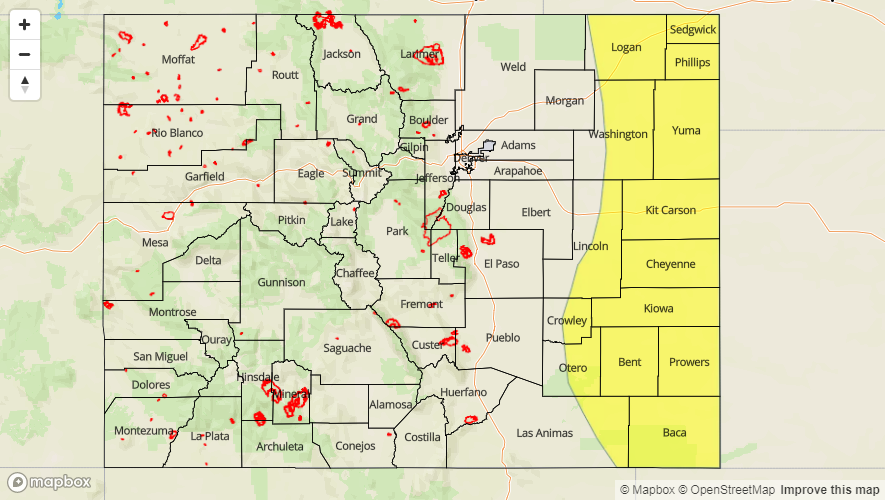
Today’s Flood Threat Map
For more information on today’s flood threat, see the map below (hover over threat areas for more details). For Zone-Specific forecasts, scroll below the map.

Zone-Specific Forecasts:
Front Range, Urban Corridor, Palmer Ridge, Northeast Plains, Southeast Mountains, Raton Ridge, Southeast Plains:
Mostly sunny this morning becoming partly cloudy this afternoon. Some severe storms are possible today over the eastern plains with the main threats being damaging winds and large hail (2 in) as well as arroyo, field, road flooding. Max 1-hour rainfall up to 2.5 inches (east), 0.8 inches (west). Minor riverine flooding along the Arkansas River may be possible from La Junta to the Kansas border along more narrow portions of the river. A Low flood threat has been issued today.
Primetime: 2PM to 12AM
Northwest Slope, Grand Valley, Southwest Slope, Northern Mountains, Central Mountains, San Juan Mountains, San Luis Valley:
Sunny this morning with more showers over the Northern and central Mountains. Max 1-hr rainfall up to 0.7 inches with storm totals up to 1 inch. There is a no flood threat for today.
Primetime: 1PM to 8PM