Issue Date: Thursday, August 10, 2017
Issue Time: 10:40AM MDT
—MODERATE flood threat for Southeast Plains
—LOW flood threat for Urban Corridor, Front Range, Palmer Ridge, Northeast Plains and Raton Ridge
—PM update possible today
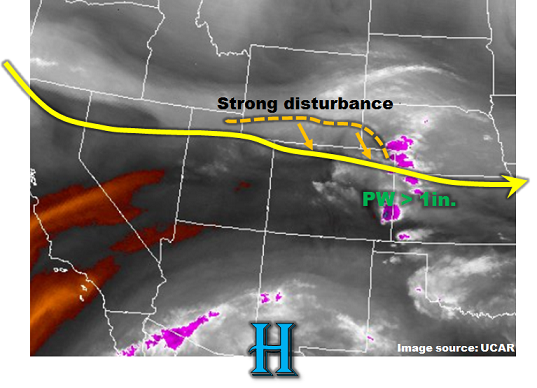
The seemingly unending string of active weather across colorful Colorado will continue once again today. As shown in the water vapor image, below, several important features will combine to produce numerous rounds of shower and storm activity today. First, a strong upper-level disturbance is noted in southern Wyoming. This will slowly move southward throughout the day. To its south, positive vorticity advection will support large-scale upward motion and enhance precipitation. Additionally, a developing jet streak will form over Colorado, further enhancing upward motion as Colorado will lie in the favorable right “exit” region of this jet streak. Second, plenty of moisture remains in eastern Colorado this morning. Surface dew point temperatures are in the 50s and 60s, which is above normal for this time of year. The moisture is not just limited to the surface but extends through a deep layer of the atmosphere, suggesting large warm layer depths and in turn, efficient warm coalescence rainfall generation within thunderstorm clouds. Finally, a surface front has entered northeast Colorado and will continue to push southwest through the day. This will be tempered by the still-strong August sun, but the front will provide a surface convergence boundary for storm formation across the Northeast Plains. The saving grace today that will limit the flood threat will be fast southeasterly steering winds above 25 mph, which will generally limit rainfall in any given location.
Overall, we expect numerous rounds of showers and thunderstorms today across eastern Colorado. Initial coverage will be over the higher terrain, though storms should have little problem surviving on the eastward trek across the Plains today. The fast steering winds suggest a Low flood threat is appropriate for most regions. However, a small region with a Moderate flood threat will exist in far southeast regions where storm complexes are expected to be the largest, and thus multiple hours of heavy rainfall are possible. Activity will continue late into the evening and into the overnight hours especially across far eastern areas. Portions of the Arkansas River, especially towards the Kansas border are included in the Moderate threat and riverine flooding is possible today.
In addition to the flood threat, severe weather will be likely especially during the mid/late afternoon. Very large hail up to 2.75 inches, along with gusty winds up to 75 mph are possible with the strongest cells.
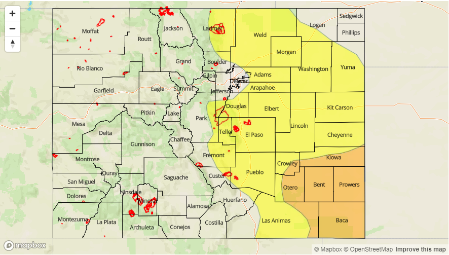
Today’s Flood Threat Map
For more information on today’s flood threat, see the map below (hover over threat areas for more details). For Zone-Specific forecasts, scroll below the map.

Zone-Specific Forecasts:
Front Range, Urban Corridor, Palmer Ridge, Northeast Plains, Southeast Mountains, Raton Ridge, Southeast Plains:
Scattered showers and thunderstorms developing by early afternoon. Highest coverage will be over the higher terrain as well as farther east across the Plains. Max 1-hour rainfall up to 2.4 inches (east) and 1.9 inches (west). Max 3-hour rainfall up to 3.8 inches across eastern areas. A Low flood threat has been posted for isolated flash flooding, small stream flooding, mud flows and debris slides (for higher elevations). A Moderate flood threat is in place for far southeast areas, where impacts will also include potential riverine flooding due to the elevated stream over the Arkansas River and its tributaries. Most activity will subside shortly after sunset, but isolated to scattered storms will continue, especially across eastern areas, well into the overnight hours.
Primetime: 12PM to 4AM
Northwest Slope, Grand Valley, Southwest Slope, Northern Mountains, Central Mountains, San Juan Mountains, San Luis Valley:
Partly cloudy early with isolated to scattered showers and thunderstorms developing by afternoon. Highest coverage will be over northwest areas (especially north of I-70). Max 1-hour rainfall up to 0.7 inches is possible. Gusty winds up to 50 mph and small hail could accompany the strongest cells. Activity will quickly subside after sunset.
Primetime: 12PM to 9PM