Issue Date: Wednesday, August 9, 2017
Issue Time: 10:40AM MDT
— LOW flood threat for the Raton Ridge
Visible satellite shows a bit of fog and low-level clouds again this morning over the northern mountains and Southeast Plains. There are a few light showers over the Northeastern Plains and Southwest Slope, but the majority of this cloud cover will burn off throughout the day with stronger daytime heating. High temperatures today continue to trend upwards, but still will be a bit below climatology. Abundant sunshine will allow some instability this afternoon, but a decrease in moisture will limit severe storm potential and rain totals further north. Shortwaves will continue to be embedded in the west/northwest flow aloft enhancing storms over the northern portion of the state today. Precipitable Water (PW) is lower than the previous few days with 0.85 inches at Denver and 0.8 inches at Grand Junction, which should limit heavy precipitation. Drier mid-levels on top of decreased surface moisture over the western slope should heavy rainfall once again. PW remains over an inch in the far eastern plains and will stay elevated throughout the day with S/SW low-level flow.
Storms will begin to fire off the higher terrain early this afternoon. Greatest instability will be further south and over the SE corner of the state. Some shear will also be present over the Southeast Plains this afternoon, which may help produce some severe thunderstorms. As far as coverage, storms will be more isolated than yesterday and favor the Raton and Palmer Ridge. While the Front Range will also initiate storms this afternoon, lower moisture should keep storm totals under the flood threat criteria. These storms will be the most likely to produce gusty winds. Further south, thunderstorms that form will produce gusty winds, large hail and quick, heavy precipitation. Saturated soils over Las Animas County warrant a Low flood threat for today with storm totals near 1.5 inches. Fast storm motion to the E/SE will also contribute to lower storm precipitation totals. Over the Western Slope, storm coverage will favor the Northern and Central Mountains with 1-hour rain rates up to 0.5 inches. Storms will quickly dissipate this evening over the mountains and by may go a bit into the evening hours over the eastern plains with lingering light showers overnight.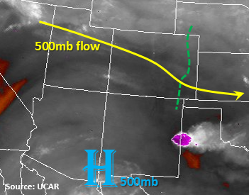
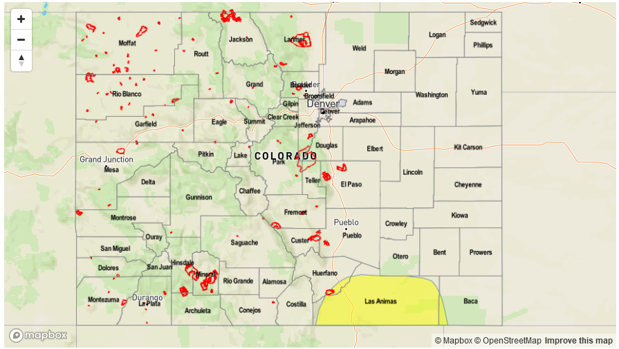
Today’s Flood Threat Map
For more information on today’s flood threat, see the map below (hover over threat areas for more details). For Zone-Specific forecasts, scroll below the map.

Zone-Specific Forecasts:
Front Range, Urban Corridor, Palmer Ridge, Northeast Plains, Southeast Mountains, Raton Ridge, Southeast Plains:
Partly cloudy this morning but daytime heating should burn off most of the cloud cover. Some severe storms are possible today over the SE Plains and will initially favor the Palmer and Raton Ridge. Max 1-hour rainfall up to 1.5 inches (east), 0.9 inches (west). Riverine flooding along Fountain Creek and the Arkansas River will be monitored closely with saturated soils. A Low flood threat has been issued today.
Primetime: 1PM to 12AM
Northwest Slope, Grand Valley, Southwest Slope, Northern Mountains, Central Mountains, San Juan Mountains, San Luis Valley:
Mostly sunny and pleasant day with temperatures still a bit below climatology. Some cloud cover this afternoon with PM storms over the NW corner of the state. A couple embedded shortwaves will help enhance showers over the Northern and Central Mountains. 1-hour rain rates up to 0.5 inches (north) and .3 inches (south). There is a no flood threat for today.
Primetime: 1PM to 9PM