Issue Date: Tuesday, August 8, 2017
Issue Time: 10:50AM MDT
— LOW flood threat Northwest Slope, Northern Mountains, Front Range, Urban Corridor, Northeast Plains, Palmer Ridge, Southeast Mountains, Central Mountains, Southeast Plains, Raton Ridge, Grand Valley
With the broad ridge over the western US, Colorado will continue to be under westerly flow once again. Cloud cover this morning is heaviest in the eastern plains where some showers are still lingering from last night. This disturbance should exit over the Kansas border later this morning. Fog and low-level clouds are present once again with the moist atmosphere. Precipitable Water (PW) at Denver was measured at 1 inch and 1.03 inches over Grand Junction. Temperatures will be up to 10F warmer than yesterday, which should help burn off some of the cloud cover and help create more instability than yesterday. Similar to yesterday, mid-level disturbances will move through the state, which depending on timing, could help enhance the diurnal upslope pattern.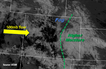
Westerly flow over western Colorado will dry out the mid-levels a bit, but PW values will be high enough for storms to form over the higher terrain favoring the north. The precipitation seems to come in a couple of waves, with the strongest precipitation over the Roan Plateau/Flat Tops and portions of the Central Mountains. A Low flood threat has been issued with storm totals as high as 1.5 inches over this region. Threats include mud flows, debris slides and flash flooding of roads and small streams over saturated soils.
Southeasterly flow over the eastern plains should help keep low-level moisture intact for storms later this afternoon with dew points over Kansas and Oklahoma in the low 60s. Storms will begin to fire over the higher terrain around 1PM and will be more scattered in nature than yesterday. While 1-hour storm totals are below flood thresholds, storm totals of 1.2 inches over saturated soils will increase the chance of mud flows and debris slides. As storms move off the mountains in to the adjacent plains, they will favor the higher terrains of the Palmer Divide and Raton Ridge. Models also have the better instability and a bit of shear over the Southeast Plains, so small hail is possible. It is also possible this afternoon that storms that form over the Cheyenne Ridge will move into the Northeast Plains later this evening. The threat over the mountains and western slope should end this evening, but a few showers may linger overnight with the support of a shortwave and low-level moisture. Over the plains, there is a threat should cease around midnight.
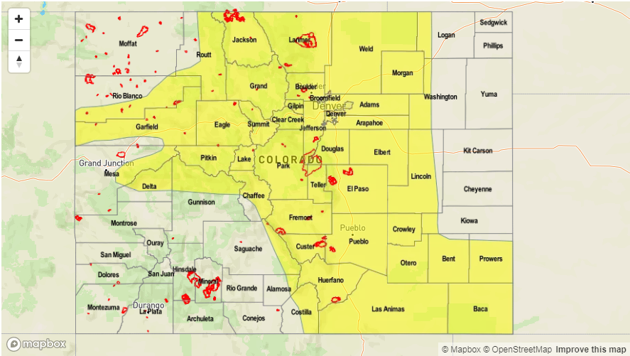
Today’s Flood Threat Map
For more information on today’s flood threat, see the map below (hover over threat areas for more details). For Zone-Specific forecasts, scroll below the map.

Zone-Specific Forecasts:
Front Range, Urban Corridor, Palmer Ridge, Northeast Plains, Southeast Mountains, Raton Ridge, Southeast Plains:
Low-level clouds and rain this morning with a couple rounds of precipitation again. Storms will become more severe where sun is able to break through and create instability and with better shear, which is most likely over the Southeast Plains. Max 3-6 hour rainfall up to 2.8 inches (east), 1.2 inches (west). Riverine flooding along Fountain Creek and the Arkansas River will be monitored closely with saturated soils and widespread rainfall again, though no threat is warranted at this time. A Low flood threat has been issued today.
Primetime: 1PM to 12AM
Northwest Slope, Grand Valley, Southwest Slope, Northern Mountains, Central Mountains, San Juan Mountains, San Luis Valley:
A couple embedded shortwaves will create two rounds of rainfall today. 3-6 hour totals up to 1.5 inches over the Flat Tops/Roan Plateau and portions of the central mountains put it at risk for mud flows, debris slides and road flooding. 3-6 hr rain totals up to 1.2 inches possible (north) and 1 inch (south). There is a Low flood threat for today.
Primetime: 12PM to 10PM