Issue Date: Monday, August 7, 2017
Issue Time: 11:00 AM MDT
Summary:
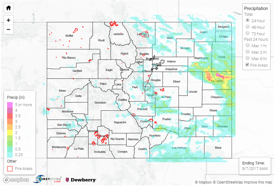
As storms began to build over the mountains in the early afternoon, the first set of storms fired over the western slope. The SW corner of the state was the center of action yesterday, but lower Precipitable Water (PW) favored strong winds more than heavy rainfall. The initial wave of convective storms east of the Continental Divide favored the areas that were able to produce higher instability from less cloud cover. Two of those places were along the higher terrain of the Palmer and Raton Ridge. Towards the evening hours, a second batch of thunderstorms developed further north over the Urban Corridor and Northeast Plains with the help of strong low-level moisture, a mid-level vorticity maximum and upper-level jet support. The thunderstorms on the eastern plains formed two clusters north and south of the Palmer Ridge with the cluster to the north producing the heavier showers. The northern mesoscale convective system (MCS) moved south/southeast throughout the night and eventually exited the state this morning. There were several Areal Flood Advisories throughout the day.
Over the Western Slope, storm totals were less than Saturday. Gusty winds accompanied the thunderstorms with a 55 mph gust recorded at the airport in Rifle. The Lily Pond SNOTEL site recorded the highest observation for the 24-hour period at 0.7 inches. Over the Southeast Mountains, the Apishapa SNOTEL site recorded 1.2 inches yesterday with 1-hour rainfall totals of 0.5 inches. Over Colorado Springs, storm totals were estimated at 2.5 inches with a CoCoRaHS station recording 1.94 inches. The most impressive rainfall was over Kit Carson County where the cluster of storms formed in the evening hours. A CoCoRaHS station recorded 6.2 inches of rain and another station nearby recorded 4.06 inches. Radar estimates of 1-hr rain rates are as high as 3 inches. Road and ditch flooding was reported near Burlington. There were no other flood reports as of this morning, although rain amounts in that range definitely caused flooding over the county.
To see how much precipitation fell in your area, take a peek at the State Precipitation Map below.