Issue Date: Sunday, August 6, 2017
Issue Time: 10:10 AM MDT
Summary:
An active weather pattern remains in place over Colorado, as scattered to numerous thunderstorms formed again yesterday. The trough located across the plains and weak jet streak near Colorado continue to usher in shortwaves that amply the diurnal weather patterns and help continue showers overnight. Precipitable Water (PW) values over 1 inch over the eastern plains and southwest corner of the state helped supply moisture to the thunderstorms yesterday. While atmospheric conditions were again marginal for a flood threat, storms produced high efficient rainfall rates. Storms formed over the high terrain midafternoon yesterday, and by late afternoon made it over the adjacent plains. Outflow boundaries from the initial storms helped create low-level convergence and more low-level moisture for other thunderstorms formation. Moisture advection from Utah with the west/southwest flow helped trigger numerous thunderstorms over the western slope as well.
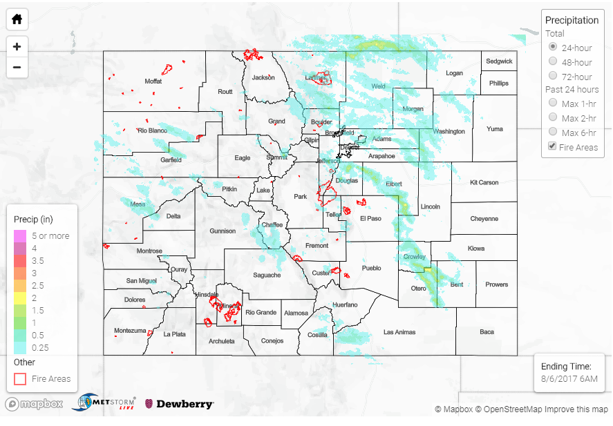
Over the higher terrain in the eastern portion of the state, storms favored the Front Range. Urban Drainage and Flood Control District (UDFCD) mesonet recorded 24-hour rain totals as high as 0.87 inches over the mountains. Over the western slope in the higher terrains, rain rates were just under 1 inch with the highest recorded storm total being 1.15 inches. Radar estimates were as high as 1.8 inches. There was a Flood Advisory and Flash Flood Warning for Garfield County during early in the evening hours. Rainfall totals of 1.8 inches created mud flows and flash flooding along Government Creek near Rifle, Colorado. A mud flow also occurred in Rio Blanco. A heavy rainfall report was recorded in Redlands, Colorado for 0.86 inches of rain. Radar estimates were 1.5 inches over this area.
Over the plains, the highest precipitation producing storms were over Crowley and Otero County. Otero County had a CoCoRaHS gage captured 2.15 inches. Radar estimates were as high as 2.5 inches. In the Denver Metro area, rain gages captured 0.87 inches in 30-minutes, but 1-hour rainfall totals were under 1 inch. Further south over Douglas County, a flood advisory was issued, where 1 inch of rain was recorded at a CoCoRaHS station. There were no storm reports over the eastern portion of the state as of this morning.
To see how much precipitation has fallen in your neighborhood, scroll down and take a look at the State Precipitation Map.