Issue Date: Thursday, August 3, 2017
Issue Time: 10:15AM MDT
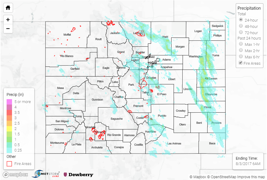
Summary:
Yesterday’s rainfall was associated with a couple different features. Over the mountains, storms were triggered by upslope flow midday. These storms were not accompanied by much moisture, so their rainfall totals were limited and mostly produced gusty winds. Over the eastern plains, thunderstorms began to form along the first boundary around 4PM. With better moisture, instability and shear, these storms quickly became severe and had large hail up to 2 inches in diameter. The fast moving pace of the storms to the SSE limited how much rainfall they were actually able to drop. Lastly, overnight the cold front pushed through the state and produced thunderstorms over the Front Range and Urban Corridor.
While the moisture in the atmosphere was limited yesterday, there were a couple flash flood warnings and areal advisories for the Southeast Mountains over the Haden Pass and Junkins burn scars. Radar total storm estimates are 1.5 inches. Over the San Jan Mountains, the Lily Pond SNOTEL station near Jasper captured 1.1 inches with a 1-hour total of 0.8 inches. Over the Northeast Plains, total rainfall was estimated at 2.2 inches with 1-hour rain rates up to 1.5 inches. Two Flood Warnings were issued, but there were no flooding reports as of this morning. The only storm reports were strong outflow winds breaking off tree limbs in Cheyenne County. Lastly, the cold front that passed though overnight had rainfall amounts over 1 inch an hour with 0.5 inches in 10 minutes over a couple of locations in the UDFCD Alert mesonet. Both Lakewood Gulch and Illif Pond hit their upper limits, but no flooding was reported. Cherry Creek continues to run high this morning, but is expected to recover throughout the morning. Scattered storms continued this morning over the eastern plains along and near the upper-level disturbance.
Flooding was not reported on Wednesday. For rainfall estimates in your neighborhood, take a peek at the State Precipitation Map below.