Issue Date: 5/25/2015
Issue Time: 10:33 AM
LOW FLOOD THREAT IS FORECAST FOR PORTIONS OF THE SOUTH PLATTE AND ARKANSAS RIVERS. A LOW FLOOD THREAT IS ALSO FORECAST FOR POTIONS OF THE FRONT RANGE, URBAN CORRIDOR, PALMER RIDGE, SOUTHEAST PLAINS, RATON RIDGE, AND SOUTHEAST MOUNTAINS.
The mid-/upper-level low that moved across the state yesterday is centered over NE Colorado/W Nebraska this morning. As this continues to push to the east-northeast, Colorado will come under the influence of weak subsidence behind the low. Despite this, there will be enough residual moisture, instability, and orographic influences to produce another afternoon and evening of isolated-to-scattered showers and thunderstorms across Colorado.
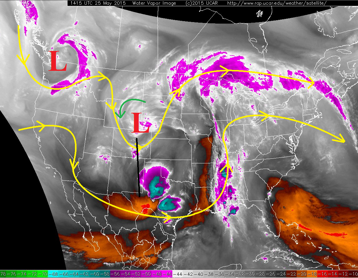
The most numerous storms will occur over and near the higher terrain as orographics play a key role in development. Above 8,000-8,500 feet, snow/graupel will fall, with rain below those elevations. Further east over the Plains, storms will rely on relatively weak instability and residual moisture to develop/maintain isolated showers and thunderstorms. The low flood threat area is as much a result of saturated soils as it is rain rates; overall, rain rates will not be particularly impressive (most between 0.25-0.5 inches/hour), but it will not take much more than that over certain areas to create flash flooding issues. Rain rates, as well as timing, will be broken down in the zone-specific forecast discussions.
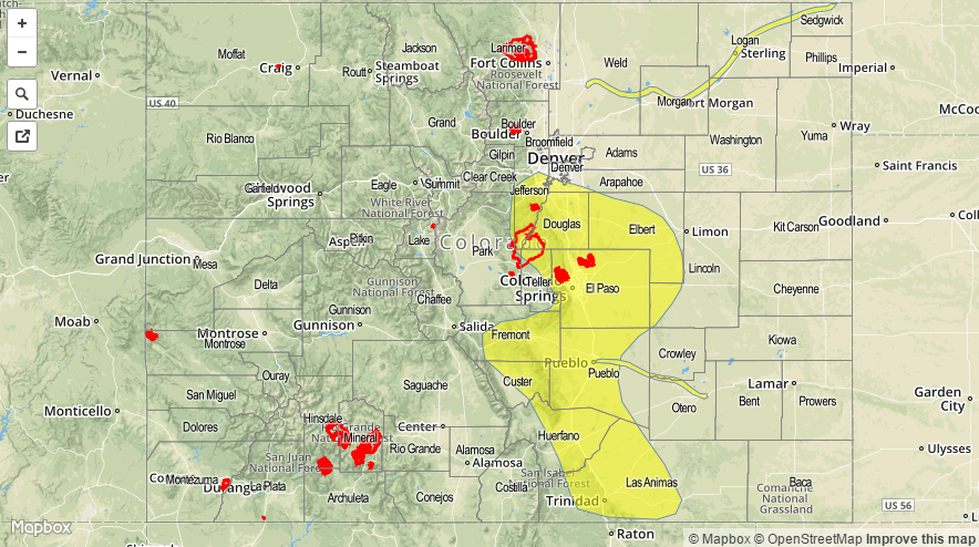
Today’s Flood Threat Map
For more information on today’s flood threat, see the map below (hover over threat areas for more details). For Zone-Specific forecasts, jump below the map.

Zone-Specific Forecasts
Front Range, Urban Corridor, Palmer Ridge:
Isolated-to-scattered showers and thunderstorms will develop once again around noon, continuing through the evening before diminishing after sunset. Southern portions of the regions will have the best chance for a storm or two to become more organized, producing rain rates of 0.7-1.1 inches/hour. A storm with rain rates in this range will be capable of producing flash flooding, especially considering the already saturated soils, thus the low flood threat.
Timing: Noon – 10 PM
Northeast Plains, Southeast Plains, and Raton Ridge:
Isolated showers and thunderstorms are on tap again this afternoon and evening, with the best relative chances near the interface with the higher terrain. Western portions of the Southeast Plains and the Raton Ridge will have the best chance for a strong thunderstorm to develop, producing rain rates in the 0.7-1.2 inches/hour range, which is the reason for the low flood threat in those areas. Otherwise, rain rates will mainly be in the 0.25-0.5 inches/hour range.
Timing: 1 PM – 9 PM
Southeast Mountains, San Luis Valley, Grand Valley, Southwest Slope, Northern Mountains, Central Mountains, San Juan Mountains, and Northwest Slope:
Scattered showers and weak thunderstorms are expected again today and tonight, producing snow/graupel above 8-8,500 feet and rain below those elevations. Rain rates will typically be in the 0.25-0.5 inches/hour range, but a stronger thunderstorm over the Southeast Mountains will hold the potential to produce rain at 0.7-1.1 inches/hour.
Timing: 11 AM – 9 PM, a few showers lingering until 11 PM.