Issue Date: Friday, July 21, 2017
Issue Time: 10:30AM MDT
— MODERATE flood threat for Junkins fire scar
— MODERATE/LOW flood threat for parts of Palmer Ridge, Urban Corridor, Front Range, Northwest Slope, Grand Valley, Northern Mountains, Central Mountains, San Juan Mountains, Southwest Slope, Southeast Mountains, Northeast Plains
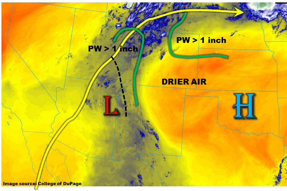
A persistent weather pattern continues over Colorado this morning. As shown in the water vapor image, below, the main features are a weak upper-level ridge to our southeast, along with a plume a monsoon moisture being transported northward along the NM/AZ border. A sizeable area of drier air is once again found in southeast Colorado, which will continue to limit heavy rainfall chances there. Expanding now to include more detail, there is a remnant mesoscale low pressure clearly seen on the visible satellite image in northeast AZ. At the mid-levels this feature is being supported (or is supporting!) a vorticity maximum located over the four corners. This is not expected to move much, but will likely provide enhanced moisture advection into southwest Colorado, which will in turn continue to favor heavy rainfall. Additionally, mid-level temperatures have dropped 2-4C over the past 24 hours as the upper-level high is slowly weakened by a large scale trough coming ashore in the Pacific Northwest. The sensible impact will be higher overall precipitation chances for western and central Colorado. A Low flood threat has been posted for a similar domain as yesterday. High resolution guidance is more bullish on max 1-3 hour rain rates, which looks reasonable given the mid-level cooling. Thus, a broad Moderate flood threat has been issued for the foothills of the western slope as well as the Palmer Ridge and neighboring regions. Antecedent rainfall up to 2 inches is also becoming of increasing concern (especially for debris slides) that warrants the Moderate threat.
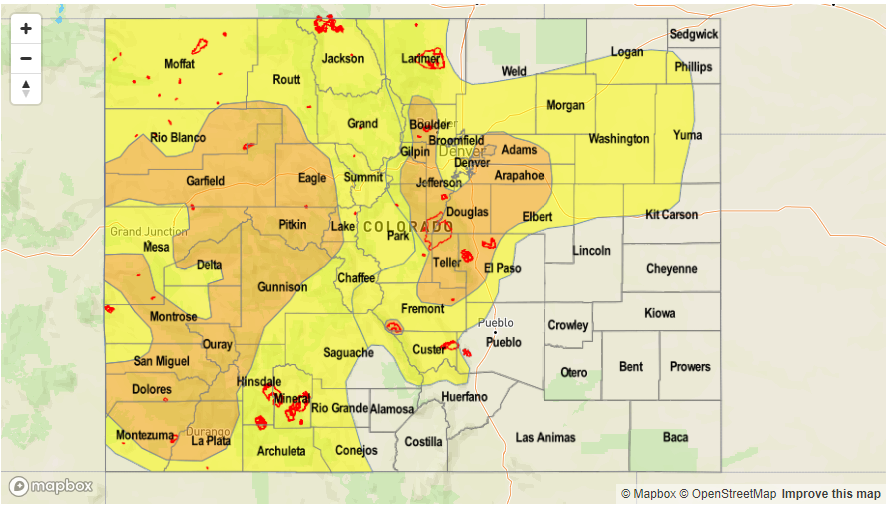
Today’s Flood Threat Map
For more information on today’s flood threat, see the map below (hover over threat areas for more details). For Zone-Specific forecasts, scroll below the map.

Zone-Specific Forecasts:
Northwest Slope, Grand Valley, Southwest Slope, Northern Mountains, Central Mountains, San Juan Mountains:
Partly cloudy early then scattered to numerous showers and thunderstorms developing by noon. Max 1-hour rain rates up to 1.4 inches, with max 3-hour rates up to 2.2 inches. Isolated flash flooding will be possible under the strongest cells. Mud flows and debris slides will be possible not only in areas with new heavy rainfall, but also in areas seeing multiple days of rainfall. A broad Moderate flood threat has been issued with a Low threat surrounding this region. Storms will quickly subside shortly after sunset, with some light to moderate showers possible for a few hours thereafter.
Primetime: 11:30AM to 10PM
Front Range, Urban Corridor, Palmer Ridge, Northeast Plains, Southeast Mountains:
Sunny early then becoming mostly cloudy with scattered to numerous showers and thunderstorms developing shortly after noon. Max 1-hour rainfall up to 2.3 inches below 6,000 feet and up to 1.8 inches above 6,000 feet. Isolated flash flooding, debris slides and mud flows will be possible. Nuisance urban flooding will be likely in the Denver metro and small stream flooding is a possibility in municipal areas with high impervious area. A Moderate flood threat has been issued south and west of Denver metro, with a Low flood threat extending north and east. There is a slight chance of severe weather with the main hazards being hail up to 1.25 inches and gusty winds.
Primetime: 12PM to 10PM
Raton Ridge, San Luis Valley, Southeast Plains:
Sunny and very warm today with isolated showers and thunderstorms possible towards the mountains. Max 1-hour rainfall up to 0.9 inches. Flooding is not expected today.
Primetime: 1PM to 9PM