Issue Date: Monday, July 17, 2017
Issue Time: 10:25AM MDT
—MODERATE flood threat for Hayden Pass burn scar
—LOW flood threat for portions of Northern Mountains, Central Mountains, Front Range, Southeast Mountains, San Juan Mountains and Southeast Slope
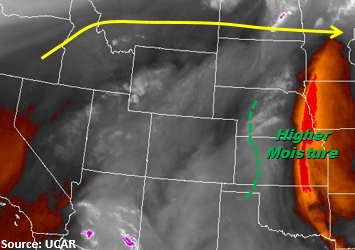
A high pressure ridge continues to hold over Colorado, Nebraska and Wyoming today. With the ridge north of Colorado, limited SE and SW flow at the surface will cap the amount of moisture pulled into the state. There is strong drying over northeastern CO today and the circulation over the SE portion of the state will move into KS limiting storm potential on the Southeast Plains. Precipitable Water (PW) at Denver this morning was 0.84 inches and 0.79 inches in Grand Junction. These are not forecasted to rise much throughout the day. Enough moisture remains in the mountains for thunderstorms to fire again with upslope flow this afternoon. Storms will form more numerously in the northern portion of the mountains compared to yesterday.
As storms begin to move SE off the higher terrain this afternoon, they are expected to weaken. The better moisture remains off to the east over KS and NE. Due to saturated soils in the mountains, expect some extra runoff with storms that form. Moisture will favor the southern mountains and be more widespread in coverage. Recent burn scars in the Southeast Mountains need to be monitored closely as there is sufficient confidence storms that form will have rain rates greater than 0.5 inches. Heavy rainfall could cause local flooding, debris slides and mud flows over the already saturated soils. Storms over the high terrain will begin to dissipate around 10PM.
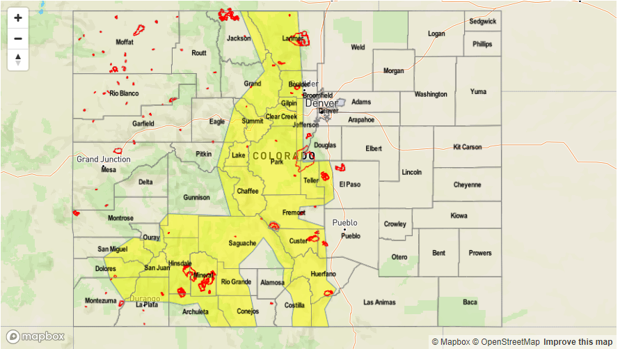
Today’s Flood Threat Map
For more information on today’s flood threat, see the map below (hover over threat areas for more details). For Zone-Specific forecasts, scroll below the map.

Zone-Specific Forecasts:
Northwest Slope, Grand Valley, Northeast Plains, Palmer Ridge, San Luis Valley, Southeast Plains
Mostly sunny today. Isolated showers will form over the higher terrain this afternoon. When they move off the higher terrain, they are expected to weaken quickly. Max 1-hr rain rates of 0.7 inches and storms will begin to dissipate around 10PM. There is no flood threat for today.
Primetime: 12AM to 11PM
Northern Mountains, Central Mountains, Front Range, Urban Corridor, San Juan Mountains, Southeast Mountains, Raton Ridge, Southwest Slope:
Sunny this morning becoming partly cloudy this afternoon as storms begin to form over the higher terrain. Max 1-hr rain rates are expected to be as high as 1.2 inches. Storms will quickly weaken as they move off the higher terrain. Due to saturated soils, flash flooding, small stream flooding, mudslides and debris flows are possible today. A Low threat has been issued. Burn scars need to be monitored closely again today as there is sufficient confidence storms will produce rain rates greater than 0.5 inches per hour. A Moderate flood threat has been posted for the Hayden burn scar due to moist soils from antecedent rainfall the last three days.
Primetime: 12PM to 12AM