Issue Date: 7/15/2017
Issue Time: 8:00 AM
A MODERATE FLOOD THREAT IS FORECAST TODAY FOR PORTIONS OF THE URBAN CORRIDOR, FRONT RANGE, SOUTHEAST MOUNTAINS, PALMER RIDGE, SOUTHEAST PLAINS, AND NORTHEAST PLAINS. A LOW FLOOD THREAT ENCOMPASSES THOSE AREAS, AND INCLUDES PORTIONS OF THE RATON RIDGE, CENTRAL MOUNTAINS, AND SAN JUAN MOUNTAINS.
Underneath the upper-level ridge sits a mid-level disturbance and ample moisture, which will be the main culprits behind another active forecast for today’s period. Comparable to yesterday, storm motions will be fairly slow as steering winds are weak, so expect another day where the main threat from thunderstorms is heavy rainfall. These slow storm motions are evidenced by the ongoing convection over eastern Colorado.
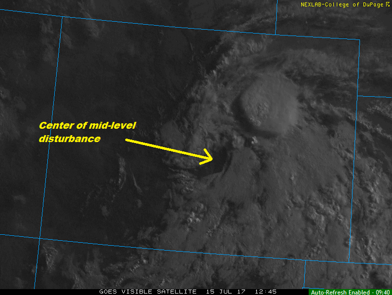
Every region across the state should see at least one shower/storm, with the most activity occurring along and south of I-70. A few showers/storms will persist overnight, mainly across the eastern plains/Palmer Ridge as the disturbance continues to slowly drift towards the CO/KS border. For more information on timing and rain/rates, please see the zone-specific forecast discussions below.
Today’s Flood Threat Map
For more information on today’s flood threat, see the map below (hover over threat areas for more details). For Zone-Specific forecasts, jump below the map.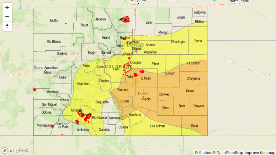

Zone-Specific Forecasts
Urban Corridor, Palmer Ridge, Raton Ridge, Northeast Plains, and Southeast Plains:
Scattered showers/thunderstorms are expected today/tonight, with slow-storm motions keeping heavy rainfall the main threat. Localized ponding issues will occur in poorly drained areas (urban and rural) under most thunderstorms, with a moderate flash flood threat due to stronger thunderstorms. Maximum rain rates are as follows:
Urban Corridor, Raton Ridge, and Palmer Ridge: 1.5-2.0 inches/hour
Northeast Plains and Southeast Plains: 1.5-2.5 inches/hour
Timing: Ongoing – Midnight, with scattered showers/thunderstorms persisting mainly over the Northeast Plains and Southeast Plains into the morning hours tomorrow.
Northern Mountains, Northwest Slope, Front Range, Southeast Mountains, Central Mountains, Grand Valley, Southwest Slope, San Juan Mountains, and San Luis Valley:
Scattered showers/thunderstorms are expected, with the bulk of activity occurring along and south of I-70. Burn scars are the primary concern for the flash flood threat today, as well as areas that have received recent heavy rainfall. Activity will ramp up around 11 AM this morning, increasing in coverage through the afternoon/early evening hours, and then diminishing through the later evening/nighttime hours. Most (if not all) activity should come to an end by midnight. Maximum rain rates are as follows:
Northern Mountains, Northwest Slope, Southwest Slope, and Grand Valley: 0.4-0.8 inches/hour
Front Range, Southeast Mountains, and Central Mountains: 0.9-1.4 inches/hour
San Juan Mountains and San Luis Valley: 0.7-1.1 inches/hour