Issue Date: Thursday, July 13, 2017
Issue Time: 11:00AM MDT
—HIGH flood threat for burn scars over the Southeast Mountains
—MODERATE flood threat for Front Range, Palmer Ridge, Southeast Mountains, Southeast Plains and Raton Ridge
—LOW flood threat for Northwest Slope, Northern Mountains, Front Range, Central Mountains, Grand Valley, Southwest Slope, San Juan Mountains, Southeast Mountains, Southeast Plains, Urban Corridor, Palmer Ridge and Raton Ridge
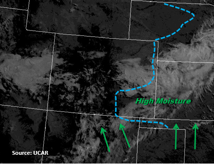
The upper level ridge off to the north and west of Colorado will begin to build and move east today, but will stay far enough north for moisture to return to the state with southerly and southeasterly surface winds. Precipitable Water values currently are 0.91 inches this morning for Denver and 0.97 inches for Grand Junction. PW values over the Southeast Plains are 1.4 inches now and are expected to increase to 1.5 inches again today. Lamar’s current dew point is 66F, which is very high. As the upslope flow sets up, easterly surface winds will help pull even more moisture in from southern KS. There is a lot of mixing out of the moisture in the mid-levels over the Northeast Plains, so storm formation should be confined to the southern high country and Palmer Divide.
Another focal point of heavy rains is over the Southeast Plains where the moisture gradient is marked below. A fair amount of energy is expected to build up over the Southeast Plains during the afternoon, so storms that form off the higher terrain should be able to sustain themselves. Steering winds remain weak, so storms will once again will have access to high PW and be moving slow (to the S/SW) making them heavy rainfall producers. Wet soils will increase runoff as well as field ponding. The main threats today are heavy rain, flash flooding, gusty winds, urban and small stream flooding, mud flows and debris slides. A High threat has again been placed of the recent burn scars in the Southeast Mountains as there is sufficient confidence storms that form will have rain rates greater than 0.5 inches. Heavy rainfall could cause local flooding and debris flows over the already saturated soils. Storms over the high terrain will begin to dissipate around 10PM while thunderstorms in the eastern plains will continue through 2AM.
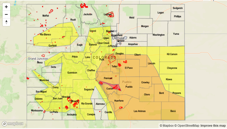
Today’s Flood Threat Map
For more information on today’s flood threat, see the map below (hover over threat areas for more details). For Zone-Specific forecasts, scroll below the map.

Zone-Specific Forecasts:
Northwest Slope, Northern Mountains, Grand Valley, Central Mountains, San Luis Valley, Northeast Plains:
Partly cloudy this morning becoming sunny. Higher precipitation amounts will be over higher terrain in central and southern CO with max 1-hr rain rates of 1 inch. Storms over the higher terrain will end around 10PM. There is a Low flood threat for the Flat Top Mountains, which experienced over an inch of measureable precipitation yesterday. With 1-hour max rain rates of 1.1 inches forecasted here, this could easily trigger mudslides, debris flows and local flash flooding.
Primetime: 11AM to 10PM
Front Range, Southeast Mountains, Urban Corridor, Raton Ridge, Palmer Ridge, Southeast Plains, San Juan Mountains, Southwest Slope:
Partly cloudy this morning becoming sunny. Temperatures should be near normal or a few degrees below. Over the mountains, 1-hr rain rates are expected to be as high as 1.2 inches with 1-hr rain rates as high as 2.5 inches over the eastern plains. Over the eastern plains, 3 hour rainfall totals of 3.25 inches are possible, which is why a Moderate threat has been issued. Flash flooding, urban and small stream flooding, field ponding, mudslides and debris flows are possible today. Some storms over the plains may become severe with winds up to 60 mph and small hail. Burn scars need to be monitored closely again today as there is sufficient confidence storms will produce rain rates greater than 0.5 inches per hour. This paired with moist soil from measurable rainfall the last three days warrants a High threat.
Primetime: 11AM to 2AM