Issue Date: Wednesday, July 12, 2017
Issue Time: 11:00AM MDT
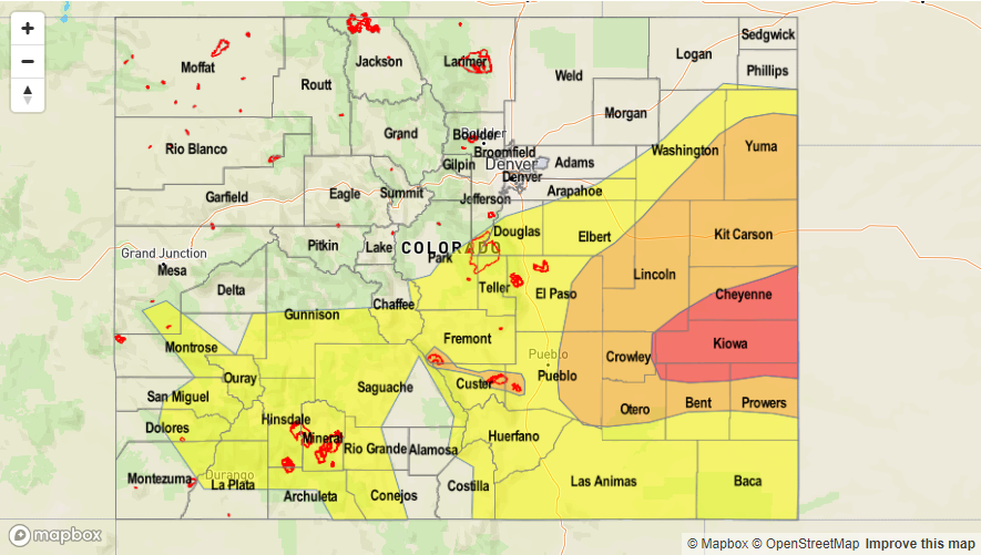
—HIGH flood threat for parts of Southeast Plains
—MODERATE flood threat for Front Range, Urban Corridor, Palmer Ridge, Northeast Plains, Southeast Plains, and burn scars over the Southeast Mountains
—LOW flood threat for Southwest Slope, San Juan Mountains, Southeast Mountains, Raton Ridge, Front Range, Urban Corridor, Southeast Plains, Northeast Plains, Palmer Ridge
PM Update: Near record Precipitable Water exceeding 1.5 inches is noted in eastern Colorado, along with a mesoscale surface low pressure circulation over the southeast part of the state. Numerous rounds of showers and storms are expected, capable of producing very heavy rainfall. Isolated flash flooding is likely over the higher threat area. Farther north, a lack of instability has reduced heavy rainfall chances though showers are still expected well into the evening.
There still seems to be a disturbance over the central and southern portions of Colorado this morning as seen in the visible satellite below. This should move through the state this morning and clouds will begin to burn off early afternoon with daytime heating. The cloud deck will help keep temperatures closer to normal today. Over the plains, a cold front is currently positioned along the WY/NE border and will push southward into the eastern plains early this afternoon. This could help organize a few isolated thunderstorms that form along the high terrain and Palmer Divide. The main threats include heavy rain, flooding, hail and gusty winds. Storms will become widespread on the eastern plains in the early evening hours to midnight.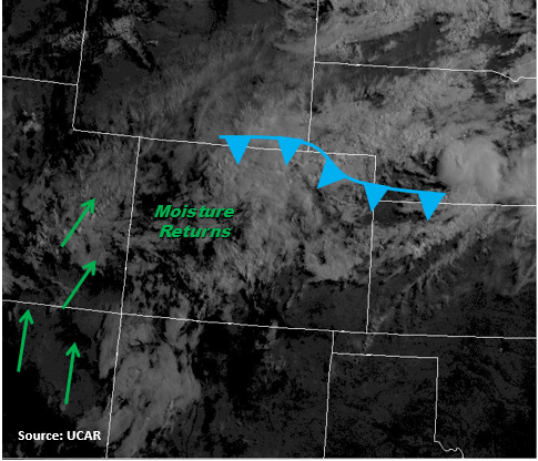
The upper level ridge will begin to rebuild itself this afternoon over Idaho and Montana. Although this will mix out some of the moisture west of the Continental Divide, residual moisture from yesterday will be enough to fire storms off the higher terrain again early this afternoon. Expect rainfall totals to be a bit lower than yesterday as you move north. Current Precipitable Water (PW) readings are 1.2 inches for Grand Junction and 1 inch for Denver. Moisture over Denver is expected to increase to 1.2 inches today with the portions of the eastern plains reaching 1.5 inches. Once the storms begin to move off the higher terrain in the afternoon, expect slow moving storms again today. Threats include heavy local rainfall, urban and small stream flash flooding, debris slides, mud flows and field ponding. Fresh fire scars will need to be monitored throughout the afternoon. The burn scars in the Southeast Mountains have had rain the last couple of days, so another day of rain rates greater than 0.5 inches warrant a High threat. Storms over the high terrain will begin to dissipate around 10PM while thunderstorms in the eastern plains will continue through 1AM.
Today’s Flood Threat Map
For more information on today’s flood threat, see the map below (hover over threat areas for more details). For Zone-Specific forecasts, scroll below the map.

Zone-Specific Forecasts:
Northwest Slope, Northern Mountains, Grand Valley, Central Mountains, San Juan Mountains, Southwest Slope, San Luis Valley:
Partly cloudy this morning with storms beginning to end late morning. Cloud cover will begin to burn off just before storms begin to fire off the high terrain again. Higher precipitation amounts will be in central and southern CO with max 1-hr rain rates of 1.2 inches. Local flash flooding, mudslides and debris flows are possible today which is why a Low Threat is warranted.
Primetime: 11AM to 10PM
Front Range, Southeast Mountains, Urban Corridor, Raton Ridge, Northeast Plains, Palmer Ridge, Southeast Plains:
Partly cloudy this morning in the mountains and Northeast Plains. Expect clouds to burn off midday, but they will help keep temperatures near normal. 1-hr rain rates are expect to be as high as 2.5 inches, which is why a Moderate threat has been issued. Flash flooding, urban and small stream flooding, field ponding, mudslides and debris flows are possible today. Some storms over the plains may become severe with winds up to 60 mph and small hail. Burn scars need to be monitored closely again today as there is sufficient confidence storms will produce rain rates greater than 0.5 inches per hour. This paired with moist soil from measurable rainfall the last two days warrants a High threat.
Primetime: 12AM to 1AM