Issue Date: Tuesday, July 11, 2017
Issue Time: 10:45AM MDT
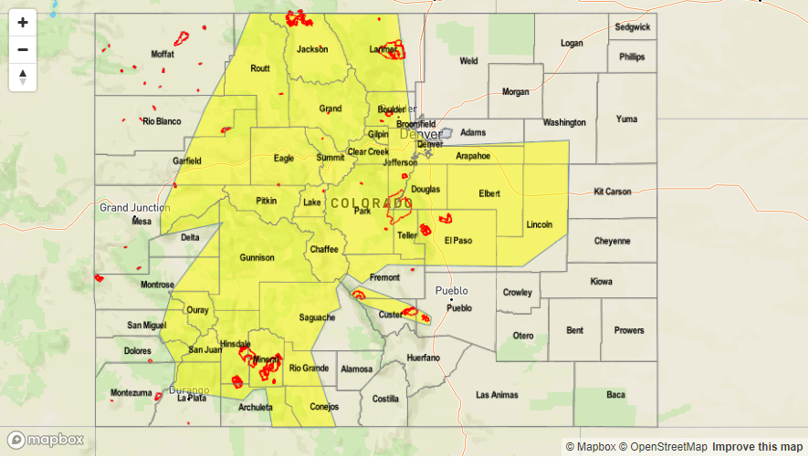
—LOW flood threat for Northwest Slope, Northern Mountains, Front Range, Urban Corridor, Grand Valley, Central Mountains, Palmer Ridge, Southwest Slope, San Juan Mountains, Southeast Mountains
More zonal flow aloft over Colorado will help moisture return to the state today. At the surface, the breakdown of the persistent ridge pattern will allow southwesterly and westerly flow at the surface. This will provide the influx of moisture, especially to the western portion of the Continental Divide. Morning soundings have precipitable water at Denver and Grand Junction higher than this time yesterday, and they are both expected to rise over an inch throughout the day. Strong daytime heating will once again create upslope flow and storms will begin to form over the higher terrain midday. Storm coverage will be more widespread than yesterday.
The storms will move off the mountains mid-afternoon into the southern Urban Corridor, Palmer Ridge and Southeast Mountains, but will not dissipate like yesterday. Weaker winds aloft will limit steering and speed of storms. This combination of slow storms with high moisture will warrant a low threat today. Any storms that form near burn scars need to be closely monitored as they could trigger flash flooding, mudslides or debris flows. Another Low threat was placed over the Junkins and Hayden Pass burn scar due to sufficient confidence any storms that form will produce over 0.5 inches per hour. Additionally, many outflow boundaries from yesterday, and new outflow boundaries that form from storms today, will aid in surface convergence for supplementary storm formation this afternoon and evening. A portion of the jet will dip into northern CO this evening, which will provide extra lift for storms in this area and help trigger a second round of showers into the night. Storms are expected to dissipate over the mountains around midnight and linger into the early morning over the eastern plains.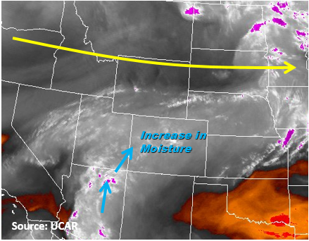
Today’s Flood Threat Map
For more information on today’s flood threat, see the map below (hover over threat areas for more details). For Zone-Specific forecasts, scroll below the map.

Zone-Specific Forecasts:
Northwest Slope, Northern Mountains, Front Range, Central Mountains, Grand Valley, San Juan Mountains, Southwest Slope, San Luis Valley:
Partly cloudy for the western slope and portions of the mountains. It will become sunny today just before storms begin to form over the high country midday. Storms will be more widespread than yesterday with more moisture, so the main threats are heavy local rains, gusty winds and small hail. An upper level jet will drop close to northern CO this evening helping provide additional lift in this area for a second round of storms this evening. Max 1-hour rainfall rates of 1.5 inches are expected over the mountains. 30-min rain rates could be as 0.8 inches. Local flash flooding, mudslides and debris flows are possible today.
Primetime: 11AM to 1AM
Palmer Ridge, Southeast Plains, Raton Ridge, Southeast Mountains, Urban Corridor, Northeast Plains:
Clouds will burn off this morning allowing the sun to shine through. Storms will begin to form over the high country midday. They will move off the mountains mid-afternoon and have max 1-hour rainfall rates of 1.5 inches. 30-min rain rates could be as high as 0.9 inches. The low threat is limited to the southern Urban Corridor over the higher terrain. There was an additional Low threat placed over the Hayden Pass and Junkins burn scar due to sufficient confidence rainfall rates of 0.5 inches per hour are likely. Local flash flooding, mudslides and debris flows are possible today, especially over burn scars.
Primetime: 1PM to 4AM