Issue Date: Sunday, July 9, 2017
Issue Time: 10AM MDT
— Flooding is NOT expected today
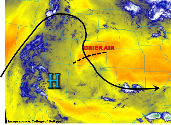
In the wake of yesterday’s weak disturbance, a significantly drier atmosphere is seen across most of Colorado this morning as seen in the low-level water vapor image below. Precipitable water (PW) values have dropped from 0.8 – 1 inch yesterday into the 0.4 – 0.7 inch range today. As the weak disturbance continues to move southward within the clockwise flow around the Great Basin ridge, weak subsidence will follow in its wake. Expect a significant reduction in storm coverage today, with most activity limited to the CO/NM border. Brief heavy rainfall will once again be likely today, but the intensity will not be enough to warrant a flood threat. With increased sunshine expected, very hot temperatures will be back in the forecast unless you are lucky enough to get a rain-cooled outflow boundary later this afternoon.
Today’s Flood Threat Map
For more information on today’s flood threat, see the map below (hover over threat areas for more details). For Zone-Specific forecasts, scroll below the map.

Zone-Specific Forecasts:
San Luis Valley, San Juan Mountains, Southeast Mountains:
Sunny early then partly cloudy with scattered showers and storms developing by early afternoon. Max 30-minute rainfall up to 0.5 inches, with max 1-hour rainfall up to 0.75 inches. Flooding is NOT expected today.
Primetime: 12PM to 8PM
Palmer Ridge, Raton Ridge, Urban Corridor, Northeast Plains, Southeast Plains, Front Range:
Mostly sunny early then partly cloudy with isolated showers and a weak thunderstorm possible over the higher terrain this afternoon. Max 30-minute rainfall up to 0.4 inches, Flooding is NOT expected today.
Primetime: 12PM to 8PM
Grand Valley, Northwest Slope, Northern Mountains, Central Mountains, Southwest Slope:
Sunny early, then partly cloudy and continued warm today with high temperatures 5 – 15F above normal. Isolated to widely scattered thunderstorms and showers are possible this afternoon, with highest coverage across southern areas. Max 30-minute rainfall up to 0.2 inches. Gusty winds and dry lightning with the strongest storms will continue to pose a wildfire threat. Flooding is not expected today.
Primetime: 12PM to 7PM