Issue Date: Saturday, July 8, 2017
Issue Time: 9:35AM MDT
— MODERATE flood threat for Junkins, Beulah Hill and Hayden Pass fire burns
— LOW flood threat for Front Range, Urban Corridor, Palmer Ridge, Southeast Plains, Raton Ridge and Southeast Mountains
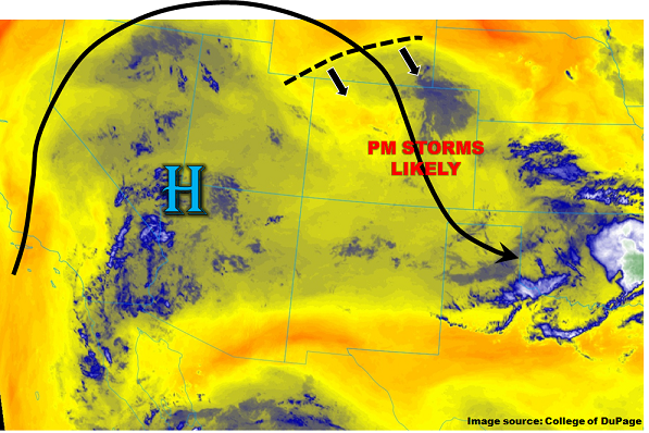
As the water vapor image shows, below, the main player in driving today’s weather across Colorado will continue to be the upper-level ridge located over the southwest US. Although this ridge will promote weak subsidence and above normal temperatures statewide, it is not the full story. Low-level moisture has continued to steadily increase, with Precipitable Water (PW) values exceeding 0.5 inches statewide as of this morning. West of the Continental Divide, this moisture is mainly at mid-levels, thus, though storms will again be seen, heavy rainfall will be lacking. In areas to the east, with PW values exceeding 0.75 inches even for locations above 6,000 feet, isolated heavy rainfall will once again be a good bet today. Compared to yesterday, two other notable features are seen this morning. First, a weak vorticity maximum identified over southern Wyoming will help create lift as it moves southeast across the Colorado. Second, storm steering winds will have a weak easterly component today, implying the potential for training storms near the foothills. A Low flood threat has been issued for parts of east/southeast Colorado today. However, a Moderate flood threat has been posted for the fresh 2016 fire burn areas in the Sangre de Cristo and Wet Mountains.
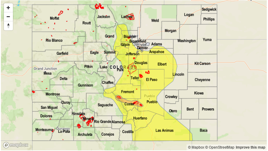
Today’s Flood Threat Map
For more information on today’s flood threat, see the map below (hover over threat areas for more details). For Zone-Specific forecasts, scroll below the map.

Zone-Specific Forecasts:
Palmer Ridge, Southeast Mountains, Raton Ridge, Urban Corridor, Northeast Plains, Southeast Plains:
Mostly sunny early then partly cloudy with scattered to widespread showers and thunderstorms developing by early afternoon. Highest coverage will be closer to the mountains and southern areas. The initial storms will likely produce outflow boundaries for additional activity into the late afternoon and early evening. Max 30-minute rainfall up to 1.5 inches, with max 1 hour rainfall up to 2.2 inches. A Low flood threat has been posted for parts of the region. A Moderate flood threat has been posted for the Hayden Pass, Junkins and Beulah Hill fire scars due to greater than 50% chance of seeing 0.5 inch per hour rainfall intensity.
Primetime: 12PM to 10PM
Grand Valley, Northwest Slope, Northern Mountains, Central Mountains, Southwest Slope, San Luis Valley, San Juan Mountains, Front Range:
Sunny early, then partly cloudy and continued warm today with high temperatures 5 – 10F above normal. Isolated to widely scattered thunderstorms and showers are expected this afternoon, with highest coverage across southern areas. Max 30-minute rainfall up to 0.3 inches, except up to 0.6 inches in the San Juans near the NM border. Gusty winds and dry lightning with the strongest storms will continue to pose a wildfire threat. Flooding is not expected today.
Primetime: 1PM to 8PM