Issue Date: Friday, July 7, 2017
Issue Time: 11:00AM MDT
—Low Threat for Northern Mountains, Urban Corridor, Front Range, Northeast Plains, Palmer Ridge, Southeast Plains and Southeast Mountains
Update:
The Low Threat has been extended south to include all of the Southeast Plains and Raton Ridge. An outflow boundary is moving southeast from Pueblo and El Paso County. With high temperatures, dew points near 50F and the slow moving nature of the storms, local flooding can be expected. Rain rates up to 2.3 inches per hour are expected with 3-hour totals up to 3.6 inches. NWS issued a flood advisory over the Junkins burn scar.
—————————- Previous Discussion —————————-
The high pressure continues to be parked over the four corners region once again today. There is a noticeable uptick in Precipitable Water (PW) this morning across the state, but especially over the eastern plains. Denver’s sounding this morning showed the PW at 0.76 inches and is expected to approach or exceed 1 inch this afternoon. This indicates the potential of thunderstorms capable of heavy rainfall this afternoon. Expect upslope flow again with storms forming over the higher terrain and Palmer Divide. The increase in moisture, will cause thunderstorm formation to be more plentiful across the higher terrain. Dew points are expected to reach 55F-60F on the eastern plains.
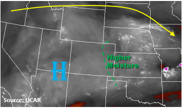
A cold front will drop into the Northeast Plains and stall out over the Palmer Divide this afternoon. This forcing will provide low-level convergence that will generate scattered to numerous thunderstorm development. Severe weather (large hail, strong wind) is possible if it moves through when peak heating and instability are occurring. Outflow boundaries from all storms are likely to provide an additional lifting mechanism for storm formation as they have during the last couple of days. The main threats will be small hail, gusty winds and heavy rain. The main threats will be small hail, gusty winds and heavy rain. Rain rates up to 2.3 inches per hour are forecasted with the increased moisture and slow storm motion. Three hour rain totals could be up to 3.6 inches. A Low Threat has been issued.
Over the Wet Mountains, a separate Low Threat has been issued. There is sufficient confidence that storms that form will have rain rates greater than 0.5 inches per hour. Over the fresh burn scars from last year, these rain rates could trigger flash flooding, mud slides and debris flows.
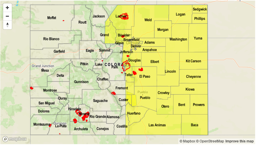
Today’s Flood Threat Map
For more information on today’s flood threat, see the map below (hover over threat areas for more details). For Zone-Specific forecasts, scroll below the map.

Zone-Specific Forecasts:
Northern Mountains, Urban Corridor, Front Range, Northeast Plains, Palmer Ridge, Southeast Plains, Southeast Mountains:
Sunny early with thunderstorms forming over the higher terrain this afternoon. Storms over the eastern plains could become severe with the main threats being small hail and gusty winds. Max 1-hour rainfall for 2.3 inches is possible with the slow moving storms. A Low flood threat has been posted for isolated flash flooding, debris slides and mud flows. A separate Low flood threat has been issued for the Wet Mountains due to sufficient confidence in rainfall rates greater than 0.5 inches occurring over 2016’s burn scars.
Primetime: 1PM to 12AM
Northwest Slope, Grand Valley, Central Mountains, Southwest Slope, San Juan Mountains, San Luis Valley, Raton Ridge:
Sunny early becoming partly cloudy in the afternoon. An isolated shower or weak storm will be possible over higher terrain and close to the mountains. Max 1-hour rainfall up to 0.4 inches under storm cores. Flooding is not expected today.
Primetime: 12AM to 11PM