Issue Date: 7/1/2017
Issue Time: 9:00 AM
NO FLOOD THREAT IS FORECAST.
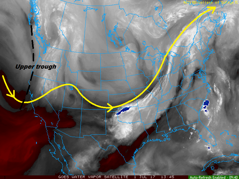
The general forecast for this period across Colorado can be summed up like this: warm and dry, with plenty of sunshine. We can thank a warm, subsident airmass that is building overhead in advance of an upper-level trough along the West Coast for this pleasant outlook. However, as is the case much of the time for Colorado, there is an exception to the rule.
For southern Colorado, mainly for the San Juan Mountains, San Luis Valley, Southeast Mountains, Raton Ridge, and Southeast Plains regions, a few isolated thunderstorms will rumble during the afternoon and evening hours as daytime heating and orographic effects overcome the cap. This activity may occur as far north as the southern reaches of the Front Range/Urban Corridor/Palmer Ridge/Northeast Plains. Flooding is not expected, as moisture is fairly shallow and the environmental support is marginal for any organized, strong activity. The strongest thunderstorms will occur across the Southeast Mountains, Raton Ridge, and Southeast Plains, with the main threat being severe winds and hail.
Today’s Flood Threat Map
For more information on today’s flood threat, see the map below (hover over threat areas for more details). For Zone-Specific forecasts, jump below the map.

Zone-Specific Forecasts
Front Range, Southeast Mountains, Urban Corridor, Palmer Ridge, Northeast Plains, Southeast Plains and Raton Ridge:
Mostly sunny, warm, and dry for most as the subsident airmass keeps much of the area capped off. A few isolated thunderstorms will rumble during the afternoon and evening hours, as daytime heating and orographic effects pair up to overcome the cap. Generally speaking, most storms will produce gusty winds and lightning, with periods of light-to-moderate rainfall. A couple stronger storms will become marginally severe, mainly over the Southeast Mountains, Raton Ridge, and Southeast Plains, producing damaging wind gusts, lightning, and brief periods of heavy rainfall. No flooding is expected, but street/field ponding will be possible in poorly drained areas underneath heavy rainfall. The maximum rain rates are as follows:
Front Range, Urban Corridor, Raton Ridge, and Northeast Plains: 0.4-0.8 inches/hour
Southeast Mountains: 0.5-1.0 inches/hour
Raton Ridge: 0.6-1.0 inches/hour
Southeast Plains: 0.8-1.2 inches/hour
Timing: 2 PM – 10 PM
San Juan Mountains, and San Luis Valley:
Mostly sunny and dry for the majority of the area, with a couple isolated thunderstorms expected to rumble during the afternoon/evening hours. The main threats will be gusty winds (up to 45 mph) and lightning, with small hail and brief periods of light-to-moderate rainfall. The maximum rain rates will be 0.4-0.7 inches/hour for the San Juan Mountains and 0.5-1.0 inches/hour for the San Luis Valley.
Timing: 1 PM – 9 PM
Northern Mountains, Central Mountains, Southwest Slope, Northwest Slope, and Grand Valley:
Mostly sunny, warm, and dry is the name of the weather game today for these regions. There is a very low chance (~10%) that a shower/weak thunderstorm may develop over the higher terrain of the Central Mountains and Southwest Slope during the afternoon, producing nothing more than a few sprinkles and some gusty winds.