Issue Date: Sunday, June 25th, 2017
Issue Time: 9:20 AM MDT
A LOW FLOOD THREAT IS FORECAST FOR PORTIONS OF THE SOUTHEAST MOUNTAINS, FRONT RANGE, URBAN CORRIDOR, PALMER RIDGE, RATON RIDGE, AND SOUTHEAST PLAINS.
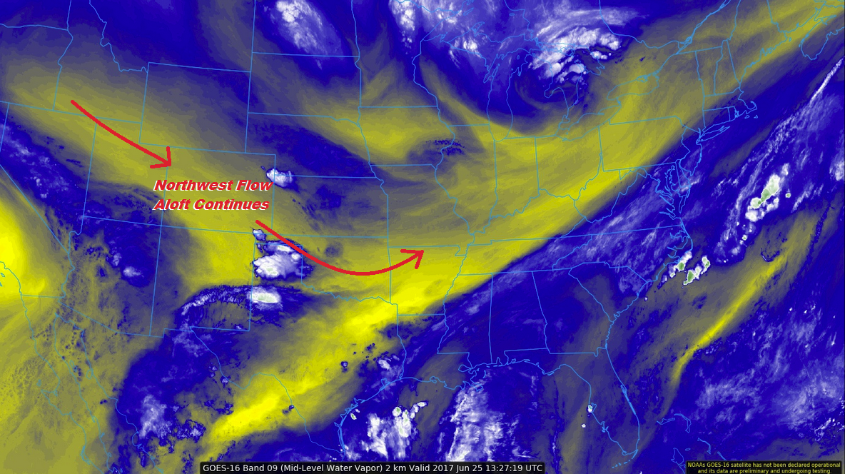
There isn’t *much* change from yesterday’s forecast in the general sense, as northwest flow aloft continues across the state, while low-level easterly flow holds moisture into eastern Colorado. Drilling down to the details, however, shows a slightly weaker cap in place around 700-600 mb. This will allow for a few more storms to fire (compared to yesterday), along and east of the Continental Divide. The greatest storm coverage will occur across the southern Front Range/Urban Corridor, Southeast Mountains, Raton Ridge, and Southeast Plains, where the best moisture resides and is in closest proximity to a mid-level shortwave expected to rotate across New Mexico. A low-end, low flood threat has been issued due to the chance for isolated strong-to-severe storms capable of producing brief periods of heavy rainfall. More isolated activity will occur across the northern Front Range, Urban Corridor, Palmer Ridge, Northeast Plains, and eastern portions of the Northern Mountains and Central Mountains.
Elsewhere across western Colorado, today’s forecast is nearly identical to yesterday’s forecast. Most areas will be basking in sunshine, with only a few cumulus clouds developing over the higher terrain as the afternoon heats up. The San Juan Mountains and San Luis Valley will have a few isolated showers/thunderstorms develop during the afternoon and evening hours, moving southeast with time into New Mexico. Moisture is fairly limited in these regions, so no flood threat is warranted.

Zone-Specific Forecasts:
Front Range, Southeast Mountains, Urban Corridor, Palmer Ridge, Northeast Plains, Southeast Plains and Raton Ridge:
Isolated-to-scattered showers/thunderstorms are expected today, with the greatest relative storm coverage over the southern Front Range/Urban Corridor, Southeast Mountains, Raton Ridge, and Southeast Plains. In general, storms will not produce rain rates capable of flash flooding, but a couple of isolated strong-to-severe storms will be capable of producing periods of heavy rain. Thus, a low flood threat has been issued. Maximum rain rates are as follows:
Front Range: 0.6-1.2 inches/hour
Urban Corridor, Palmer Ridge, and Northeast Plains: 1.0-1.5 inches/hour
Southeast Mountains: 1.0-1.25 inches/hour
Raton Ridge and Southeast Plains: 1.5-2.0 inches/hour
Timing: 1 PM – 11 PM, with a few lingering showers/storms into the morning hours
Northern Mountains, Central Mountains, San Juan Mountains, and San Luis Valley:
Isolated showers/storms are expected over eastern portions of the Northern Mountains and Central Mountains (Continental Divide), as well as over the San Juan Mountains and San Luis Valley. Western portions of the Northern Mountains and Central Mountains are expected to remain dry. Maximum rain rates are as follows:
Northern Mountains and Central Mountains: 0.3-0.5 inches/hour
San Juan Mountains: 0.3-0.6 inches/hour
San Luis Valley: 0.4-0.8 inches/hour
Timing: 1 PM – 10 PM
Southwest Slope, Northwest Slope, and Grand Valley:
Plenty of sunshine and warm temperatures will bring a pleasant end to the weekend. A few fair-weather cumulus clouds will develop over the higher terrain during the afternoon/evening hours, resulting in nothing more than shade from the sun.