Issue Date: Friday, June 23rd, 2017
Issue Time: 8:25AM MDT
— Flooding is NOT expected today
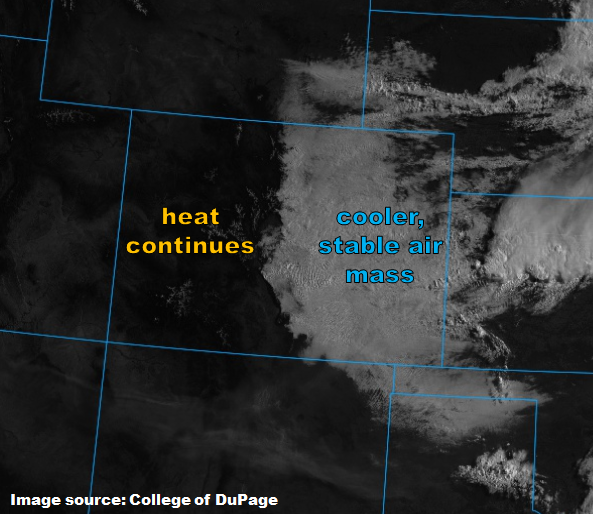
It is a tale of two weather patterns today, as easily seen in the visible satellite image, below. To the east of the Continental Divide, a stable air mass punctuated by a low cloud deck is firmly entrenched. Even with the high June sun, instability this afternoon will be slim to none as the clouds act as a barrier to insolation. To the west, clear skies are seen with temperatures cooling off to just above seasonal normal. A few showers will be likely mainly across southeast Colorado today. A week thunderstorm will be possible along the Sangre de Cristo mountains and northern San Luis Valley. However, flooding is NOT expected today.
With only limited rainfall expected, the Arkansas River below Pueblo Dam is expected to stay at current levels, just under Minor flood stage. Thus, the low flood threat has been removed there.
Today’s Flood Threat Map
For more information on today’s flood threat, see the map below (hover over threat areas for more details). For Zone-Specific forecasts, scroll below the map.

Zone-Specific Forecasts:
Southeast Plains, Northeast Plains, Urban Corridor, Front Range, Palmer Ridge, San Luis Valley, Southeast Mountains:
Mostly cloudy and much cooler today with scattered showers and perhaps a weak thunderstorm possible especially over southern areas. Max 1-hour rainfall up to 0.5 inches. Flooding is not expected today.
Primetime: 11AM to 6PM
Grand Valley, Northwest Slope, Northern Mountains, Central Mountains, Southwest Slope, San Juan Mountains, Raton Ridge:
Mostly sunny and slightly cooler today. The gusty winds observed yesterday are expected to subside today, and the Red Flag warning has expired.