Issue Date: Thursday, June 22nd, 2017
Issue Time: 10:40AM MDT
— LOW flood threat for Northeast Plains, Urban Corridor, Front Range, Palmer Ridge, Southeast Plains
— LOW flood threat for the Arkansas River downstream of Lake Pueblo (Pueblo Dam)
— An afternoon forecast update may be issued today
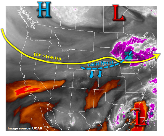
A strong surface high pressure system will be moving across the Northern Rockies today, accompanying a southward moving cool front (see water vapor image below). The front is currently on the WY/CO border and will move across eastern Colorado throughout the day, stalling near the NM border later this evening. The front will bring about a significant drop in temperatures statewide, but especially east of the Continental Divide. Accompanying the drop in temperatures will be a period of time starting this afternoon through late this evening with a noticeable increase in low-level moisture.
With plenty of morning sunshine, the atmosphere will turn unstable later this morning and into the afternoon hours. Expect a round of shower and thunderstorm activity over northeast Colorado this afternoon, slightly after peak heating. Large hail up to 1.5 inches and gusty winds will be possible with these storms.
Things continue to stay interesting into the evening and early overnight hours as guidance is in good agreement that another surge of moist upslope flow will impinge on northeast Colorado. Isolated heavy rainfall will continue to be possible through the overnight hours as instability is maintained. In all, a Low flood threat has been posted for large parts of eastern Colorado.
Finally, the Arkansas River continues to run high below Canon City. Of particular concern is the stretch downstream of Lake Pueblo (Pueblo Dam) where high reservoir levels, and expectation of future snow-melt related inflows, are causing extra releases. Also exacerbating the threat is the potential additional precipitation this afternoon. A Low flood threat has been posted.
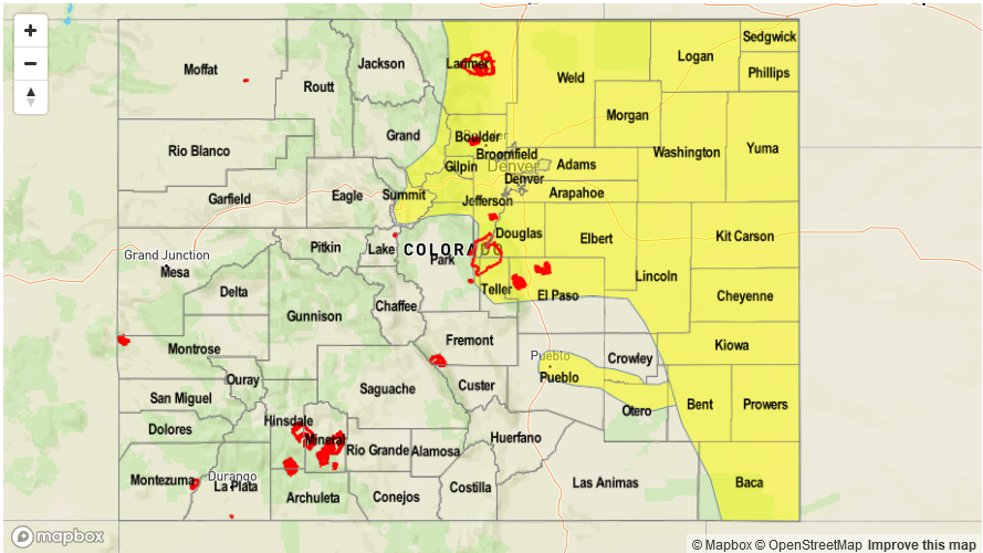
Today’s Flood Threat Map
For more information on today’s flood threat, see the map below (hover over threat areas for more details). For Zone-Specific forecasts, scroll below the map.

Zone-Specific Forecasts:
Southeast Plains, Northeast Plains, Urban Corridor, Front Range, Palmer Ridge:
Sunny early then partly to mostly cloudy and cooler with several rounds of showers and storms starting this afternoon, lasting into the overnight hours. Max 1-hour rain rates will be 1.2 inches closer to the foothills to 1.9 inches farther east. Large hail up to 1.5 inches and gusty winds could accompany the strongest cells. Heavy rainfall chances will persist into the overnight hours as moist upslope flow continues.
Primetime: 2PM to 3AM
Grand Valley, Northwest Slope, Northern Mountains, Central Mountains, Southwest Slope, San Juan Mountains, Raton Ridge, Southeast Mountains, San Luis Valley:
Mostly sunny and slightly cooler today with isolated to showers and a weak thunderstorm possible especially for northern areas. Max 1-hr rainfall up to 0.4 inches. Flooding is not expected today. A Red Flag Warning is in effect for far western areas this afternoon. Dry lightning could also exacerbate the fire threat.
Primetime: 1PM to 8PM