Issue Date: Wednesday, June 21st, 2017
Issue Time: 11AM MDT
— LOW flood threat for Southeast Plains
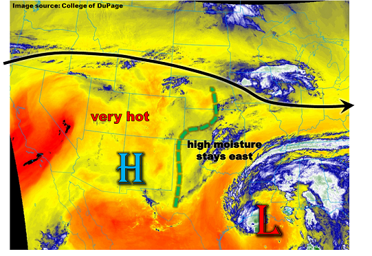
Today’s low-level water vapor image, below, shows a rather disorganized picture with pockets of moisture noted underneath the strong Great Basin high pressure ridge. A strong jet stream was noted north of Colorado, supporting a surface low pressure across eastern Wyoming and into South Dakota. This will provide northeast Colorado with downsloping flow, contributing to one more day of intense heat. A secondary area of surface low pressure was noted in southeast Colorado. Very similar to yesterday, this will allow for a focal point for afternoon shower and storm activity in the far southeast part of the state. With plenty of instability expected, heavy rainfall will be a threat. Furthermore, parts of Baca County received over 1 inch of rain yesterday, implying that additional rainfall here will cause for enhanced runoff compared to dry soil. A Low flood threat has been posted for the region. Large hail, up to 1.75 inches, will also be a possibility.
Elsewhere, limited instability will support isolated to scattered storms across the northern half of the state. However, the instability profile and storm motion together suggest only light rainfall amounts. Gusty winds will also accompany the strong cells.
Riverine-wise, the Roaring Fork upstream of Aspen continues to recede though this is being mitigated by extra flow from closure of a diversion tunnel; flooding is not expected here. The Arkansas River is running at elevated levels upstream of La Junta. However, without additional precipitation, we do foresee a flood threat.
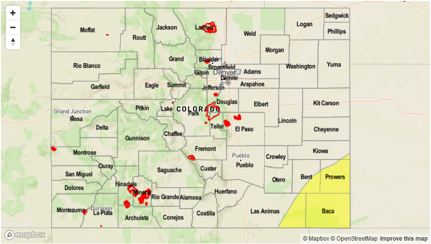
Today’s Flood Threat Map
For more information on today’s flood threat, see the map below (hover over threat areas for more details). For Zone-Specific forecasts, scroll below the map.

Zone-Specific Forecasts:
Southeast Plains, Raton Ridge, Southeast Mountains, San Luis Valley:
Becoming partly cloudy, continued hot with scattered to numerous showers and thunderstorm during the afternoon and evening. Highest chances will be over the far southeast parts of the area, close to KS, OK, NM border. Max 1-hour rainfall up to 0.7 inches except up to 2 inches far southeast where a Low flood threat has been posted. Isolated flash flooding, field and road flooding is possible. Large hail, up to 1.75 inches, could accompany the strongest cells. Parts of Baca County received heavy rainfall on Tuesday, so enhanced runoff is likely there, contributing to the Low threat.
Primetime: 1PM to 8PM
Northeast Plains, Urban Corridor, Front Range, Palmer Ridge:
Becoming partly cloudy and continued hot with isolated to scattered showers and thunderstorms forming in the mid-afternoon, lasting through the evening. Max 1-hr rainfall 0.4 inches, except up to 0.8 inches for far eastern areas. Gusty winds up to 50mph could accompany the strongest cells. Flooding is not expected today.
Primetime: 2PM to 10PM
Grand Valley, Northwest Slope, Northern Mountains, Central Mountains, Southwest Slope, San Juan Mountains:
Mostly sunny and continued very hot today isolated to scattered showers and weak thunderstorms especially for northern areas. High temperatures approaching or exceeding 100F for most locations below 4,500 feet. A Heat Advisory is in effect for parts of the Colorado River valley. Flooding is not expected today.
Primetime: 1PM to 8PM