Issue Date: Monday, June 12th, 2017
Issue Time: 3PM MDT
Valid Dates: 6/13-6/27
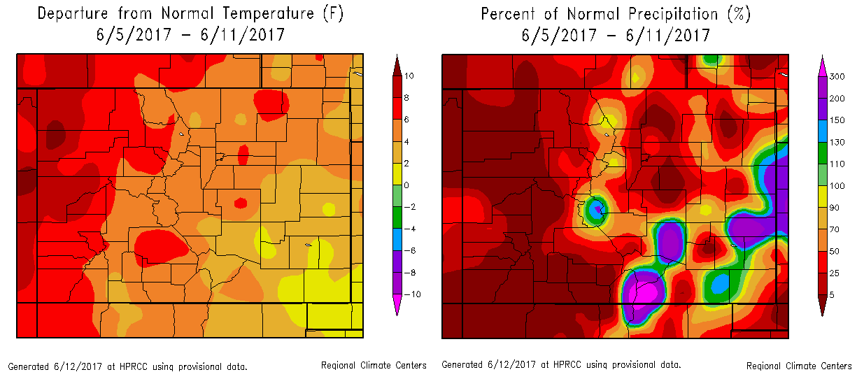
Colorado’s weather pattern has certainly taken a big step towards the quiet side, compared to the active period experienced towards the end of May and early June. The last 7 days, see below, have seen below normal rainfall (especially west of the Continental Divide [CD]) and slightly-to-much above normal temperatures statewide. While there have been many days with precipitation, the rainfall has been very streaky – arising from individual thunderstorm cells that do not cover much real estate.
Looking at the water vapor image, below, we expect similar conditions over the next 15 day period that is covered by this Flood Threat Outlook. Over the Pacific, an elongated and unusually strong (as measured by wind speed) jet stream is stretched out, nearly reaching the coast of North America. A strong low pressure is located over the Great Basin, but its effects on Colorado will be mainly limited to gusty winds, and elevated fire threat conditions in western areas. Precipitation will be limited to non-existent as dry air takes over the entire state by tomorrow (Tuesday, 6/13). In fact, this pool of dry air will be a staple over an area from the Gulf of California, northward through southwest Canada. This will keep western Colorado very dry over the next 15 days. In fact, it is possible that little to no measurable rain falls west of the Continental Divide. Although water supply will remain in good shape, simply from it being so early in the summer, we continue to expect the fire danger to stay elevated. With snow melt concluding for most areas over the next few days, it is highly likely that more fires will occur especially over the next week.
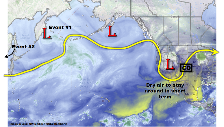
The next precipitation event on the horizon is currently located in the far northwest Pacific but will race into North America’s west coast by the end of this week. However, with little to no return moisture and quick movement, we expect only isolated and short-lasting heavy rainfall with this event. Thereafter, another disturbance that is currently not even shown on the water vapor image, will affect our weather. It will also likely come in from the northwest and its rapid movement will prevent organized heavy rainfall activity, though isolated downpours will certainly be possible especially across the eastern border.
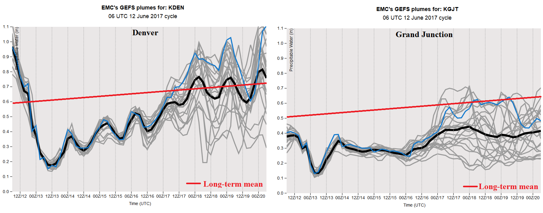
Overall, the Precipitable Water (PW) forecast plumes for the GFS ensembles, shown below, capture the essence of the next 7-10 days. For Denver, note that PW is expected to recover to near seasonal normal, though there is a very large spread in guidance. However, for Grand Junction, PW will remain suppressed through nearly the entire 15-day period. Thus, any precipitation chances will be limited to eastern Colorado, and there a flood threat is not warranted at this time.
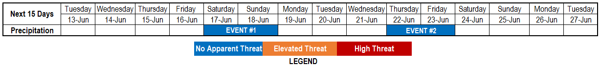
 Below we describe each of the two identified precipitation events in more detail.
Event #1: Saturday (6/17) and Sunday (6/18)
Isolated, short-term heavy rainfall possible but No Anticipated Flood Threat
The disturbance responsible for Event #1 will move across Colorado, but likely stay to the north. It is likely that there will be frontal features associated with the upper-level dynamics. Thus, isolated thunderstorm activity appears likely both in the foothills and higher elevations, as well as east towards the Kansas border. However, at this time, we do not anticipate total rainfall to exceed 1 inch, and thus a flood threat is not foreseen.

Event #2: Thursday (6/22) and Friday (6/23)
No Anticipated Flood Threat as ridge to the northwest means downsloping flow
After a break of a few days that will feature a ridge reasserting dominance over Colorado, another disturbance will graze the northern part of the state by the end of the following week. There may be more moisture available with this disturbance. However, its motion will be swift and organized thunderstorm activity does not appear likely. Spotty, short-duration heavy rainfall will be possible, especially favoring foothills and higher elevations of central and southern Colorado. However, just like with Event #1, we do not expect more than 1 inch of rainfall as the disturbance moves through.