Issue Date: 6/11/2017
Issue Time: 8:25 AM
A LOW FLOOD THREAT HAS BEEN ISSUED FOR PORTIONS OF THE FRONT RANGE, PALMER RIDGE, URBAN CORRIDOR, AND NORTHEAST PLAINS.
AREA STREAMS WILL CONTINUE TO RUN HIGH AND FAST DUE TO RAPID SNOWMELT.
ELEVATED FIRE DANGER FOR WESTERN AND CENTRAL COLORADO.
Another day of warm and mainly dry conditions is expected statewide, with fire danger being elevated (once again) across western Colorado. With the warm and dry air in place aloft, mostly sunny skies will rule the day. However, moisture is expected to make a return to northeast Colorado behind a cool front (pictured below) as upslope flow returns later this afternoon/evening.
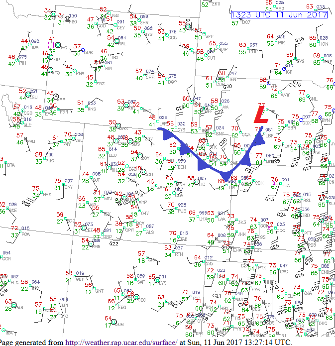
Due to this, isolated thunderstorms cannot be ruled out across the Front Range, Urban Corridor, Northeast Plains, and Palmer Ridge later this afternoon and into the evening hours. It will be difficult for storms to form due to strong capping aloft, but if they do form, they will hold the potential for large hail and strong winds, and periods of heavy rainfall. Thus, a low flood threat has been hoisted. For more details on timing/rain rates, please see the zone-specific forecast discussions below.
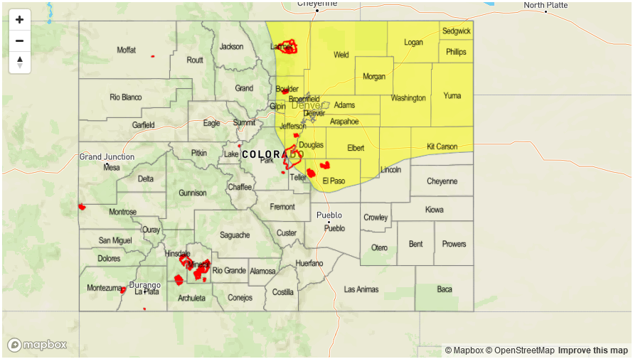
Today’s Flood Threat Map
For more information on today’s flood threat, see the map below (hover over threat areas for more details). For Zone-Specific forecasts, jump below the map.

Zone-Specific Forecasts
Front Range, Urban Corridor, Palmer Ridge, and Northeast Plains:
Mainly dry and mostly sunny with highs a couple degrees cooler than yesterday’s readings. Moisture will return to the regions by late this afternoon and attempt to fuel isolated showers/thunderstorms during the late afternoon, evening, and nighttime hours. The warm air aloft has created a stout cap that any storm activity must overcome, so nothing more than a low flood threat is warranted. Maximum rain rates will be:
Front Range: 0.8-1.2 inches/hour
Urban Corridor and Palmer Ridge: 1.0-1.5 inches/hour
Northeast Plains: 1.5-2.0 inches/hour
Southeast Plains and Raton Ridge:
Dry and warm underneath mostly sunny skies will be the name of the weather game today. Snowmelt will continue to cause area streams to run high and fast, with the Arkansas River remaining near minor flood stage across the Southeast Plains. High temperatures will be near yesterday’s readings.
Northern Mountains, Central Mountains:
Mainly dry and warm conditions are expected, with high temperatures near yesterday’s readings – perhaps a degree or two cooler. An isolated shower/weak thunderstorm cannot be ruled out for eastern portions of these regions, but chance of occurrence is low (20%). Rain rates from any development won’t pose a flood threat, as maximum rates will be 0.15-0.3 inches/hour.
Timing: 3 PM – 9 PM
Southwest Slope, Southeast Mountains, Northwest Slope, Grand Valley, San Juan Mountains, and San Luis Valley:
Mostly sunny and warm again today, with high temperatures near yesterday’s readings. Breezy/gusty winds will keep fire weather concerns elevated, with Red Flag Warnings issued for a large portion of western Colorado. Please visit your local NWS office website for more details.