Issue Date: Thursday, June 8th, 2017
Issue Time: 9AM MDT
Abnormally moist air has been a staple in Colorado’s weather for the past 96 hours, causing numerous rounds of daily showers and storms despite otherwise unimpressive atmospheric conditions. This will abruptly end as a strong disturbance enters the west coast of North America, being aided by a powerful jet stream and very dry conditions especially in the lower levels of the atmosphere. This will cause a multi-day period of very warm weather statewide with high temperatures of 10-15F above normal. An elevated fire danger is likely from Friday (6/9) through Sunday (6/11) especially west of the Continental Divide due to the combination of low relative humidity, prolonged warm weather and gusty winds.
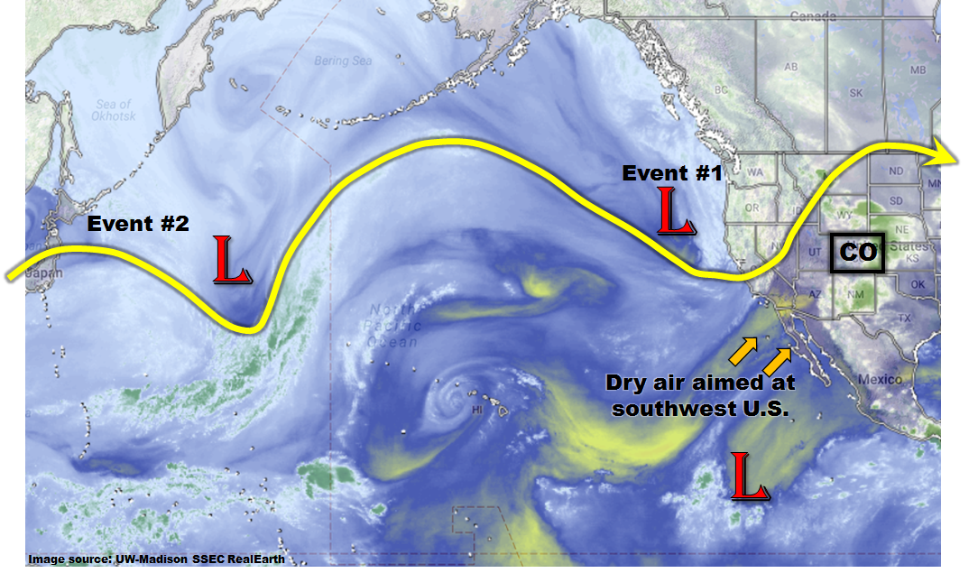
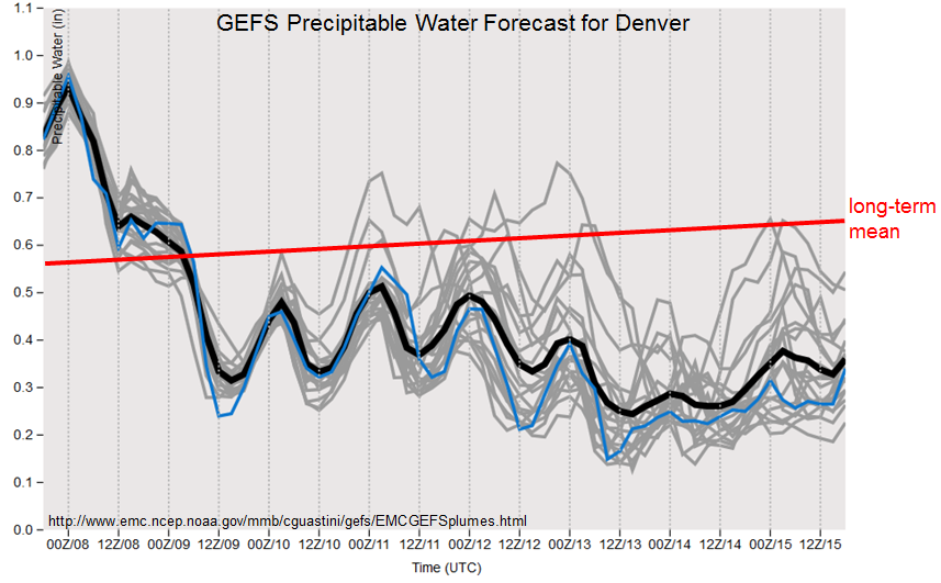
Despite some moisture return at the tail end of Event #1 (see precipitable water forecast for Denver, shown below), it now appears that there simply will not be enough moisture to generate heavy rainfall. Its main sensible impact will instead be a return to cooler conditions. The next disturbance on the horizon is currently over the western Pacific Ocean. It will arrive in the northern branch of the jet stream. Its impact will largely be conditioned on the low-level moisture supply. At this time, it appears that precipitable water will stay below about 0.7 inches, even in far eastern areas of the state. Thus, no flood threat is currently expected.
Finally, we are making one final mention of the state’s snowpack, as the majority of snow melt will be concluding this weekend. While there are some creeks that are at elevated levels (e.g. Cache La Poudre in the Front Range or the Gunnison River), without any substantial precipitation we expect snow-melt dominated rivers to begin to subside starting next week.
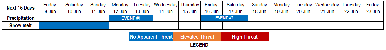
Below we describe each of the two identified precipitation events in more detail.
Event #1: Monday (6/12) and Tuesday (6/13)
Event downgraded to No Anticipated Flood Threat as low-level moisture will be absent
Expect some scattered showers and perhaps a weak thunderstorm, first in the Northern Mountains on Monday, and then spreading to eastern Colorado on Tuesday. Precipitation amounts are likely to stay below 0.5 inches.
Event #2: Friday (6/16) and Saturday (6/17)
No Anticipated Flood Threat as moisture recovery is uncertain
The elongated Pacific jet stream will relatively quickly bring another disturbance into North America. However, with more substantial drying expected after Event #1, it does not appear that there will be enough moisture available to warrant a flood threat. Nonetheless, daily showers and weak thunderstorms are expected on Friday and Saturday mainly along the foothills east of the Continental Divide, and also farther east towards the NE/KS border. At this time, it appears that up to an inch of rainfall may occur especially in eastern areas over the two day period. It is possible that this event will be upgraded so stay tuned to Monday’s Flood Threat Outlook.