Issue Date: Wednesday, June 7th, 2017
Issue Time: 10:25AM MDT
— MODERATE flood threat for parts of Urban Corridor and Northeast Plains
— LOW flood threat for Front Range, Palmer Ridge, Southeast Mountains, Raton Ridge and Southeast Plains
This morning’s water vapor imagery, below, continues to show Colorado positioned under a ridge axis that extends to the southwest. Although by itself this pattern is not particularly conducive to heavy rainfall, it becomes significantly more so when ample moisture is available. Such has been the case over the past 72 hours with precipitable water (PW) values exceeding 0.7 inches east of the Continental Divide. This morning’s surface analysis shows that surface dew point temperatures are now approaching 60 F across parts of northeast Colorado. Meanwhile, PWs range from 0.7 to just under 1 inch and are expected to gradually increase through the afternoon as moist easterly flow is advected upslope in the lowest 3-5K feet of the atmosphere. Another feature noted on water vapor imagery is the presence of a weak disturbance centered over the CO/WY border. This will move southeastward and sustain higher mid-level shear (surface-500mb exceeding 30 kts) than has been observed in the past few days, which is more conducive for maintaining an updraft and thus, heavy rainfall. Acting against the heavy rainfall threat is the large-scale subsidence from the ridge, which will continue to limit heavy rainfall coverage.
In all, we expect a similar evolution in today’s weather as the past 2-3 days. Higher elevation storms will develop east of the Continental Divide shortly before noon, then expand south and east into the Plains. A broad Low flood threat has been issued for most of eastern Colorado for the risk of isolated flash flooding. However, a Moderate threat has been posted for parts of northeast Colorado due to the region of higher shear that will support longer-lived storms and potentially storm training. Hail up to 1.75 inches is possible with these strongest cells.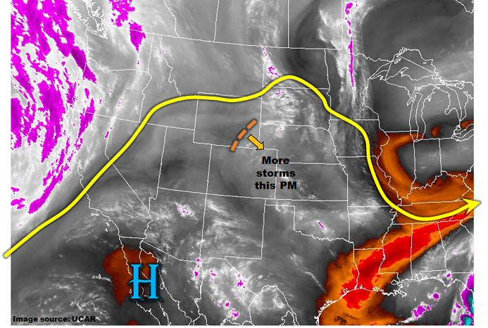
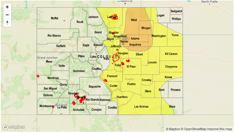
Today’s Flood Threat Map
For more information on today’s flood threat, see the map below (hover over threat areas for more details). For Zone-Specific forecasts, scroll below the map.

Zone-Specific Forecasts:
Front Range, Urban Corridor, Palmer Ridge, Raton Ridge, Southeast Mountains, Northeast Plains, Southeast Plains:
Mostly clear this morning then partly to mostly cloudy with scattered showers and thunderstorms developing shortly before noon. Storms will form over the higher terrain first, then move into lower elevations. Highest coverage will initially be in the foothills, then farther east, especially over the Urban Corridor and Northeast Plains. Max 1-hour rainfall up to 1.1 inches for most locations, but up to 2.1 inches in the Northeast Plains where higher shear will support longer-lived storms. Max 3-hour rainfall up to 3.1 inches is possible due to multiple storms passing through a given locale. A Moderate flood threat has been posted for parts of the region, with a Low flood threat elsewhere. Hail up to 1.75 inches could accompany the strongest cells in the Moderate threat region.
Primetime: 12PM to 10PM
Grand Valley, Northwest Slope, Northern Mountains, Central Mountains, Southwest Slope, San Juan Mountains, San Luis Valley:
Sunny this morning then becoming partly cloudy with isolated showers and a weak thunderstorms developing by early afternoon over the higher elevations. Max 1-hour rainfall up to 0.4 inches. Flooding is not expected today.
Primetime: 11:30AM to 7PM