Issue Date: Tuesday, June 6th, 2017
Issue Time: 10:45AM MDT
— MODERATE flood threat for parts of Urban Corridor, Front Range, Palmer Ridge and Southeast Plains. Flooding threat to persist into the late evening hours.
— LOW flood threat for parts of the Northeast Plains, Raton Ridge, Southeast Mountains
— Afternoon update may be required today
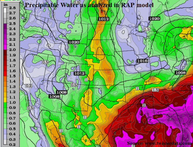
A tale of two atmospheres continues today, with a moist atmosphere residing east of the Continental Divide while a dry, hot atmosphere is found to the west (see morning precipitable water analysis by RAP model, below). Not surprisingly, this provides insight into today’s heavy rainfall chances. With a center of high pressure continuing to provide a return flow of moist air to eastern areas, expect a similar evolution today as was observed on Monday. A slight difference will be the entrance of a cool front into northeast Colorado that will likely lower or eliminate storm chances by bringing in a more stable airmass. Farther south and west, At least one round of showers and thunderstorms will develop over the higher terrain east of the Continental Divide, and then spread south and eastward with the steering winds. Moisture content will be even higher than on Monday, with precipitable water values approaching or exceeding 0.9 inch even in the foothills. With sufficient instability in place due to the strong June sunshine (CAPE exceeding 1,500 J/kg), expect scattered to numerous storms to produce heavy rainfall and also be capable of producing isolated flash flooding. A Low flood threat has been posted for most of eastern Colorado. However, a Moderate flood threat is in place for some areas where multiple rounds of storms could pose a higher flooding threat. Hail up to 1.25 inches could accompany the strongest storms.
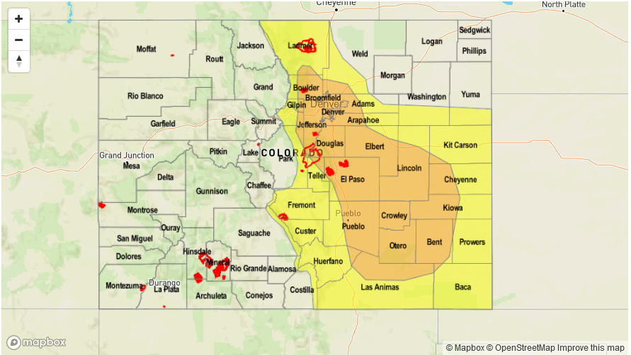
Today’s Flood Threat Map
For more information on today’s flood threat, see the map below (hover over threat areas for more details). For Zone-Specific forecasts, scroll below the map.

Zone-Specific Forecasts:
Front Range, Urban Corridor, Palmer Ridge, Raton Ridge, Southeast Mountains, Northeast Plains, Southeast Plains:
Mostly clear this morning then partly to mostly cloudy with scattered showers and thunderstorms developing shortly before noon. Storms will form over the higher terrain first, then move into lower elevations. Highest coverage will initially be in the foothills, then farther east, especially over the Palmer Ridge. Max 1-hour rainfall up to 1.1 inches for most locations, but up to 2.4 inches for parts of the Palmer Ridge where the highest instability and best upslope flow will be. Max 6-hour rainfall up to 3.6 inches is possible due to multiple storms passing through a given locale. A Moderate flood threat has been posted for the Palmer Ridge, with a Low flood threat has been posted for other parts of the region. The flood threat will persist into the late evening hours for the Front Range as upslope unstable flow could spark off additional thunderstorms.
Primetime: 11:30AM to midnight
Grand Valley, Northwest Slope, Northern Mountains, Central Mountains, Southwest Slope, San Juan Mountains, San Luis Valley:
Sunny this morning then becoming partly cloudy with isolated showers and a weak thunderstorms developing by early afternoon over the higher elevations. Max 1-hour rainfall up to 0.5 inches. Flooding is not expected today.
Primetime: 11:30AM to 7PM