Issue Date: Friday, June 2nd, 2017
Issue Time: 10:30AM MDT
— MODERATE flood threat for parts of Northeast Plains and Southeast Plains
— LOW flood threat for parts of Urban Corridor, Front Range, Palmer Ridge, Southeast Mountains, and Raton Ridge
— An update to the Flood Threat Bulletin is possible this afternoon, depending on how conditions evolve.
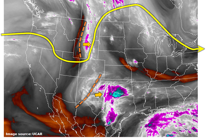
The steady increase of moisture continues today across Colorado. Precipitable water (PW) values are now in the 0.7 – 1.0 inch range east of the Continental Divide and 0.5 – 0.7 inches to the west. As the water vapor image shows, below, there are two disturbances that will favor upward motion, and contribute to heavy rainfall chances. The first disturbances is easily seen extending from Montana to Utah. This will continue to move E/SE today and generate late morning storms across the Front Range, spreading south and east through the day. The second disturbance is farther south in New Mexico. As this slowly moves east, it will continue to favor showers and storm chances across southern Colorado. A large area east of the Continental Divide will be under a Low flood threat today for isolated flash flooding. Near the Kansas border, a small area has been placed under a Moderate flood threat due to higher chances of flash flooding as well as relatively high antecedent moisture. The South Fork of the Republican River and Beaver Creek (Kit Carson County) should be watched for flooding later today. As such, an afternoon update is possible for the Flood Threat Bulletin.
Today’s Flood Threat Map
For more information on today’s flood threat, see the map below (hover over threat areas for more details). For Zone-Specific forecasts, scroll below the map.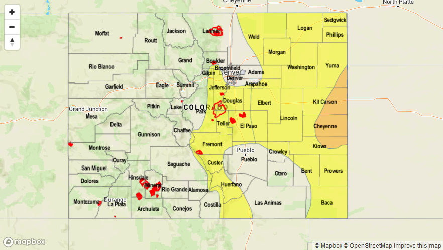

Zone-Specific Forecasts:
Southeast Plains, Northeast Plains:
Mostly sunny this morning then mostly cloudy with several rounds of showers and thunderstorms likely this afternoon. Max 1-hour rainfall up to 2.4 inch, max 3-hour rain up to 3.4 inches. Gusty winds up to 60mph could accompany the strongest storms. Isolated flash flooding, field and road flooding is likely. Riverine flooding on the Republican (South Fork) River and Beaver Creek is possible. A Moderate flood threat has been posted for part of the region with a Low threat elsewhere.
Primetime: 2PM to 10PM
Front Range, Urban Corridor, Palmer Ridge, Raton Ridge, Southeast Mountains, San Juan Mountains, San Luis Valley:
Mostly clear this morning then partly to mostly cloudy with scattered showers and thunderstorms developing by noon. Storms will form over the higher terrain first, then move into lower elevations. Highest coverage will be in the foothills southwest of Denver. Max 1-hour rainfall up to 1.2 inches. A Low flood threat has been posted for parts of the region for isolated flash flooding. All fire scars in the area should be watched for excessive runoff today.
Primetime: 12PM to 8PM
Grand Valley, Northwest Slope, Northern Mountains, Central Mountains, Southwest Slope:
Sunny this morning then becoming partly cloudy with scattered showers and weak thunderstorms developing by early afternoon. Max 1-hour rainfall up to 0.7 inches. Small hail, up to 0.5 inches, could accompany the strongest cells. Flooding is not expected today.
Primetime: 11AM to 7PM