Issue Date: Thursday, June 1st, 2017
Issue Time: 10:15AM MDT
— LOW flood threat for parts of Front Range, Palmer Ridge, Southeast Mountains, Central Mountains, San Juan Mountains and Raton Ridge
Another mostly sunny morning has greeted most of Colorado, a foreshadowing of the warm day to come. Meanwhile, moisture has continued to increase across the state over the past 24-48 hours. This morning, precipitable water (PW) values are greater than 0.5 inch for almost everyone, with eastern Colorado seeing values closer to 0.8 inches. Low-level moisture will continue to slowly increase as the diurnal circulation, favoring weak easterly upslope flow, keeps advecting higher moisture into our state. By this afternoon, expect PW values to be at or above 0.7 east of the Continental Divide.
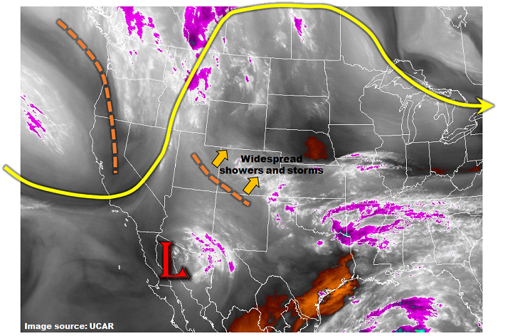
Looking at the water vapor image, below, reveals a cutoff low centered over northwest Mexico. Also (loosely) associated with this feature is a disturbance that is currently position near the Four Corners, moving slowly northeastward. This will provide large-scale upward motion, increasing shower and storm chances across western and central Colorado. Instability will be present today across most of the state, but highest chances of precipitation are limited to western and central areas. West of the Continental Divide, rainfall rates will be just below flood threat levels. However, in the foothills south of Denver all the way through the New Mexico border, there will be the potential for at least isolated heavy rainfall capable of causing flash flooding. A Low flood threat has been posted for this region.
Today’s Flood Threat Map
For more information on today’s flood threat, see the map below (hover over threat areas for more details). For Zone-Specific forecasts, scroll below the map.


Zone-Specific Forecasts:
Front Range, Urban Corridor, Palmer Ridge, Raton Ridge, Southeast Mountains, San Juan Mountains, San Luis Valley:
Mostly clear this morning then partly to mostly cloudy with scattered showers and thunderstorms developing by early afternoon. Storms will form over the higher terrain first, then move into lower elevations. Highest coverage will be in the foothills southwest of Denver. Max 1-hour rainfall up to 1.1 inches. A Low flood threat has been posted for parts of the region for isolated flash flooding. The Hayden Pass fire scar should be monitored today since even rainfall exceeding 0.5 inches per hour could cause excessive runoff of the sensitive soil.
Primetime: 12PM to 9PM
Grand Valley, Northwest Slope, Northern Mountains, Central Mountains, Southwest Slope:
Sunny this morning then becoming mostly cloudy with scattered to widespread showers and weak thunderstorms developing by early afternoon. Max 1-hour rainfall up to 0.8 inches. Small hail, up to 0.5 inches, could accompany the strongest cells. Gusty winds, up to 55 mph, will also be possible with stronger storms. Flooding is not expected today. Activity will subside by early evening though showers are possible into the overnight hours.
Primetime: 11AM to 8PM
Southeast Plains, Northeast Plains:
Mostly sunny this morning then partly cloudy and warm this afternoon. Isolated showers and thunderstorms are possible, especially closer to the mountains. Max 1-hour rainfall up to 1.0 inch. Hail up to 1.25 inches, and gusty winds up to 60mph could accompany the strongest storms. Flooding is not expected today.
Primetime: 2PM to 9PM