Issue Date: Monday, May 22nd, 2017
Issue Time: 10:18AM MDT
— Flooding is NOT expected today
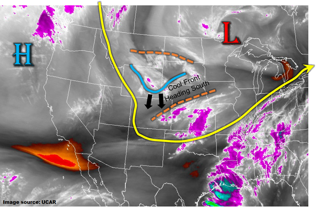
The impressive large-scale trough, centered over southwest Ontario this morning continues to rule the weather pattern in the Central Plains and Rocky Mountain states. The water vapor image, below, shows several disturbances (indicated by tan lines) rotating around the main low-pressure like spokes on a bicycle wheel. The southern disturbance is currently causing light to moderate rainfall in the Southeast Plains. In its wake, sunshine rules the land across central and northern Colorado.
The sunshine will be limited as clouds are streaming in from Wyoming. Looking ahead, it is this northern disturbance that will affect our weather this afternoon, evening and into the overnight hours. As it quickly moves south, it will cause mid-level lift, and scattered to numerous showers this afternoon and evening basically across the entire state (with perhaps slightly more coverage east of the Continental Divide). If this setup occurred later in the summertime, it could be conducive for a flood threat. However, today, moisture values are rather low with precipitable water values only in the 0.4-0.6 inch range. Thus, instability will be suppressed. Furthermore, storm motions will be swift, 35mph+, limiting rainfall in any given locale. Collectively, the best chances of a weak thunderstorm, and associated higher rainfall rates, will be in the Palmer Ridge and Southeast Plains. Even there, though, rainfall intensity will be light to moderate and a flood threat is not warranted.
A second impact of the large-scale trough is a cooler than normal atmosphere. This will promote more high-elevation snowfall. Later this evening, expect snow levels to fall below 8,000 feet once again.
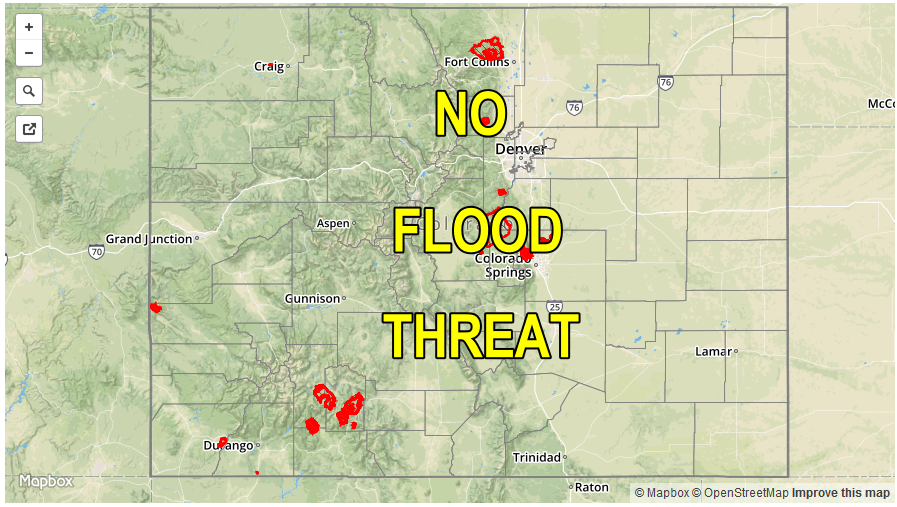
Today’s Flood Threat Map
For more information on today’s flood threat, see the map below (hover over threat areas for more details). For Zone-Specific forecasts, scroll below the map.
Zone-Specific Forecasts:
Raton Ridge, Southeast Mountains, Southeast Plains, Palmer Ridge:
Overcast with scattered showers this morning in the Southeast Plains. Expect brief clearing by early afternoon, followed by a second wave of showers and weak thunderstorms starting late this afternoon and into the overnight hours. Max 1-hour rain rates up to 0.7 inches. Max 24-hour rainfall up to 0.9 inches. Flooding is not expected today.
Primetime: 4PM to 1AM
Northeast Plains, Front Range, Urban Corridor:
Sunny early, then increasing clouds with scattered to numerous showers and perhaps a weak thunderstorm developing by early afternoon and lasting into the overnight hours. Max 1-hour rain rates of 0.5 inches per hour will be possible with max 24-hour rain amounts up to 0.75 inches. Snow level 9,000 feet lowering to 7,000 feet overnight. Flooding is not expected today.
Primetime: 2PM to 11PM
San Juan Mountains, Southwest Slope, Grand Valley, San Luis Valley, Northwest Slope, Northern Mountains, Central Mountains:
Sunny early then increasing clouds with scattered to numerous rain and snow showers starting in the north by early afternoon, then moving southward. Max 1-hour rain rates up to 0.4 inches, with max 24-hour rainfall up to 0.6 inches. Snow level 9,000 feet then lowering to 7,500 by late evening. Flooding is not expected today
Primetime: 1PM to 11PM