Issue Date: Thursday, May 18th, 2017
Issue Time: 9:00AM MDT
— Flooding is NOT expected today
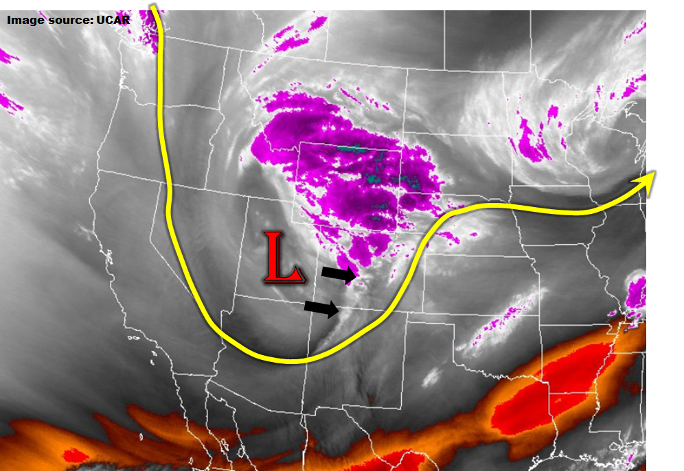
A strong low-pressure system, as easily seen on water vapor imagery (below), is quickly traversing across Colorado from west to east today. The combination of strong dynamics, an easterly moisture feed, and orographic lifting is causing widespread precipitation this morning. Yes, impressively, some of the precipitation is falling as snow even in the lower elevations. Fortunately, due to the cold nature of this system, atmospheric instability will remain near zero except for the far southeastern portion of the state. Thus, only light to moderate precipitation intensity is expected today. Flooding is not expected though poorly drained areas may see some nuisance ponding due to the long duration of the event. Even in the southeast, any storm that manages to form will move quickly to the east/northeast, limiting the rainfall in any given location.
Today’s Flood Threat Map
For more information on today’s flood threat, see the map below (hover over threat areas for more details). For Zone-Specific forecasts, scroll below the map.


Zone-Specific Forecasts:
Front Range, Urban Corridor:
Cloudy skies with light to moderate rain and higher elevation snow continuing through the day. Up to 3.5 inches of rain (or snow water equivalent) will be possible especially in the higher elevations west of a line between Boulder and the Wyoming state line. Streams and creeks are expected to near bankfull levels especially below 7,000 feet where snow turns to rain later today; however, flooding is not expected. Above 9,000 feet, heavy snow will fall, with up to 30” possible in the highest east-facing slopes north of I-70. Travel disruptions and road closures are likely. Please stay tuned to National Weather Service warnings and advisories for the latest information on key trouble areas.
Primetime: 11AM to 11AM (tomorrow)
San Juan Mountains, Southwest Slope, Grand Valley, San Luis Valley, Northwest Slope, Northern Mountains, Central Mountains:
Mostly cloudy to overcast skies with scattered to widespread showers (higher elevation snow) and perhaps a weak thunderstorm especially in the San Juans. Total 24-hour rainfall up to 1.1 inches will be possible in the favored higher elevation regions. However, rainfall intensity is expected to remain below flood threat levels. Activity will subside through the afternoon.
Primetime: 11AM to 5PM
Northeast Plains, Palmer Ridge:
Mostly cloudy skies with some clearing especially in southern and eastern areas. Scattered showers and a weak thunderstorm are expected to continue through the day. Max 1-hour rain rates up to 0.7 inches are possible, with max 24-hour totals up to 1.7 inches in far western areas. Flooding is not expected today though nuisance ponding in poorly drained areas can be expected.
Primetime: 11AM to 9PM
Southeast Plains, Raton Ridge, Southeast Mountains
Partly to mostly cloudy skies with isolated to scattered showers and a few weak thunderstorms developing by late afternoon. Max 1-hour rain rates up to 0.5 inches possible, with max 24-hour precipitation up to 1.1 inches in far northern areas or higher elevations. Flooding is not expected today.
Primetime: 1PM to 8PM