Issue Date: 5/17/2017
Issue Time: 9:45 AM
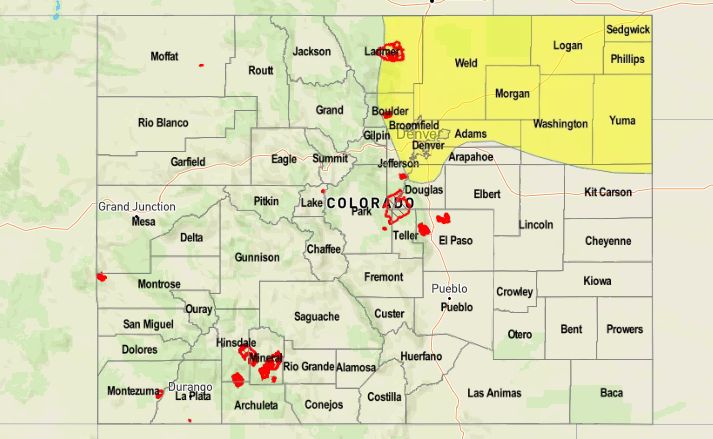
A LOW FLOOD THREAT IS FORECAST FOR PORTIONS OF THE FRONT RANGE, URBAN CORRIDOR AND NORTHEAST PLAINS. The Purgatoire River continues to run at bank-full levels, to minor flood stage, in Bent County.
A shortwave ridge between yesterday’s upper-level low and the upcoming upper-level low will provide a break in the active weather today east of the Continental Divide, but only for a brief while. Showers and thunderstorms will be on the increase for the Front Range, Urban Corridor, Northeast Plains, Palmer Ridge, and northern portions of the Southern Plains during the early afternoon. Later during the afternoon/evening hours as instability and lapse rates becomes more favorable, a few scattered thunderstorms will join the showers. These thunderstorms will continue into the overnight hours, and are the reason behind the issuance of the low flood threat. Cold air will continue to filter into the region overnight, which will drop snow levels to 7,000 feet in the mountains and foothills.
Further to the south over the Southeast Plains, Southeast Mountains, and Raton Ridge, it will be late in the evening, perhaps midnight or later, before any showers pop up. Any thunderstorms that develop in these regions will be less intense, and do not warrant any flood threat considerations. Snow levels in the mountains will be around 7-8,000 feet.
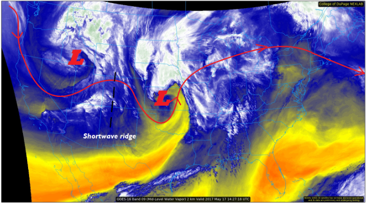
West of the Divide, showers have already began to increase due to the newest influx of moisture and atmospheric support. A few isolated thunderstorms will develop this afternoon/evening as daytime heating results in a bit of instability, but flooding rain is not expected. Snow levels during the day will be around 8-9,000 feet, dropping to around 6000 feet overnight tonight. For more information regarding timing and rain rates, please see the zone-specific forecasts below.
Today’s Flood Threat Map
For more information on today’s flood threat, see the map below (hover over threat areas for more details). For Zone-Specific forecasts, jump below the map.

Zone-Specific Forecasts
Front Range:
Scattered-to-widespread showers and an isolated thunderstorm or two are expected today/tonight, beginning just after lunchtime and continuing into the overnight hours. Snow levels will be around 9000 feet during the day, falling to around 7,000 feet overnight. Maximum rain rates from thunderstorms will be 0.8-1.2 inches/hour.
Timing: 1 PM – Midnight, with a few lingering showers into the morning hours tomorrow.
Urban Corridor, Palmer Ridge, and Northeast Plains:
Scattered showers and thunderstorms are expected to develop early this afternoon, continuing into the overnight hours. Maximum rain rates will be as follows:
Urban Corridor and Palmer Ridge: 0.8-1.2 inches/hour
Northeast Plains: 1.5-2.0 inches/hour
Timing: 1 PM – 1 AM, with a few lingering showers/thunderstorms into the morning hours tomorrow
Southeast Plains and Raton Ridge:
The upper-level ridge will hold off showers in these regions through the early afternoon, before giving way to a few showers for the rest of the period across the Southeast Plains. The Raton Ridge will remain largely dry into the morning tomorrow. Maximum rain rates will be 0.4-0.8 inches/hour for the Southeast Plains and 0.1-0.3 inches/hour for the Raton Ridge.
Timing: 4 PM – Midnight, with a few lingering showers into the early morning hours
Southeast Mountains:
The region will remain dry into the evening hours tonight, with activity perhaps holding off until midnight or later. Showers that develop will be scattered in nature, producing mainly light rain/snow. Maximum rain rates: 0.4-0.6 inches/hour
Timing: Midnight – End of Period
Northwest Slope, Northern Mountains, Central Mountains, San Juan Mountains, San Luis Valley, Southwest Slope, and Grand Valley:
Scattered to widespread showers and a couple isolated thunderstorms are expected throughout the period. Snow levels will be around 7-8000 feet during the afternoon/evening, before falling to around 6000 feet overnight tonight. Maximum rain rates are as follows: 0.3-0.6 inches/hour
Timing: Ongoing – End of Period