Issue Date: 5/16/2017
Issue Time: 9:25 AM
A LOW FLOOD THREAT IS FORECAST TODAY FOR PORTIONS OF THE NORTHEAST PLAINS AND SOUTHEAST PLAINS. The Purgatoire River continues to run at bank-full levels, to minor flood stage, in Bent County.
An upper-level trough will rotate across the region today, resulting in an unsettled day/night. The potential for heavy rainfall will be stunted by limited moisture across the high country and western slope; this morning’s precipitable water values were in the 25th percentile for the date. Those values will climb somewhat with the approach/passage of the upper-trough, but not to an extent to warrant a flood threat. For the adjacent lower elevations of the Urban Corridor, Palmer Ridge, Raton Ridge, and western portions of the plains regions, a bit better moisture will be present. Storms that form in these areas will have access to enough moisture to produce brief periods of moderate-to-heavy rainfall, but not enough to warrant a flood threat.
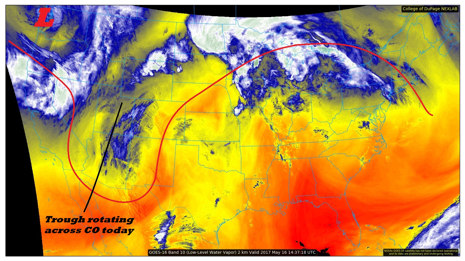
The deepest moisture (and best instability) will reside across the far eastern plains, which is where a low flood threat has been issued for today/tonight. Additionally, near/within the low flood threat, storms will be on the strong-to-severe side, with damaging winds and large hail as the main threats. An isolated tornado or two cannot be ruled out, especially across far northeastern Colorado where a surface boundary will reside. For more information regarding rain rates and timing, please see the zone-specific forecast discussions below.
Today’s Flood Threat Map
For more information on today’s flood threat, see the map below (hover over threat areas for more details). For Zone-Specific forecasts, jump below the map.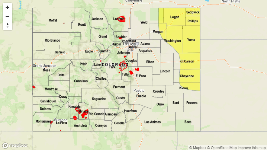

Zone-Specific Forecasts
Urban Corridor, Palmer Ridge, Northeast Plains, Southeast Plains, and Raton Ridge:
Sunny skies this morning will give way to mostly cloudy skies and scattered showers/thunderstorms this afternoon/tonight. Areas nearest the mountains will see storms produce more in the way of gusty outflow winds than rainfall due to drier air in the low- and mid-levels. Further to the east, deeper moisture is present, with dewpoints in the 40s and low 50s. These areas will hold the threat for heavy rainfall, and thus the introduction of the low flood threat. Maximum rain rates are as follows:
Urban Corridor and Palmer Ridge: 0.4-0.8 inches/hour
Northeast Plains and Southeast Plains (Kiowa/Cheyenne Counties): 1.0-1.75 inches/hour
Southeast Plains (remainder): 0.4-0.8 inches/hour
Raton Ridge: 0.1-0.3 inches/hour
Timing: 1 PM – 1 AM, with lingering showers into the morning hours
Front Range and Southeast Mountains:
Increasing clouds are expected through the day as the upper-level trough rotates through. Isolated-to-scattered showers/thunderstorms are expected to develop this afternoon across these regions, with the best coverage/duration over the Front Range. Maximum rain rates are as follows:
Front Range: 0.2-0.5 inches/hour
Southeast Mountains: 0.2-0.4 inches/hour
Timing: 1 PM – 11 PM, with a few lingering showers into the early morning hours, mainly over the Front Range
Northwest Slope, Northern Mountains, Central Mountains, San Juan Mountains, San Luis Valley, Southwest Slope, and Grand Valley:
High clouds have already begun streaming into the area, with more on the way. Scattered showers/thunderstorms are expected this afternoon and evening, with the most coverage expected over the higher terrain. Snow will fall on the mountain peaks, resulting in 1-3 inches of accumulation. Moisture is limited, so heavy rainfall is not a threat today. Maximum rain rates will be 0.2-0.4 inches/hour.
Timing: 11 AM – 9 PM, with a couple lingering showers until midnight.