Issue Date: May 10th, 2017
Issue Time: 9:45AM MDT
—MODERATE flood threat for Southeast Plains, Southeast Mountains
—LOW flood threat for Northeast Plains, Palmer Ridge, Raton Ridge, San Juan Mountains and San Luis Valley
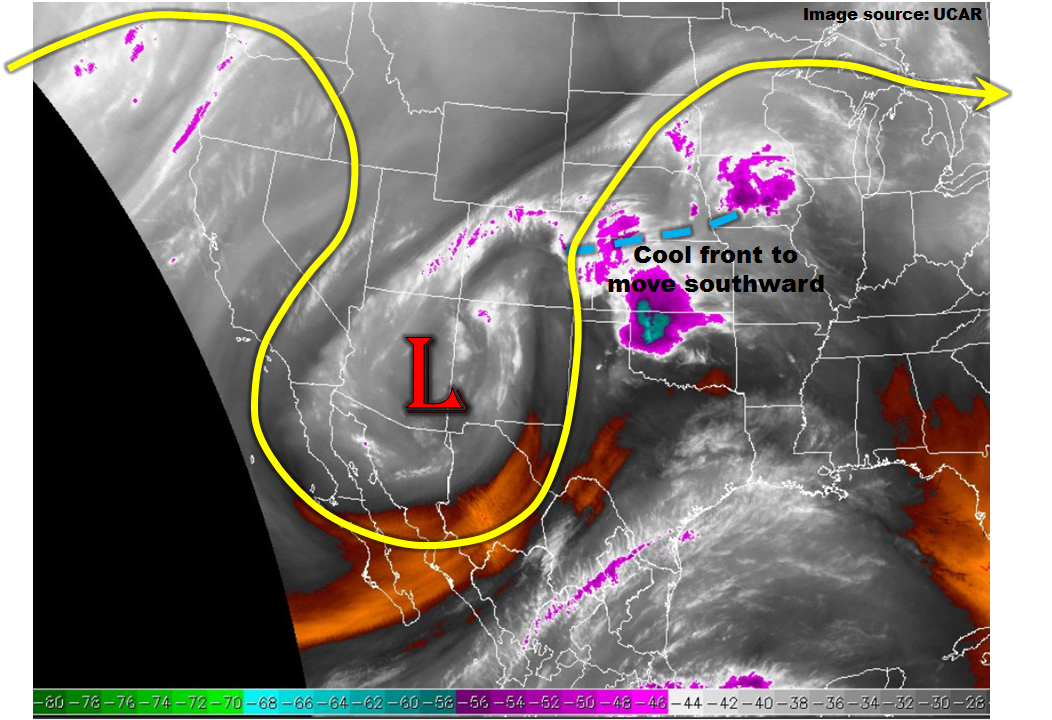
The strong upper-level low pressure system that has been slowly trekking across the southwest US will accelerate its northeast movement and move across the far southern part of our state today (see water vapor image below). Strong upper-level divergence to the northeast of the low-pressure will put nearly the entire state in a region favorable for upward motion and precipitation. In addition, the 8AM surface analysis revealed a cool front draped in a northeast-southwest fashion across northeast Colorado. Although the temperature and moisture gradients with the cool front were not particularly impressive as of this morning, this will change as sunshine boosts the warm sector temperatures later this afternoon.
The cool front is also clearly marked by a low-level cloud deck that will strongly limit heating north of its boundary. This will result in little to no instability and low rainfall rates north of the cool front. Along and south of the cool front, the combination of upper-level dynamics, plenty of early sunshine and a moist air axis being advected into southeast Colorado from the east, will result in several rounds of showers and thunderstorms. Very heavy rainfall will be possible with these storms and a low/moderate flood threat has been posted for parts of the region.
Today’s Flood Threat Map
For more information on today’s flood threat, see the map below (hover over threat areas for more details). For Zone-Specific forecasts, scroll below the map.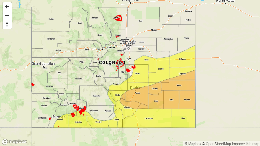

Zone-Specific Forecasts:
Southeast Plains, Palmer Ridge, Raton Ridge, Southeast Mountains
Mostly sunny early, then becoming partly to mostly cloudy with showers and thunderstorms rapidly developing by mid-afternoon. Coverage will be highest in the Southeast Plains. Very heavy rainfall will be possible with the strongest storms with max 1-hour rain rates of 2.8 inches, and max 3-hour rates up to 3.8 inches. Isolated flash flooding will be likely under the strongest storms. Riverine flooding will be possible in the tributaries of the Arkansas River. In addition, hail up to 1.5 inches will be possible, mainly along the Kansas border. A Moderate flood threat has been posted for parts of the region, with a Low flood threat for the remaining areas. Activity will last well into the evening but begin to subside prior to midnight.
The snow level will lower to about 10,000 feet by late evening with up to a foot of snow possible in the highest elevations of the Sangre de Cristos.
Primetime: 1PM to 11PM
Northeast Plains, Front Range, Urban Corridor:
Overcast this morning with some partial sunshine possible during the afternoon. Light to moderate showers and perhaps a thunderstorm will be possible through the evening hours. Max 1-hour rainfall up to 0.7 inch is possible with the strongest storm.
Primetime: 11AM to 5PM
San Juan Mountains, Southwest Slope, Grand Valley, San Luis Valley, Northwest Slope, Northern Mountains, Central Mountains:
Partly sunny skies with isolated to scattered showers and a few thunderstorms possible through the early evening. In the far southern regions, max 1-hour rainfall up to 0.9 inches is possible and a Low flood threat has been posted for mud flows and debris slides. Elsewhere, max 1-hour rain rates up to 0.5 inches will be possible. The snow level will lower to about 10,000 by late evening with a few inches possible in the higher elevations overnight.
Primetime: 1PM to 7PM