Issue Date: 5/8/2017
Issue Time: 9:40 AM
A MODERATE FLOOD THREAT IS FORECAST TODAY FOR PORTIONS OF THE URBAN CORRIDOR, FRONT RANGE, PALMER RIDGE, AND NORTHEAST PLAINS.
A LOW FLOOD THREAT IS FORECAST TODAY FOR SURROUNDING AREAS, INCLUDING PORTIONS OF THE NORTHERN MOUNTAINS, CENTRAL MOUNTAINS, SOUTHEAST MOUNTAINS, RATON RIDGE, AND SOUTHEAST PLAINS.
The upper-low, which we have discussed for a few days now, is currently spinning over southern CA/California Baja. Over the central US, the upper-level ridge is still in place, which, in concert with the upper-low, is forcing relatively moist, southerly flow over Colorado. At the surface, a cold front is pushing southward across eastern Colorado, and will stall along/near the Palmer Divide this afternoon. Sufficient instability and wind shear will also be in place across eastern Colorado. Altogether, an environment that will support a few strong/severe thunderstorms, amongst more numerous showers and garden-variety thunderstorms, is expected. The best coverage will occur along/east of the Continental Divide and out over the Plains, where moisture, low-level forcing, and upper-level support will all be most favorable.
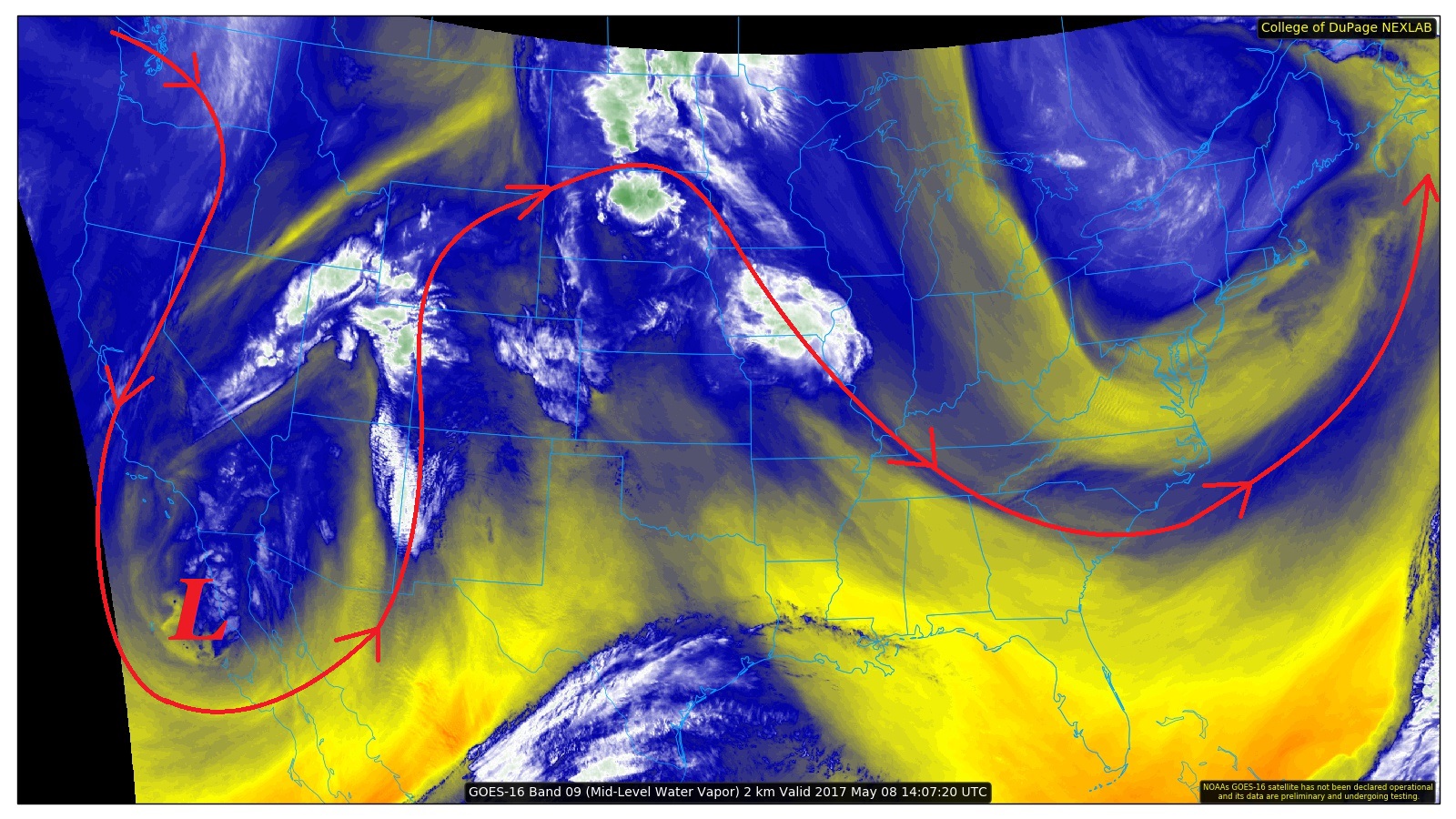
Coverage will be a bit more widely scattered across western Colorado, with the higher terrain of the Central Mountains, San Juan Mountains, and Northern Mountains being favored. Storms on the western side of the Continental Divide will have enough instability and wind shear to result in a couple stronger thunderstorms, resulting in pea-sized hail and brief periods of heavy rain. For more information on rain rates and timing, please see the zone-specific forecast discussions below.
Today’s Flood Threat Map
For more information on today’s flood threat, see the map below (hover over threat areas for more details). For Zone-Specific forecasts, jump below the map.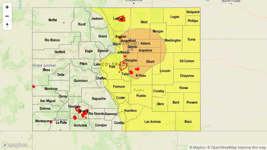

Zone-Specific Forecasts
Front Range, Southeast Mountains, Urban Corridor, Palmer Ridge, Northeast Plains, Southeast Plains, and Raton Ridge:
Scattered showers/thunderstorms are expected, and a few will be strong/severe. The main concern for today’s flood threat exists across burn scars and in urban areas where drainage is poor and there are vast impervious surfaces. Maximum rain rates are as follows:
Front Range and Southeast Mountains: 1.0-1.4 inches/hour
Urban Corridor, Palmer Ridge, and Raton Ridge: 1.0-1.75 inches/hour
Northeast Plains and Southeast Plains: 2.0-2.5 inches/hour
Timing: 1 PM – Midnight, with a few showers/thunderstorms lingering over the plains until 4 AM.
Northern Mountains, San Juan Mountains, Central Mountains, and San Luis Valley:
Scattered showers/thunderstorms are expected this afternoon and evening, with the best coverage over the higher terrain. Most storms will be fairly run-of-the-mill, producing gusty winds, lightning, and brief periods of moderate rainfall. Maximum rain rates are as follows:
Northern Mountains and Central Mountains: 0.6-1.1 inches/hour
San Juan Mountains and San Luis Valley: 0.4-0.8 inches/hour
Timing: 1 PM – 10 PM, with a few lingering showers into the early morning hours tomorrow
Northwest Slope, Southwest Slope, and Grand Valley:
Isolated-to-widely scattered showers and a couple thunderstorms are expected today. The best coverage will occur along/near the higher terrain. Most showers/storms will be garden-variety, producing gusty winds, lightning, and brief periods of moderate rainfall. Maximum rain rates are as follows:
Northwest Slope and Grand Valley: 0.4-0.7 inches/hour
Southwest Slope: 0.3-0.6 inches/hour
Timing: 1 PM – 10 PM, with a few lingering showers into the early morning hours tomorrow