Issue Date: Friday, September 23rd, 2016
Issue Time: 9:45AM MDT
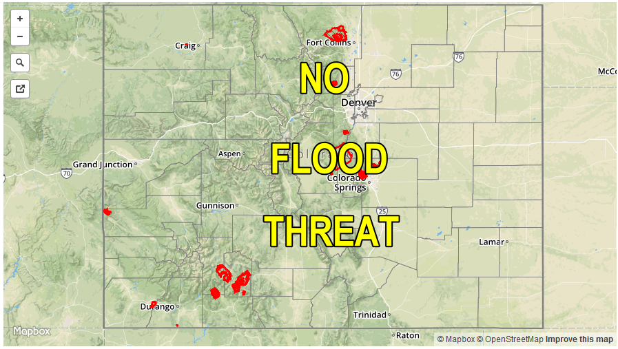
— Flooding is NOT expected today
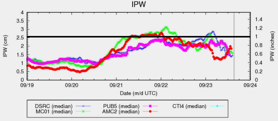
The large-scale trough continues its eastward movement across the Great Basin. As of this morning, it was centered over western Utah. However, without the support of subtropical moisture, dry air has begun to get entrained into the trough. For example, the precipitable water (PW) values over Colorado have dropped from near 1 inch on Thursday to the 0.55 – 0.8 inch range this morning. PW will likely continue to slowly decline, except for far eastern areas where south-southeasterly flow will bring in Gulf of Mexico moisture. Although widespread showers and perhaps a weak thunderstorm are expected over the western slope, rainfall intensities will be lower than Thursday with declining moisture. Instead, the highest rainfall rates today are expected across far eastern Colorado where the “warm sector” will be found. A dryline will develop across eastern Colorado late this morning and will likely serve as the focal point for a broken line of thunderstorms. With an excessive amount of unidirectional shear in place today, these storms will have a hard time keeping their updrafts intact. Thus, the heavy rainfall threat will be limited, and flooding is not expected. The more impactful weather today will be the gusty winds especially east of the Continental Divide. A Red Flag warning is in place for parts of southeast Colorado for this afternoon.
Today’s Flood Threat Map
For more information on today’s flood threat, see the map below (hover over threat areas for more details). For Zone-Specific forecasts, scroll below the map.

Zone-Specific Forecasts:
Southeast Plains, Northeast Plains, Palmer Ridge, Raton Ridge, Front Range, Urban Corridor, Southeast Mountains:
Sunny early then turning partly to mostly cloudy with scattered showers and thunderstorms developing by early afternoon. Highest storm coverage will be across far eastern areas. Max 1-hr rain rates are as follows:
Northeast Plains, Southeast Plains: 1 inch
All Other Zones: 0.5 inches
In addition to rainfall, hail up to 1.25 inches and wind gusts up to 70 mph are possible under the strongest thunderstorms. Elsewhere, gusty winds up to 45 mph with falling relative humidity will result in an elevated wildfire threat across the foothills and adjacent plains of southeast Colorado. Scattered showers will continue overnight over the Front Range, Urban Corridor and Northeast Plains. Additionally, snow levels will drop to about 10,000 feet by Saturday morning.
San Juan Mountains, Southwest Slope, Grand Valley, Central Mountains, San Luis Valley, Northwest Slope, Northern Mountains:
Mostly cloudy skies with scattered to widespread showers and a few weak thunderstorms continuing the afternoon and evening before tapering off. Highest 1-hr rain rates of 0.5 inches can be expected. Snow levels will slowly drop through the day and will get down to about 9,000 feet by late evening. Flooding is not expected today.