Issue Date: 9/22/2016
Issue Time: 9:40 AM
A LOW FLOOD THREAT IS FORECAST FOR PORTIONS OF THE NORTHWEST SLOPE, GRAND VALLEY, SOUTHWEST SLOPE, AND SAN JUAN MOUNTAINS.
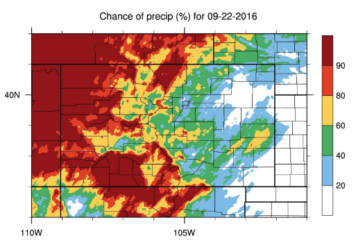
A fairly active day is in store for the High Country and Western Slope, with isolated-to-scattered showers/storms filtering across eastern Colorado. The “Chance of Precipitation” from our internal tool highlights this well (image below). The upper-level low will continue its shift into the Great Basin, bringing two major factors that are leading to the active day:
1. Increasing moisture, mainly in the low- and mid-levels, will result in greater fuel for showers/storms
2. Providing broad-scale, dynamic support for numerous showers/thunderstorms
Those two factors, paired with better instability than previous days, will lead to better shower/thunderstorm coverage, with an isolated strong/severe thunderstorm mixed in. Stronger storms will be capable of brief periods of heavy rainfall, but quick storm motions will reduce the risk of flash flooding. With all factors considered, a low flood threat is warranted for the regions mentioned in the italicized line above. East of the mountains, much of the moisture will reside between 3 km and 5 km above ground level, helping to reduce the risk of heavy rainfall. For more information on rain rates and timing, please see the zone-specific forecast discussions below.
Today’s Flood Threat Map
For more information on today’s flood threat, see the map below (hover over threat areas for more details). For Zone-Specific forecasts, jump below the map.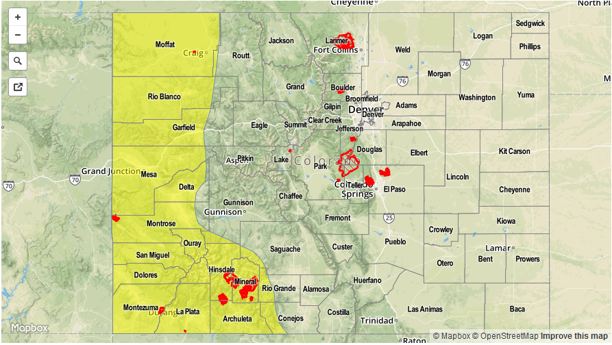

Zone-Specific Forecasts
Urban Corridor, Palmer Ridge, Northeast Plains, Raton Ridge and Southeast Plains:
Isolated-to-scattered showers/storms are expected, with the best coverage along/near the mountains and the preferred terrain of the Palmer Ridge and Raton Ridge. Primary threats from stronger thunderstorms will be strong, gusty winds (up to 45 mph), small hail, and lightning. Maximum rain rates will be as follows:
Urban Corridor and Raton Ridge: 0.4-0.7 inches/hour
Southeast Plains: 0.6-1.0 inches/hour
Palmer Ridge: 0.3-0.6 inches/hour
Northeast Plains: 0.6-0.9 inches/hour
Timing: 1 PM – 11 PM
Front Range, Southeast Mountains, Northern Mountains, Northwest Slope, San Juan Mountains, Southwest Slope, San Luis Valley, Central Mountains, and Grand Valley:
Numerous showers/thunderstorms are expected throughout today and tonight, with the best coverage over the San Juan Mountains, Southwest Slope, Grand Valley, and Northwest Slope. Isolated severe storms will mix in along/near the Utah border, with the main threats being damaging wind gusts and lightning. In addition to the showers/thunderstorms, tightening pressure gradients will result in strong/gusty winds throughout the day, with many High Wind Warnings issued. Please visit your local NWS office website for more details. As for maximum rain rates, they are as follows:
Northwest Slope, Grand Valley, Southwest Slope, and San Juan Mountains: 0.6-0.8 inches/hour
Front Range, Southeast Mountains, San Luis Valley, and Northern Mountains: 0.4-0.6 inches/hour
Central Mountains: 0.3-0.5 inches/hour
While rain rates will be marginal for flash flooding, multiple rounds of rainfall will be the main cause for concern, especially in steeper terrain areas where mudflows/landslides/etc. are common, relatively speaking.
Timing: 11 AM – 11 AM