Issue Date: Wednesday, September 14th, 2016
Issue Time: 10:30AM MDT
— LOW flood threat for Northeast Plains, Southeast Plains, Palmer Ridge and Raton Ridge
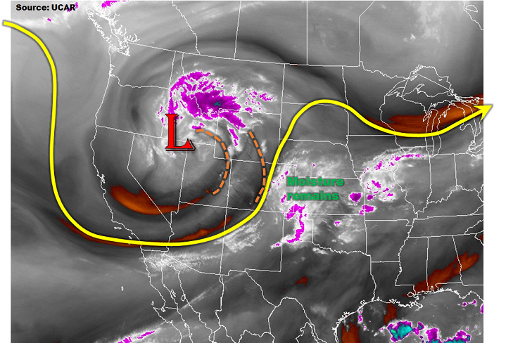
The cut-off trough of low-pressure is centered over the northern Great Basin this morning, as can be seen in the water vapor image below. The disturbance is being supported by several jet streaks with winds approaching 100 mph aloft. Moisture is marginal overall with precipitable water (PW) values in the 0.6 to 0.8 inch range, except up to 1.0 inch along the Kansas border. Expect PWs to stay steady overall, though additional moistening is possible in the far east regions. Much like yesterday, an expansive low and mid-level cloud deck is seen this morning across the eastern third of CO. This will inhibit solar insolation and keep temperatures suppressed into the 60s for areas near the Kansas border. Low-level flow this morning is from the S/SSE and this is expected to intensify through the day. Such a flow will result in upslope flow on the southern faces of the Cheyenne and Palmer Ridges, which is where today’s heavy rainfall threat will be. Although isolated heavy rainfall will be possible, it will be mitigated by relatively fast storm motion, shallow moist layer and limited instability. Nonetheless, a Low flood threat is warranted for parts of eastern Colorado as even short-term heavy rainfall could lead to isolated flash flooding, and field flooding. Elsewhere, light to moderate rainfall amounts of up to 0.5 inches (through tomorrow morning) will be the norm.
Today’s Flood Threat Map
For more information on today’s flood threat, see the map below (hover over threat areas for more details). For Zone-Specific forecasts, scroll below the map.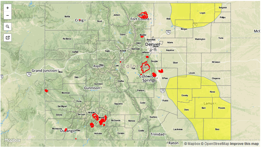

Zone-Specific Forecasts:
Southeast Plains, Northeast Plains, Palmer Ridge, Raton Ridge:
Partly to mostly cloudy early then scattered thunderstorms and showers developing by early afternoon. Highest coverage will be in two areas: one in the Southeast Plains, the other in the Northeast Plains. Maximum rainfall rates are as follows:
- Northeast Plains: Up to 0.9 inches / 30min, 1.7 inches / hour
- Southeast Plains: Up to 1.1 inches / 30 min, 1.9 inches / hour
Hail up to 1.5 inches could accompany the strongest storms. A Low flood threat has been issued for parts of the region.
Primetime: 2PM to 8PM, except 10PM far southeast
Front Range, Urban Corridor, Southeast Mountains:
Partly cloudy early then isolated to scattered showers and perhaps a weak thunderstorm developing by early afternoon. Max 1-hr rain rates up to 0.6 inches. Flooding is not expected today. Gusty winds up to 45 mph and hail up to 0.75 inches could accompany the strongest storms.
Primetime: 2PM to 8PM
San Juan Mountains, Southwest Slope, Grand Valley, Central Mountains, San Luis Valley, Northwest Slope, Northern Mountains:
Partly cloudy with isolated showers increasing in coverage with weak thunderstorms also possible. Max 1-hr rain rates up to 0.6 inches. Hail up to 0.5 inches and gusty winds up to 60mph could accompany the strongest storms. Flooding is not expected today.
Primetime: 11AM to 7PM