Issue Date: 5/12/2015
Issue Time: 10:05 AM
A MODERATE FLOOD THREAT HAS BEEN ISSUED FOR THE CACHE LA POUDRE/SOUTH PLATTE RIVER FROM GREELEY THROUGH JULESBURG, AND FOR THE ARKANSAS RIVER FROM PUEBLO THROUGH LA JUNTA.
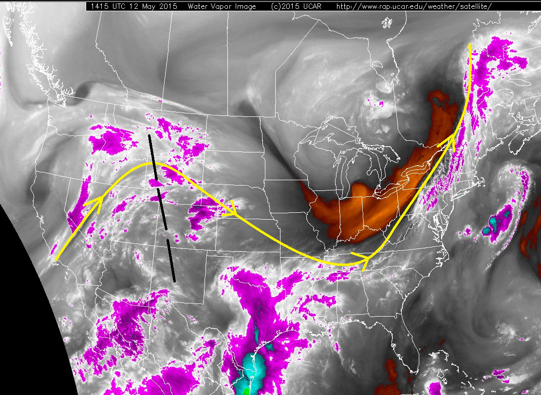
Showers and thunderstorms will make a return to parts of Colorado as the upper-level ridge shifts eastward. Take a look at the black-dashed line on the water vapor imagery below (represents the ridge axis). To the right of the axis, northwest flow aloft, and to the left, southwest flow. Southwest flow aloft means a bit more moisture will be present in the mid- and upper-levels, providing some fuel for isolated-to-scattered showers and thunderstorms this afternoon and evening, mainly over the higher terrain (a couple of showers continuing overnight). The best chance of scattered storms will be over the San Juan Mountains and Central Mountains, with storms being more isolated across the Northern Mountains, Northwest Slope, Southwest Slope, Grand Valley, San Luis Valley, Front Range, and Southeast Mountains. Additionally, a few isolated storms will work over the Urban Corridor, Palmer Ridge, Northeast Plains, and Southeast Plains during the afternoon and evening hours.
Moisture will not be deep enough to cause flooding concerns from thunderstorm rainfall today with precipitable water values near, or below, 0.5 inches. Additionally, most of the moisture is contained to the mid- and upper-levels of the atmosphere, while the low-levels remain fairly dry. This all equals a day where the strongest thunderstorms will produce more gusty winds than rain.
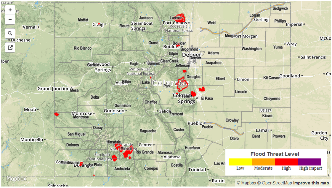
Today’s Flood Threat Map
For more information on today’s flood threat, see the map below (hover over threat areas for more details). For Zone-Specific forecasts, jump below the map.
Zone-Specific Forecasts
Urban Corridor, Palmer Ridge, Northeast Plains, and Southeast Plains:
Mostly cloudy for the Urban Corridor and Palmer Ridge, and mostly sunny for the Northeast and Southeast Plains. A few isolated storms will move off of the higher terrain this afternoon, moving in a southwest-to-northeast direction. Max rain rates will be in the 0.4-0.8 inches/hour range, but drier air in the low-levels will work against that, making the actual rain rates at the surface more likely 0.3-0.5 inches/hour.
Timing of storms: 2 PM – 10 PM, with one or two showers continuing until midnight.
Central Mountains and San Juan Mountains:
Scattered showers and thunderstorms expected today, beginning between 11 AM and Noon, and continuing until 10 PM, with isolated showers continuing through the night and into tomorrow morning. Thunderstorms will result more in gusty winds than rain. Max rain rates will be in the 0.5-0.8 inch/hour range, but as is the case for the region above, drier air in the lower-levels will work against that, likely resulting in rain rates near 0.4-0.6 inches/hour.
Front Range, Northern Mountains, Northwest Slope, Southwest Slope, Southeast Mountains and Raton Ridge:
Isolated showers and thunderstorms will begin around Noon, and continue through the afternoon and evening hours. Storms will diminish from north to south this evening, with southern mountain locations experiencing isolated showers into tomorrow morning. Rain rates will be in the 0.25-0.45 inches/hour range.
Grand Valley and San Luis Valley:
Isolated showers and thunderstorms will drift off of the surrounding higher terrain and over the valleys this afternoon and evening, producing mainly gusty winds and light rain.
Timing: Noon – Midnight for the Grand Valley, Noon – 6 AM for the San Luis Valley