Issue Date: Thursday, August 25th, 2016
Issue Time: 10:20AM MDT
— LOW flood threat for Palmer Ridge, parts of Southeast Plains, Raton Ridge, Urban Corridor and Front Range
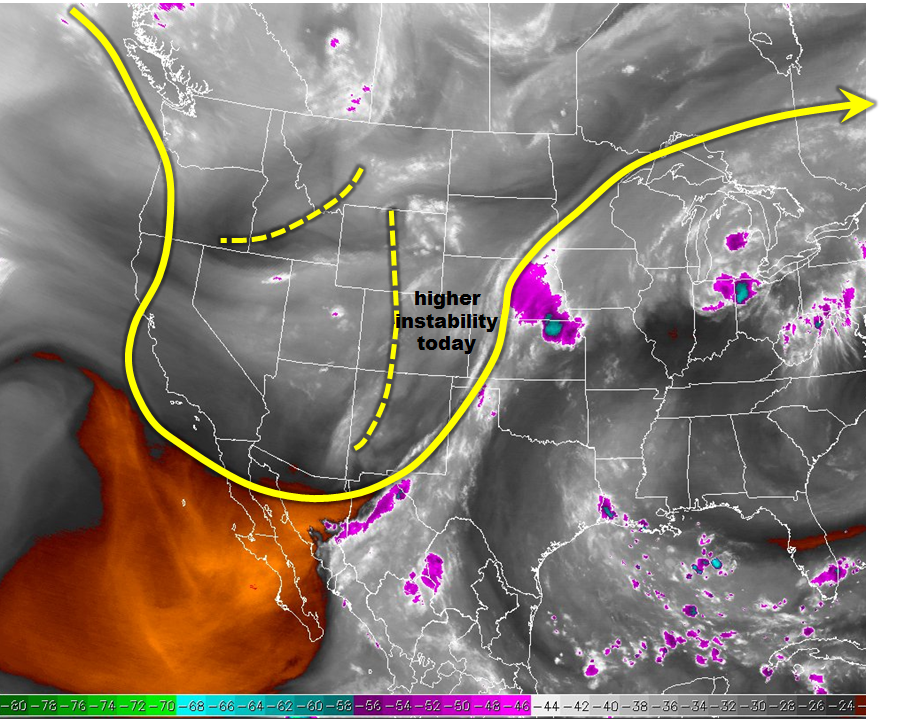
The trough that has been affecting Colorado’s weather pattern for the better part of 3 days continues to stay put while small disturbances rotate through it on a daily basis. The water vapor image, below, shows another such disturbance located across western Colorado. As this feature moves east, it will provide favorable dynamics in the form of cool temperatures aloft and mid-level upward motion. With clear skies nearly statewide this morning, temperatures will be able to warm into the 70s and 80s over lower elevation locations. This will be enough to cause scattered to widespread thunderstorm activity mainly over the Palmer Ridge and surrounding areas. A Low flood threat has been posted here. One negative factor today is the relatively dry air in eastern Colorado that will try to advect westward as upslope flow develops by early afternoon. This will likely limit heavy rainfall to the foothills and immediate areas. Due to the cold air aloft, hail up to 0.75 inches will be possible with the strongest storms.
Today’s Flood Threat Map
For more information on today’s flood threat, see the map below (hover over threat areas for more details). For Zone-Specific forecasts, scroll below the map.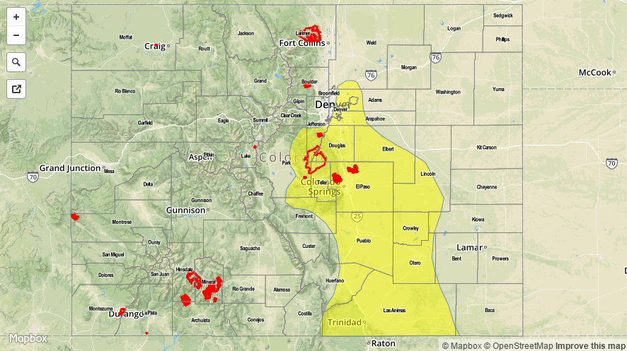

Zone-Specific Forecasts:
Front Range, Urban Corridor, Palmer Ridge, Northeast Plains, Raton Ridge, Southeast Plains, Southeast Mountains:
Sunny early and much warmer with scattered thunderstorms developing by early afternoon. Coverage will be highest along the Palmer Ridge and surrounding areas. Max 30-minute rainfall up to 0.9 inches is possible, with max 1-hr rates up to 1.4 inches. Isolated flash flooding, debris slides and mud flows are possible, especially due to the wet soils from yesterday’s steady rain. Hail up to 0.75 inches is possible under the strongest cells. A Low flood threat has been issued.
Primetime: 1PM to 9PM
San Juan Mountains, San Luis Valley, Northwest Slope, Northern Mountains, Central Mountains, Grand Valley, Southwest Slope:
Mostly sunny this morning then scattered to showers and thunderstorms developing by early afternoon. Max 1-hr rain rates up to 0.5 inches possible with max 24-hour rainfall up to 0.9 inches. Hail up to 0.5 inches could accompany the strongest cells. Flooding is not expected today.
Primetime: 12PM to 7PM