Issue Date: Tuesday, August 23rd, 2016
Issue Time: 10:00AM MDT
— LOW flood threat for San Juans, Grand Valley, Central Mountains, Southwest Slope and Southeast Mountains
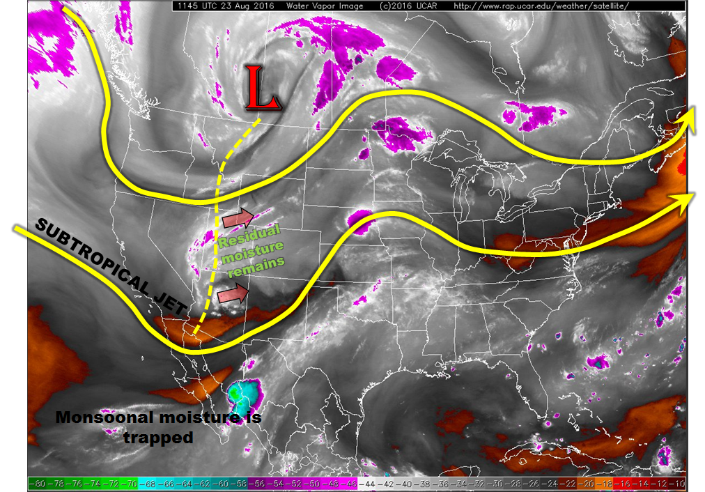
Today’s weather map, shown overlaid on the water vapor image below, has not changed much since yesterday. The broad trough is now centered over southern Alberta and has only slowly progressed eastward. However, a more noticeable southern end circulation is seen today over northern Arizona. This will be the most notable feature for Colorado’s weather today. A rather broad cloud deck is noted this morning over the southwest part of the state, stretching back into UT and AZ. This cloud deck is an indicator of the synoptic scale upward motion being caused by the disturbance. As it slowly treks northeast into northern NM and CO, solar heating will cause widespread showers and thunderstorms across a similar region as yesterday. However, despite fairly high moisture content with Grand Junction’s morning precipitable water reading around 0.9 inches, the broad thick cloud deck will likely limit instability more so than yesterday. Although isolated heavy rainfall is expected, today’s flood threat is kept at a Low status due to the expected short duration of such rainfall. Instead, light to moderate rainfall is more likely for most of the afternoon and evening hours for most of the western slope and into the northern parts of the Southeast Mountains. East of the Continental Divide, dry air from Wyoming will once again limit rainfall chances, although a shower or weak storm will likely prevail closer to the foothills and mountains.
Today’s Flood Threat Map
For more information on today’s flood threat, see the map below (hover over threat areas for more details). For Zone-Specific forecasts, scroll below the map.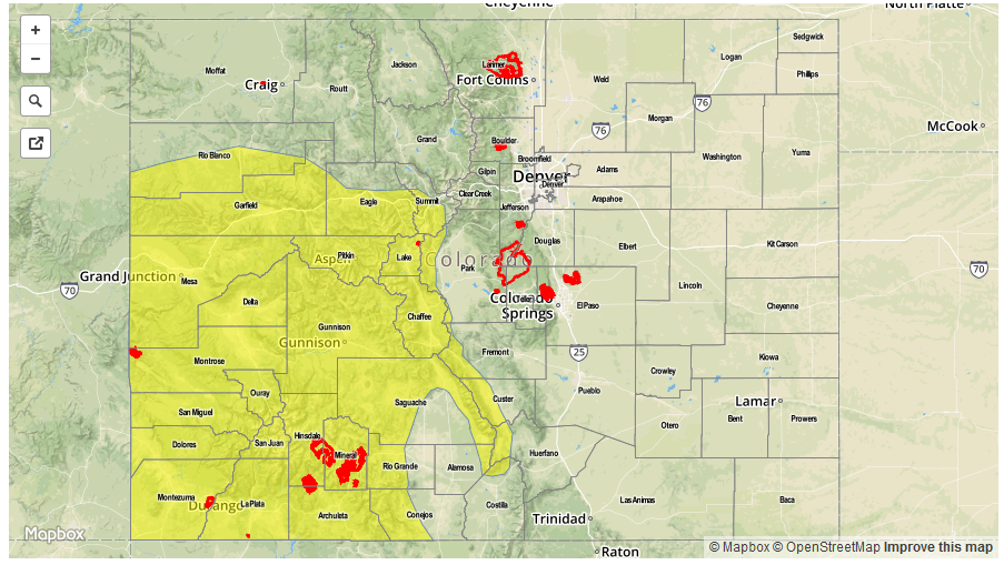

Zone-Specific Forecasts:
San Juan Mountains, Southwest Slope, Grand Valley, Central Mountains, Southeast Mountains, San Luis Valley:
Partly cloudy early with widespread showers and thunderstorms quickly developing by early afternoon. Max 30-min rain rates up to 0.6 inches, 1-hour rain rates up to 1.0 inch and 6-hour rates up to 2.2 inches are possible. A Low flood threat has been posted for parts of the region. Showers and a weak storm will continue into the overnight hours. Hail up to 0.5 inches may accompany the stronger afternoon and evening cells.
Primetime: 12PM to 10PM, but rainfall continuing overnight
Northwest Slope, Northern Mountains:
Partly cloudy early then scattered showers and weak thunderstorms developing by early afternoon. Maximum 1-hour rain rates up to 0.5 inches are possible, with maximum 24-hour rainfall up to 0.8 inches. Flooding is not expected today. Scattered showers may continue into the overnight hours.
Primetime: 1PM to 7:30PM
Front Range, Urban Corridor, Palmer Ridge, Northeast Plains, Raton Ridge, Southeast Plains:
Mostly sunny early and continued warm. Isolated to scattered showers and thunderstorms are possible across higher terrain and foothills. Max 1-hour rain rates up to 0.5 inches are possible, except up to 0.8 inches in the Southeast Plains. Flooding is not expected. Scattered showers and a weak storm will likely continue into the overnight hours closer to the mountains and foothills as upslope flow develops from the incoming disturbance.
Primetime: 1PM to 9PM