Issue Date: Monday, August 22nd, 2016
Issue Time: 10:24AM MDT
— MODERATE flood threat for San Juans, Grand Valley and Central Mountains
— LOW flood threat for Southwest Slope
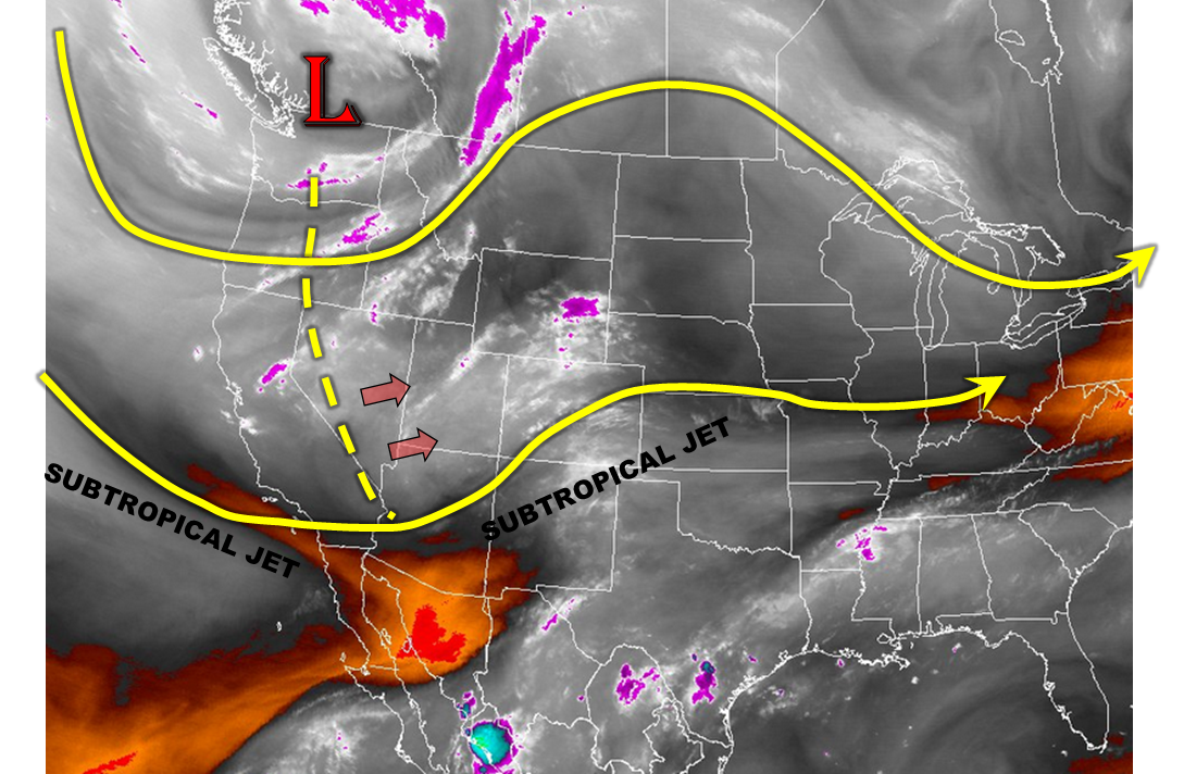
Changes are on seen on this morning’s weather map, overlaid on the water vapor image below. A large-scale disturbance, with its center located over British Columbia, is carrying a long trough that extends southward through the Mexico border. Of importance for Colorado is the southern fringe of this activity, which is being maintained by a strong subtropical jet stream. As the disturbance moves east today, it will promote widespread lift and thus, shower and thunderstorm activity west of the Divide. Some of this can already been seen on morning radar and visible satellite loops across UT and western CO. Precipitable water values have jumped from below 0.4 inches to over 0.8 inches at Grand Junction and Durango. North of the San Juans, most of this moisture is found above the boundary layer so it will take several hours before moisture is transported to the surface through rainfall and moisture transport from the south. However, dew point temperatures at or over 50F are found just south of the NM/CO border so there is a nearby source of higher moisture. Despite marginal instability today, convective temperatures will be reached with help from dynamical forcing. Numerical weather prediction guidance suggests moderate to high probabilities of exceeding 1 inch of rainfall across the southwest, and there is no reason to doubt this given the overall pattern. In all, a Moderate flood threat is in place for parts of the San Juans and Central Mountains, with a Low flood threat surrounding those areas. The main impact will be from heavy rainfall at durations of 30-minutes to 3-hours.
Today’s Flood Threat Map
For more information on today’s flood threat, see the map below (hover over threat areas for more details). For Zone-Specific forecasts, scroll below the map.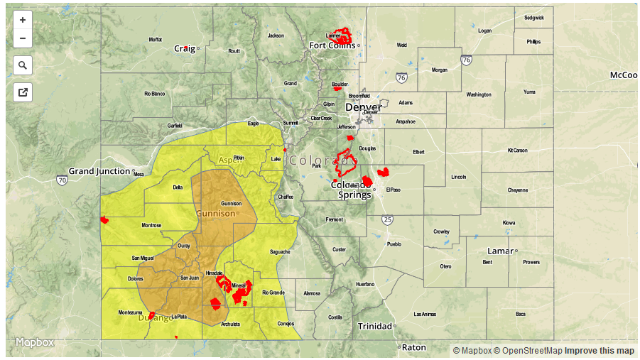

Zone-Specific Forecasts:
San Juan Mountains, Southwest Slope, Grand Valley, Central Mountains:
Mostly cloudy early with scattered showers giving way to widespread showers thunderstorms developing by early afternoon. Max 30-min rain rates up to 0.7 inches,1-hour rain rates up to 1.1 inch and 3-hour rates up to 2.4 inches are possible. A Moderate flood threat has been posted for parts of the regions with a Low flood threat surrounding that region. Hail up to 0.5 inches may accompany the stronger cells.
Primetime: 1PM to 9PM
Northwest Slope, Northern Mountains, San Luis Valley:
Partly cloudy early then scattered showers and weak thunderstorms developing by early afternoon. Maximum 1-hour rain rates up to 0.6 inches are possible, with maximum 24-hour rainfall up to 1 inch. Flooding is not expected today.
Primetime: 1PM to 7:30PM
Southeast Plains:
Sunny early, then partly cloudy with isolated to scattered thunderstorms possible. Max 1-hour rainfall up to 1.4 inches is possible. However, flooding is not expected today. Hail up to 1.25 inch may accompany the strongest storms.
Primetime: 3PM to 9PM
Front Range, Urban Corridor, Palmer Ridge, Northeast Plains, Southeast Mountains, Raton Ridge:
Mostly sunny early and continued warm. Isolated to scattered showers and thunderstorms are possible across higher terrain and foothills. Max 1-hour rain rates up to 0.5 inches are possible. However, flooding is not expected.