Issue Date: Sunday, August 21st, 2016
Issue Time: 10:00AM MDT
— LOW flood threat for San Juan Mountains, Southeast Mountains, Raton Ridge and San Luis Valley
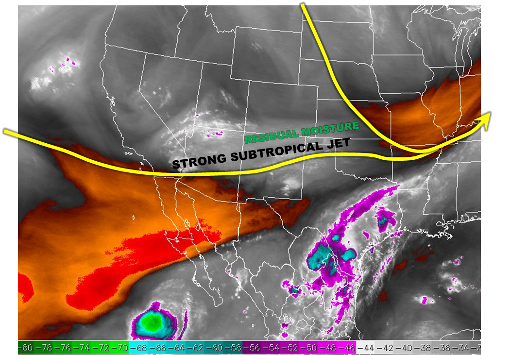
Most of Colorado will turn much warmer, but stay dry today. Just like yesterday, the one exception to this will be far southern areas of the state. The water vapor image, below, shows that a strong subtropical jet is seen this morning stretching across the southern parts of CA, AZ and into central New Mexico. This jet is very high in the atmosphere, above 30,000 feet. As we move through the day, the jet will retain strength and slowly expand northward to impact the southern tier of our state. The main impact from the jet will be to allow for an efficient “venting” of thunderstorm activity. Adequate residual moisture in place for southern areas. Surface dew point temperatures in the upper-40s to mid-50s F and precipitable water will hold in the 0.7 – 0.9 range. Thus, with instability not an issue today, we expect scattered thunderstorm activity with heavy rainfall potential to develop across favored parts of the Sangre de Cristos, Wet Mountains and San Juans during the afternoon and early evening hours. A Low flood threat is in place for these areas.
Today’s Flood Threat Map
For more information on today’s flood threat, see the map below (hover over threat areas for more details). For Zone-Specific forecasts, scroll below the map.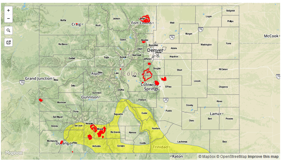

Zone-Specific Forecasts:
Southeast Mountains, Raton Ridge, Southeast Plains, San Juan Mountains, San Luis Valley:
Sunny early then becoming partly cloudy with scattered thunderstorms developing shortly after noon. Most action today will be limited to the higher terrain and foothills. Max 30-min rain rates up to 0.7 inches and 1-hour rain rates up to 1.1 inch are possible. A Low flood threat has been posted for parts of the area, including the southern part of the San Luis Valley. Hail up to 0.75 inches and gusty winds up to 60 mph may accompany the stronger cells.
Primetime: 12PM to 8:30M
Front Range, Urban Corridor, Palmer Ridge, Northeast Plains:
Partly to mostly sunny and much warmer today. Expect fair weather cumulus clouds developing by late morning. Isolated showers and weak thunderstorms are possible closer to the higher terrain during the afternoon hours. Max 1-hour rain rates up to 0.4 inches are possible. Flooding is not expected today.
Southwest Slope, Grand Valley, Central Mountains, Northwest Slope, Northern Mountains:
Mostly sunny early then partly cloudy and much. An isolated shower or storm cannot be ruled out for far southern areas. Max 1-hour rain rates up to 0.3 inches. Flooding is not expected today.