Issue Date: Friday, August 19th, 2016
Issue Time: 10:25AM MDT
— MODERATE flood threat for Palmer Ridge and Southeast Plains
— LOW flood threat for Northeast Plains, Urban Corridor, Front Range, Southeast Mountains, Raton Ridge and San Juans
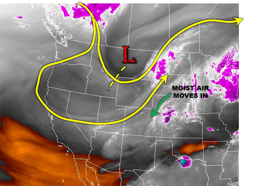
An active weather map is seen across the western US this morning, as shown in the water vapor image below. There are two disturbances located north/west of Colorado today. The main feature will be the trough, and associated fall-like cool front (frost advisories have been posted for higher elevations of south-central WY), currently positioned over Montana that is racing south-southeastward and will enter Colorado during or slightly after peak heating. Morning soundings look tropical-like east of the Divide with precipitable water (PW) values hovering in the 0.8 – 0.9 inch range. A feed of moist air will be continuous over eastern Colorado today ushering in low-level dew points up to 60F, which will raise PWs into the 0.9 – 1.1 inch range. One to two rounds of storms will be likely east of the Divide. Maximum rainfall rates will be dictated by the amount of heating that can prep the atmosphere before rainfall starts. Currently the cloud deck is most expansive over far northern/eastern parts of the state. Thus, storms will likely build off the higher terrain first and then race southeastward, with a potential to spread eastward towards the Kansas border as the AM cloud deck dissipates. Despite the fast storm motion, strong convergence implies that short-term rainfall rates in the 5-30 minute range will be capable of producing a flash flood threat. A given location could see multiple rounds of storms, which will also increase the overall flood threat. A Low flood threat has been posted for parts of eastern Colorado with a Moderate threat for areas where instability is expected to be highest. Severe weather (hail up to 1.25 inches and winds up to 70mph) will be possible with the strongest storms.
Today’s Flood Threat Map
For more information on today’s flood threat, see the map below (hover over threat areas for more details). For Zone-Specific forecasts, scroll below the map.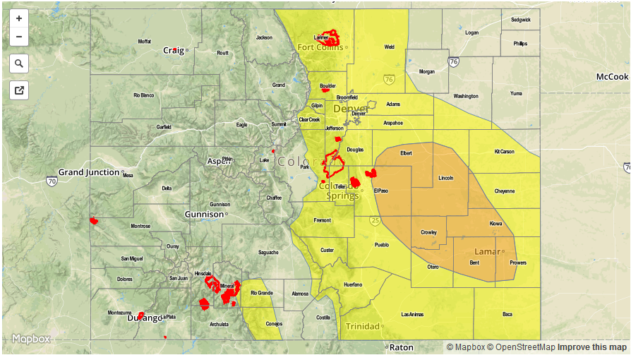

Zone-Specific Forecasts:
Front Range, Urban Corridor, Palmer Ridge, Southeast Mountains, Raton Ridge, Southeast Plains, Northeast Plains:
Partly sunny early, then scattered to widespread showers and thunderstorms developing by early afternoon. First areas to see action will be higher terrain of Front Range, then action will spread southeast and possibly east. Max 30-minute rain rates up to 1.4 inches will be possible, with max 3-hour rain rates up to 2.9 inches over parts of the Palmer Ridge. Hail up to 1.25 inches and gusty winds up to 70mph will be possible with the strongest storms. Much cooler behind the storms will scattered showers possible through the night. A Moderate flood threat has been posted for parts of the area, with a Low flood threat surrounding that area.
Primetime: 12PM to 8PM (for Moderate threat) but 11PM for Low threat far southeast
San Juan Mountains, Southwest Slope, Grand Valley, Central Mountains, San Luis Valley:
Sunny early with isolated to scattered showers and thunderstorms developing by 1pm. Max 1-hour rainfall up to 0.8 inches could cause isolated flash flooding, debris slides and mud flows near the New Mexico border. A Low flood threat has been posted for a small part of the region. Flooding is not expected elsewhere.
Primetime: 12PM to 7PM
Northwest Slope, Northern Mountains:
Sunny early then partly cloudy with isolated showers and a weak storm possible during the afternoon. Max 1-hour rain rates up to 0.4 inches are possible, but flooding is not expected.