Issue Date: 8/18/2016
Issue Time: 10:12 AM
A LOW FLOOD THREAT IS FORECAST FOR PORTIONS OF THE NORTHERN MOUNTAINS, FRONT RANGE, CENTRAL MOUNTAINS, SOUTHWEST SLOPE, SAN JUAN MOUNTAINS, SOUTHEAST MOUNTAINS, SOUTHEAST PLAINS, URBAN CORRIDOR, PALMER RIDGE, AND NORTHEAST PLAINS.
The weak ridge that has been overtop the state will be pushed aside today as the upper-trough (yellow line) continues to deepen and begins its sweep to the east. Embedded within the mid-/upper-level flow is a weak wave (purple line) that will rotate across Colorado today, combining with daytime heating and orographic effects to kick off another period of unsettled weather. The High Country and Western Slope will be favored for the greatest coverage of showers/storms, while a few more are expected across the lower elevations of eastern Colorado as compared to yesterday. IPW values will tick upward again this afternoon, providing sufficient moisture for periods of moderate rainfall. Slow-moving storms are the main concern for any flooding issues, especially in the higher terrain and across burn scars.
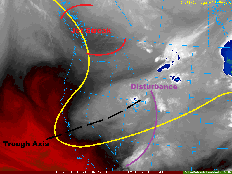
A couple strong-to-severe storms will be possible across the northern fringes of the state, mainly the far northern extents of the Northeast Plains and Urban Corridor. A cool front will be knocking on Colorado’s door this evening, providing a focus for storm development across Wyoming. A couple of these storms may progress far enough southward to sneak into Colorado, with the main threats being large hail (up to 1.5 inches in diameter) and strong winds (gusts up to 50-60 mph). Otherwise, this cool front will continue to push into the state overnight, increasing surface moisture and upslope flow behind it, and keeping a few showers/weak thunderstorms going into the morning hours. The cool front will set the stage for heavy rain tomorrow.
Today’s Flood Threat Map
For more information on today’s flood threat, see the map below (hover over threat areas for more details). For Zone-Specific forecasts, jump below the map.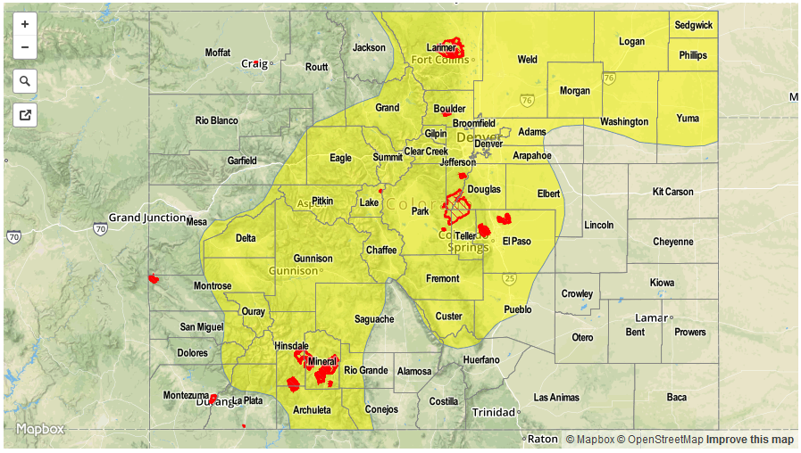

Zone-Specific Forecasts
Urban Corridor, Northeast Plains, Palmer Ridge, Southeast Plains and Raton Ridge:
Isolated-to-scattered showers/storms are expected, with the best coverage along/near the mountains, as well as far northern extents of the Northeast Plains and Urban Corridor (near the cool front). Most showers/storms will be garden variety, producing light-to-moderate rainfall, but a stronger storm or two will be capable of producing heavy rain, hail, and strong winds. Urban areas with poor drainage will be the main concern for flooding issues today. Maximum rain rates are as follows:
Urban Corridor and Palmer Ridge: 1.0-1.4 inches/hour
Northeast Plains: 1.5-2.2 inches/hour
Southeast Plains and Raton Ridge: 0.5-0.8 inches/hour
Timing: 1 PM – 11 PM, with a couple showers/weak storms continuing into the morning hours (mainly over the Northeast Plains and Urban Corridor)
Front Range, Southeast Mountains, Northern Mountains, Northwest Slope, San Juan Mountains, Southwest Slope, San Luis Valley, Central Mountains, and Grand Valley:
Scattered showers/thunderstorms are expected, favoring the higher terrain, with more widely scattered coverage over the lower valleys. Slow-moving storms will be the main concern behind the low flood threat today, as well as increased moisture promoting more efficient rainfall. Maximum rain rates are as follows:
Front Range, Northern Mountains, Grand Valley, and Southeast Mountains: 0.9-1.3 inches/hour
Central Mountains, Southwest Slope, and San Juan Mountains: 0.8-1.2 inches/hour
San Luis Valley: 0.4-0.7 inches/hour
Northwest Slope: 0.5-0.8 inches/hour
Timing: 11 AM – 10 PM, with a few isolated showers continuing until around midnight