Issue Date: 8/17/2016
Issue Time: 10:03 AM
A LOW FLOOD THREAT IS FORECAST FOR PORTIONS OF THE SAN JUAN MOUNTAINS, SOUTHWEST SLOPE, CENTRAL MOUNTAINS, SOUTHEAST MOUNTAINS, SOUTHEAST PLAINS, URBAN CORRIDOR, RATON RIDGE, AND FRONT RANGE.
Mid-level moisture continues its presence across the state today, fueling another period of isolated-to-scattered showers/thunderstorms. More so than yesterday, showers and storms will favor the High Country, with scattered coverage expected over the higher terrain, and isolated-to-widely scattered coverage over the valleys and adjacent lower elevations. A couple isolated storms will also be possible further east this evening, favoring areas near the Palmer Ridge, Cheyenne Ridge, and Raton Ridge.
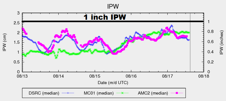
Even though moisture values are fairly average for this time of year, a slight bump this afternoon will push IPW towards 0.8-0.9 inches at the 3 normal reporting stations (Schriever AFB, Boulder, and Grand Junction). This will provide enough moisture for a few bouts with locally moderate-to-heavy rain, mainly in the areas outlined by the low flood threat. Slow storm motions are the main concern driving this threat, as storm organization will not be great and moisture is so-so. The main threats in the low-end, low flood threat will be street/field ponding/minor flooding, as well as burn scar runoff issues. The Hayden Pass Fire burn is especially vulnerable to heavy rain, so that will need to be monitored closely. For more details on rain rates and timing, please see the zone-specific forecast discussions below.
Today’s Flood Threat Map
For more information on today’s flood threat, see the map below (hover over threat areas for more details). For Zone-Specific forecasts, jump below the map.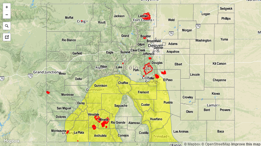

Zone-Specific Forecasts
Urban Corridor, Northeast Plains, Palmer Ridge, Southeast Plains and Raton Ridge:
Isolated-to-widely scattered showers/thunderstorms expected, mainly along/near the higher terrain. Most activity will be garden variety, resulting in gusty winds, lightning, and periods of light-to-moderate rainfall. One or two stronger storms are possible, mainly across southern extents of the Urban Corridor and western portions of the Southeast Plains. Minor street/field ponding/flooding will be possible underneath stronger storms, thus the inclusion in the low-end, low flood threat. Maximum rain rates are as follows:
Urban Corridor, Southeast Plains, and Raton Ridge: 0.8-1.2 inches/hour
Palmer Ridge and Northeast Plains: 0.5-0.7 inches/hour
Timing: Noon – 10 PM
Front Range, Southeast Mountains, Northern Mountains, Northwest Slope, San Juan Mountains, Southwest Slope, San Luis Valley, Central Mountains, and Grand Valley:
Scattered showers/storms are expected today, favoring the higher terrain, with more isolated-to-widely scattered coverage across the valleys. The best low-level moisture exists across southern Colorado, which will lead to slightly more efficient rainfall. For this reason, plus the concern for slow storm motions, the issuance of the low-end, low flood threat is warranted. Maximum rain rates are as follows:
Northwest Slope, Northern Mountains, San Luis Valley, and Grand Valley: 0.4-0.7 inches/hour
Southwest Slope and Central Mountains: 0.8-1.2 inches/hour
San Juan Mountains: 1.0-1.4 inches/hour
Front Range and Southeast Mountains: 0.6-1.1 inches/hour
Timing: 11 AM – 11 PM, with a few isolated showers continuing into the early morning hours