Issue Date: May 10th, 2015
Issue Time: 10:15AM
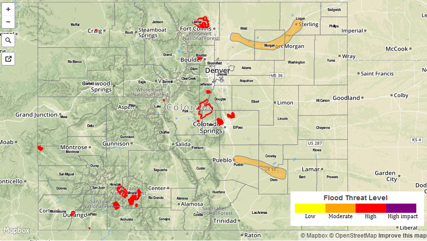
— MODERATE flood threat for South Platte River from Greeley through Sterling
— MODERATE flood threat for Arkansas River from Pueblo through La Junta
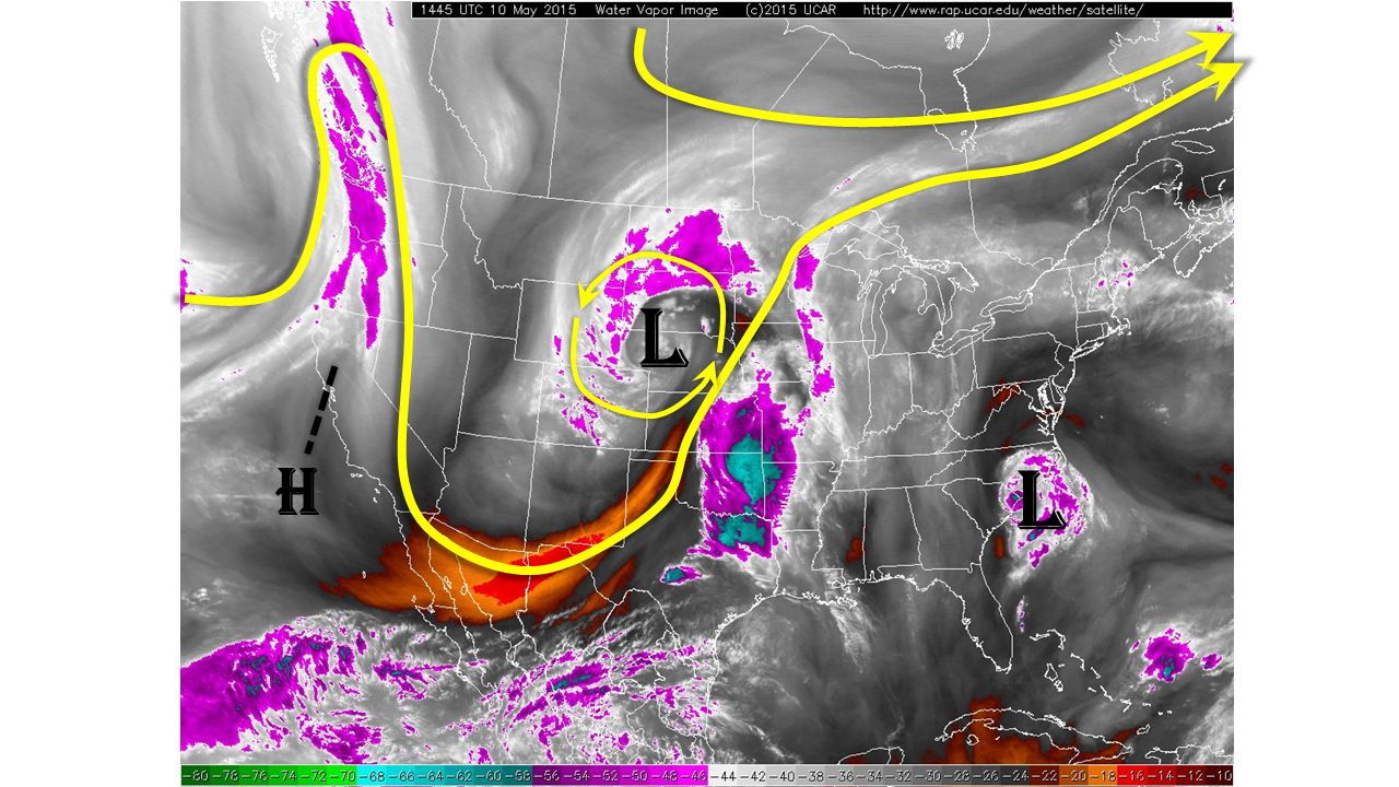
The departing of yesterday’s impressive late spring snowstorm has left partly to mostly cloudy skies across most of Colorado. Snow showers are still ongoing across mainly the higher terrain. Today will finally bring necessary, but intermittent sunshine along with some drying especially for lower elevations. The water vapor imagery below shows the departing storm currently positioned over western Nebraska and South Dakota. As it moves farther away from Colorado, all precipitation should slowly come to an end this afternoon and evening. Sunshine will try to break through the clouds but may have a difficult time with so much low-level moisture remaining in the saturated ground. Temperatures will be unseasonably cold for this time of year with mountain locations staying in the 20s, while lower elevations warm to the 30s and 40s. The only exception is the southeast corner of the state where temperatures may climb to 60F.
Although there is no significant precipitation in the forecast today, Moderate flood threats have been posted for the Arkansas River from Pueblo through La Junta, and for the South Platte River from Greeley through Sterling. At this time, it appears that the additional snowmelt will add more runoff for the next 12-24 hours and most rivers should see their crest by midday tomorrow.

Please see below for area-specific flood threat and forecasts (click on “About the FTB” link above to view Colorado region names).
Zone-Specific Forecasts
Urban Corridor, Front Range, Northeast Plains, Palmer Ridge, Raton Ridge and Southeast Plains:
Scattered snow showers will slowly diminish over the late morning and afternoon hours. Sunshine will try to break through the clouds this afternoon. No significant precipitation is forecasted today, but a Moderate flood threat is in place for the South Platte River from Greeley through Sterling. Parts of this stretch of the South Platte are already in “Action” and Minor Flooding stages. The river is likely to rise a bit more throughout the day before cresting tomorrow. Please keep an eye on National Weather Service warnings for specific flood information.
Central Mountains, San Juan Mountains, Southeast Mountains and Northern Mountains:
Scattered snow showers will persist into the early afternoon hours. Additional snow accumulations of up to 10 inches may occur in isolated locations. No flood threat is expected today and cold temperatures prevent runoff. However, flooding concerns may arise as warm temperatures return in the coming days.
Southwest Slope, Northwest Slope, Grand Valley and San Luis Valley:
Partly cloudy and cool with isolated snow showers possible through early afternoon. No flooding is expected today. However, snowmelt induced flooding concerns may begin to develop as temperatures warm in the coming days.