Issue Date: Sunday, August 7th, 2016
Issue Time: 10:10AM MDT
— MODERATE flood threat for Front Range, Urban Corridor, Palmer Ridge and Northeast Plains
— LOW flood threat for Southeast Plains, San Juans, Grand Valley, Central Mountains and Southwest Slope
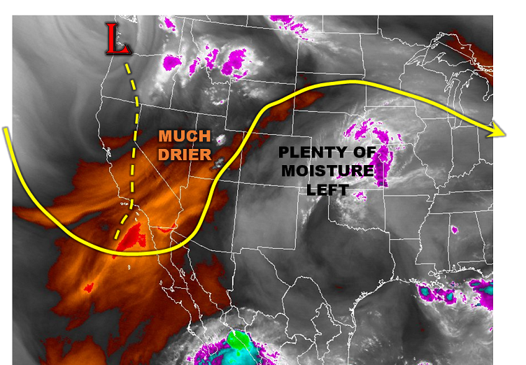
Although precipitable water (PW) values have dropped off to around or just under 1 inch for many areas, there are several factors today that will continue to support a heavy rainfall threat. First, PW measures the water vapor in total column. For consideration of heavy rainfall, it is the lower-level moisture content that is typically more important. This remains high for all areas east of the Divide as well as many parts of the western slope. For example, morning dewpoints were as high as the low 60s F. Second, aside from a very thin low-cloud deck in the northeast part of the state, most areas are under clear skies: a big difference from the past few days. This will allow maximum heating to be realized, promote a moderately strong upslope flow from the climatological heat low circulation and result in overall more instability than past few days. The one other important difference today is the approach of a large-scale trough from the west (see water vapor image below). This will provide for rainfall chances even in northwest CO, although fast steering winds will reduce the chance for heavy rainfall. Overall, we see a similar pattern as yesterday but with the possibility of heavier short-term rainfall rates due to higher instability. A Moderate flood threat is warranted for parts of eastern Colorado with a Low flood threat for parts of the southwest.
Today’s Flood Threat Map
For more information on today’s flood threat, see the map below (hover over threat areas for more details). For Zone-Specific forecasts, scroll below the map.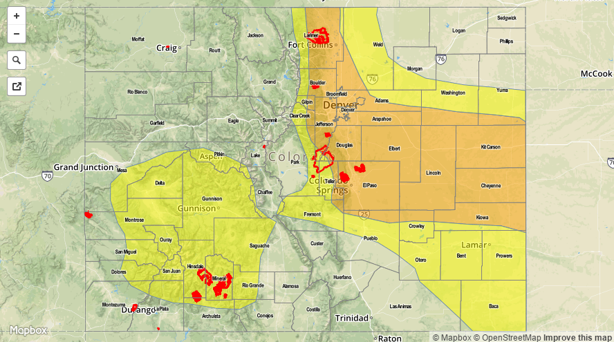

Zone-Specific Forecasts:
Front Range, Urban Corridor, Palmer Ridge, Southeast Mountains, Raton Ridge, Southeast Plains, Northeast Plains:
Sunny early, then scattered to widespread shower and thunderstorm activity developing by noon. Storms will first occur over the higher terrain and then propagate and expand in coverage farther east. Max 1-hour rain rates up to 2.5 inches will be possible, which could cause isolated flash flooding, mud flows and debris slides (in higher terrain). A moderate flood threat has been posted for parts of the region with a low flood threat surrounding that. Hail up to 0.5 inches and winds up to 55mph will be possible with the strongest cells.
Primetime: 12PM to 9PM except 11PM for eastern areas.
San Juan Mountains, Southwest Slope, Grand Valley, Central Mountains, San Luis Valley:
Sunny early with scattered showers and thunderstorms developing by noon. Max 15-minute rainfall up to 0.6 inches possible, max 1-hour up to 1.0 inch. Isolated flash flooding and debris slides are possible. Antecedent rainfall is also a factor that will cause higher runoff. A low flood threat has been posted for the San Juans and surrounding areas.
Primetime: 12PM to 8PM
Northwest Slope, Northern Mountains:
Sunny early then scattered showers and thunderstorm developing by noon. Max 1-hour rain rates up to 0.7 inches possible through the day and into the evening. An approaching disturbance will also support a chance for light to moderate rainfall (<0.4 in per hour) into the overnight hours. Flooding is not expected today.
Primetime: 12PM to 8PM