Issue Date: Saturday, August 6th, 2016
Issue Time: 10:45 AM MDT
— MODERATE flood threat for parts of Urban Corridor, Palmer Ridge and Southeast Plains
— LOW flood threat for Front Range, Southeast Mountains, San Juan Mountains, Central Mountains
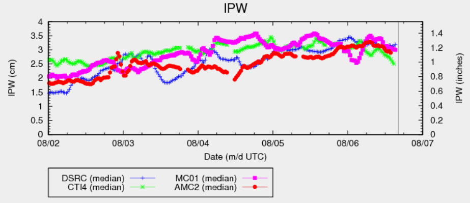
It has taken longer than expected, but low level moisture is now firmly entrenched east of the Divide. Although the precipitable water (PW) chart, below, appears to not have changed much over the past 24 hours, there has been an important redistribution of moisture so that what started as upper-level monsoonal moisture has now been transported more into the low-levels. This promotes higher instability and potential for heavy rainfall. Meanwhile, higher moisture continues to be in place west of the Divide, although the moisture spigot will slowly come to an end as substantial drying is seen over Utah and Arizona.
For today, we expect a very active day with showers and thunderstorms developing by noon over the higher terrain. West of the Divide, coverage outside of the San Juans will be more limited than past days. East of the Divide, we expect a significant increase in coverage especially over the Palmer Ridge and the Urban Corridor. A moderate flood threat is in place for parts of the region for very heavy 1-3 hour rainfall. Antecedent rainfall is also an important factor over the Southeast Plains warranting a moderate flood threat there as well. Morning low/mid-level cloud cover will likely cause weaker instability over the Northern Mountains and Northeast Plains so flooding is not expected in these regions.
Today’s Flood Threat Map
For more information on today’s flood threat, see the map below (hover over threat areas for more details). For Zone-Specific forecasts, scroll below the map.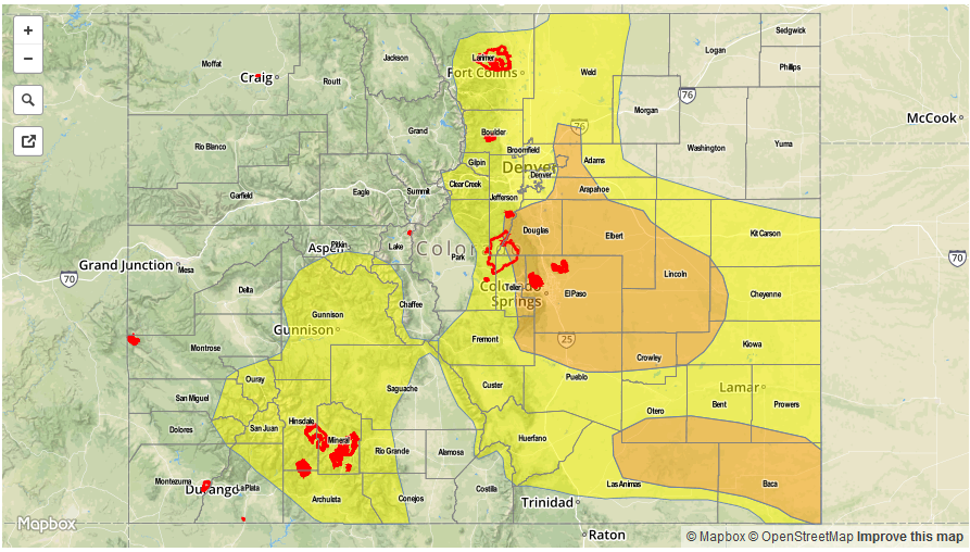

Zone-Specific Forecasts:
Front Range, Urban Corridor, Palmer Ridge, Southeast Mountains, Raton Ridge, Southeast Plains, Northeast Plains:
Partly to mostly cloudy early, then scattered to widespread shower and thunderstorm activity developing by early afternoon. Storms will first occur over the higher terrain and then propagate and expand in coverage farther east. Max 1-hour rain rates up to 2.5 inches will be possible, with max 3-hour rates up to 3.8 inches. A moderate flood threat has been posted for parts of the region with a low flood threat surrounding that. Hail up to 0.5 inches and winds up to 55mph will be possible with the strongest cells.
Primetime: 1PM to 9PM except 11PM for eastern areas.
San Juan Mountains, Southwest Slope, Grand Valley, Central Mountains:
Partly cloudy early with scattered showers and thunderstorms developing by noon. Max 15-minute rainfall up to 0.6 inches possible, max 1-hour up to 1.0 inch and max 24-hour up to 2 inches. Isolated flash flooding and debris slides are possible. Antecedent rainfall is also a factor that will cause higher runoff than with dry soils. A low flood threat has been posted for the San Juans and surrounding areas.
Primetime: 12PM to 9PM
Northwest Slope, Northern Mountains, San Luis Valley:
Mostly cloudy and with isolated to scattered showers and weak thunderstorm possible. Max 1-hour rain rates up to 0.6 inches possible. Flooding is not expected today.
Primetime: 12PM to 7PM