Issue Date: Friday, August 5th, 2016
Issue Time: 10:35AM MDT
— HIGH IMPACT flood threat for Palmer Ridge and parts of Front Range (threat persists after sunset)
— HIGH flood threat for San Juans
— MODERATE flood threat for parts of Urban Corridor, Northeast Plains, Southeast Plains, Raton Ridge and Southeast Mountains
— LOW flood threat for Grand Valley, Southwest Slope, Central Mountains and San Luis Valley
— Afternoon update possible today. Check back by 3PM.
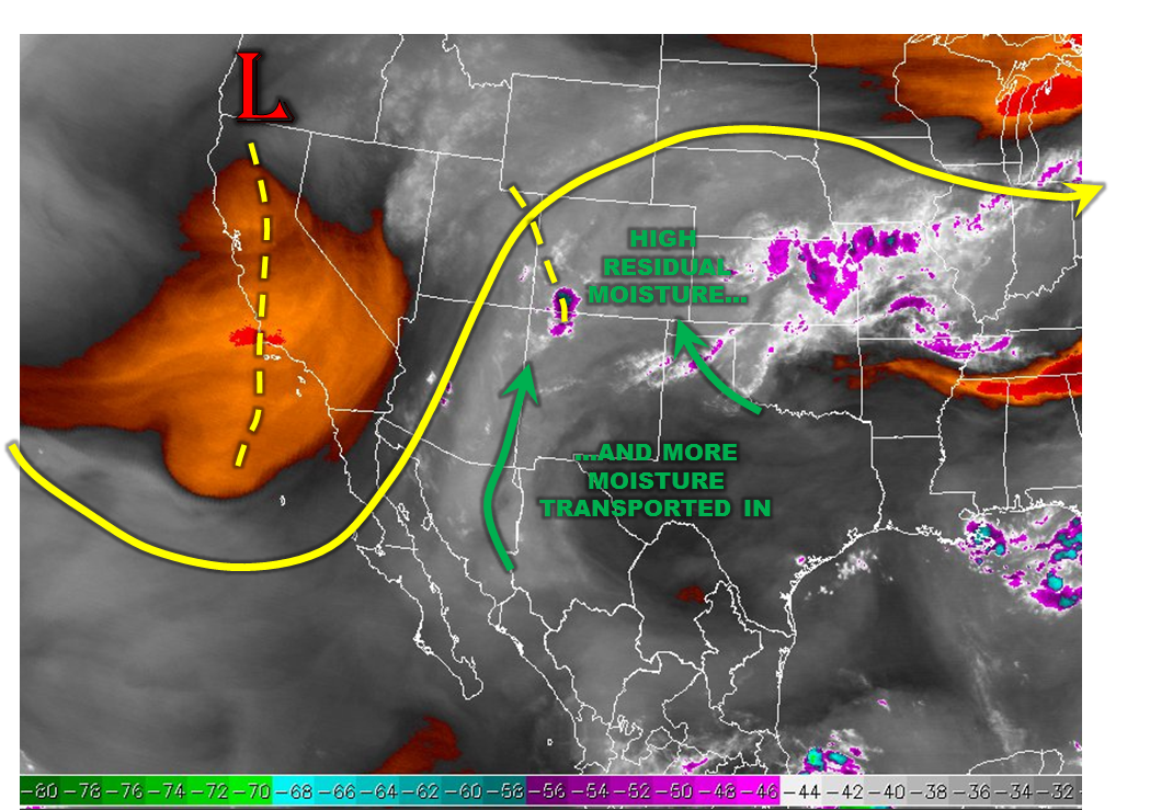
A very active weather day is expected for most of Colorado as monsoonal moisture that has largely been held west of the Divide makes it eastward. The water vapor image, below shows the factors at play. A weak ridge over the southeast US will continue to direct moisture into Colorado. Nearly the entire state is now measuring over 1 inch of precipitable water with many locations seeing values up to 1.4 inches. A cyclonic circulation is expected to strengthen over the higher terrain, which will cause an increase in low-level winds providing more moisture transport from both the southwest and southeast direction.
Ongoing showers and storms over the western slope will quickly grow in intensity in coverage. Heavy rainfall will be possible today across the region, with especially high flood threat concerns over the south faces of the San Juans where over 3 inches of rainfall has fallen over the past 3 days. It will take most of the afternoon before sufficient low-level moisture develops east of the Divide. However, at least one round of slow moving storms is likely in the late evening before activity gradually subsides. A High Impact flood threat has been posted for the Palmer Ridge due to the proximity of expected heavy rainfall to the I-25 corridor.
Today’s Flood Threat Map
For more information on today’s flood threat, see the map below (hover over threat areas for more details). For Zone-Specific forecasts, scroll below the map.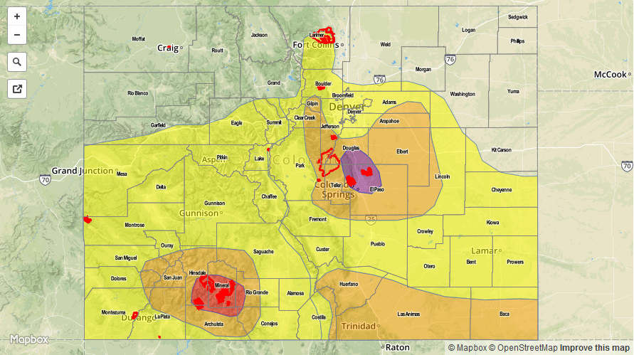

Zone-Specific Forecasts:
Front Range, Urban Corridor, Palmer Ridge:
Partly sunny early, with variable cloudiness expected through the afternoon until scattered to widespread shower and thunderstorm activity rapidly develops by mid to late afternoon. Max 1-hour rain rates up to 2.5 inches will be possible, with max 3-hour rates up to 4.0 inches. A High Impact flood threat has been posted for Colorado Springs and areas to the north (including fire scars) for flash flooding and debris/rock slides. The brunt of the activity is expected towards sunset and into the overnight hours as it takes some time to moisten the initially dry lower levels of the atmosphere. Hail up to 0.5 inches will be possible with the strongest cells.
Primetime: 3PM to 3AM
San Juan Mountains:
Mostly cloudy with scattered showers and thunderstorms this morning gaining in coverage and intensity. Max 15-minute rainfall up to 0.6 inches possible, max 1-hour up to 1.0 inch and max 24-hour up to 2.9 inches. Substantial antecedent rainfall warrants a high flood threat for the fire scars in the region with a moderate threat for surrounding areas.
Primetime: 11AM to 9PM, though threat of mud flows and debris slides will last the entire 24-hour forecast period.
Southeast Mountains, Raton Ridge, Southeast Plains, Northeast Plains:
Partly sunny early then isolated to scattered showers and thunderstorms developing by early afternoon. Max 1-hour rain rates up to 2.5 inches possible, leading to isolated flash flooding. Antecedent rainfall in the southeast parts of the region are especially vulnerable to high runoff. Hail up to 0.5 inches is possible with the strongest cells. A moderate flood threat has been posted for parts of the region, with a low threat elsewhere.
Primetime: 2PM to 11PM
Central Mountains, San Luis Valley, Grand Valley, Southwest Slope:
Mostly cloudy with scattered showers increasing in coverage and intensity by early afternoon. Max 1-hr rain rates up to 1.1 inches possible. Isolated flash flooding, debris slides and mud flows possible, especially for regions with high antecedent rainfall. A low flood threat has been posted for the region.
Primetime: 11AM to 9PM
Northwest Slope, Northern Mountains:
Mostly cloudy and cool with scattered showers and an isolated weak thunderstorm possible. Max 1-hour rain rates up to 0.7 inches possible. However, flooding is not expected today.
Primetime: 11AM to 8PM